
-
Federal
SAFARI 2000 Daily Rainfall Estimates, 0.1-Deg, Southern Africa, 1993-2001
National Aeronautics and Space Administration —
The Microwave InfraRed Algorithm (MIRA) is used to produce an imagery data set of daily mean rain rates at 0.1 degree spatial resolution over southern Africa for the... -
Federal
SAFARI 2000 Stem and Canopy Characterization, Kalahari Transect, 1995-2000
National Aeronautics and Space Administration —
This data set provides species distribution, basal area, height, and crown cover of woody stems at 10 sites along the Kalahari Transect where a large gradient in both... -
Federal
Urban Land Cover Maps for Mekelle, Ethiopia and Polokwane, South Africa, 2020
National Aeronautics and Space Administration —
This dataset consists of very high resolution urban land cover maps for two African cities, Mekelle, Ethiopia and Polokwane, South Africa for 2020. Maps were... -
Federal
Annual Land Use and Urban Land Cover: Ethiopia, Nigeria, and South Africa, 2016-2020
National Aeronautics and Space Administration —
This dataset provides a two-tier annual Land Use (LU) and Urban Land Cover (LC) product suite over three African countries, Ethiopia, Nigeria, and South Africa,... -
Federal
Global Land Cover Mapping and Estimation Yearly 30 m V001
National Aeronautics and Space Administration —
NASA's Making Earth System Data Records for Use in Research Environments (MEaSUREs) Global Land Cover Mapping and Estimation (GLanCE) annual 30 meter (m) Version 1... -
Federal
BioSCape Vegetation Surveys Berg and Eerste River Catchments, South Africa, 2022-2023
National Aeronautics and Space Administration —
This dataset contains vegetation plot survey data collected at 36 sites across the Berg and Eerste River catchments in the Western Cape, South Africa collected during... -
Federal
SAFARI 2000 Woody Vegetation Characteristics of Kalahari and Skukuza Sites
National Aeronautics and Space Administration —
This data set contains species composition, basal area, height, and crown cover of all woody plants at six sites along the Kalahari Transect visited in February-March... -
Federal
TRACE-A Brazil Data
National Aeronautics and Space Administration —
TRACE-A_Brazil_Data is the aircraft and rawinsonde data collected in Brazil during the Transport and Atmospheric Chemistry near the Equator - Atlantic (TRACE-A)... -
Federal
SAFARI 2000 MODIS 500-m Burned Area Products, Southern Africa, Dry Season 2000
National Aeronautics and Space Administration —
The SAFARI 2000 project was selected as the first regional test for a prototype regional 500 m MODIS burned area product. The MODIS burned area product maps the 500 m... -
Federal
SAFARI 2000 TOVS Surface and Atmospheric Parameters, 1-Deg, 1999-2001
National Aeronautics and Space Administration —
NOAA's TIROS (Television Infrared Observation Satellite) Operational Vertical Sounder (TOVS) is a suite of three sensors: the Microwave Sounding Unit (MSU), the High... -
Federal
BioSCape: BioSoundSCape Acoustic Recordings, South Africa, 2023
National Aeronautics and Space Administration —
This dataset holds in situ sound recordings from sites in Greater Cape Floristic Region (GCFR), South Africa from June to December 2023. The recordings were collected... -
Federal
TRACE-A Supplementary Satellite Data
National Aeronautics and Space Administration —
TRACE-A_Satellite_Data is the supplementary satellite data collected during the Transport and Atmospheric Chemistry near the Equator - Atlantic (TRACE-A) suborbital... -
Federal
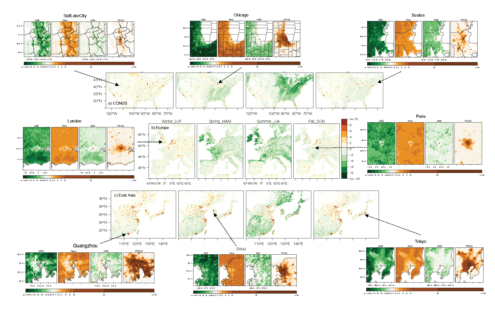
Urban Biogenic CO2 fluxes: GPP, Reco and NEE Estimates from SMUrF, 2010-2019
National Aeronautics and Space Administration —
This dataset contains estimates of biogenic CO2 flux components at 0.05 degree resolution from the Solar-Induced Fluorescence (SIF) for Modeling Urban biogenic Fluxes... -
Federal
SAFARI 2000 Modeled Fuel Load in Southern Africa, 1999-2000
National Aeronautics and Space Administration —
This data set contains global, spatially explicit (1 km2 grid cells) and temporally explicit (semi-monthly) modeled output of fuel loads over southern Africa. The... -
Federal
West Africa Coastal Vulnerability Mapping: Subset of OpenStreetMap (OSM) Roads
National Aeronautics and Space Administration —
The West Africa Coastal Vulnerability Mapping: Subset of OpenStreetMap (OSM) Roads data set includes roads within 200 kilometers of the coast and was extracted from... -
Federal
SAFARI 2000 ALI/ETM+ Tandem Image Pair for Skukuza, South Africa, May 2001
National Aeronautics and Space Administration —
A tandem pair of Advanced Land Imager (ALI) and Landsat Enhanced Thematic Mapper Plus (ETM+) scenes covering the same part of Kruger National Park (KNP), South Africa... -
Federal
SAFARI 2000 Derived Soil Properties, 0.5-Deg (ISRIC-WISE)
National Aeronautics and Space Administration —
The data set consists of a southern Africa subset of the ISRIC-WISE global data set of derived soil properties. The World Inventory of Soil Emission Potentials (WISE)...

Official websites use .gov
A
.gov website belongs to an official government
organization in the United States.
Secure .gov websites use HTTPS
A
lock (
) or https:// means you’ve safely connected to
the .gov website. Share sensitive information only on official,
secure websites.