
-
Federal
LBA-ECO ND-11 Pre-harvest Forest Tree and Liana Biomass, NW Mato Grosso, Brazil: 2003
National Aeronautics and Space Administration —
The purpose of this study was to determine if spatially-explicit commercial timber inventories (CTI) could be used in conjunction with satellite imagery to improve... -
Federal
Global Data Set of Derived Soil Properties, 0.5-Degree Grid (ISRIC-WISE)
National Aeronautics and Space Administration —
The World Inventory of Soil Emission Potentials (WISE) database currently contains data for over 4300 soil profiles collected mostly between 1950 and 1995. This... -
Federal
Global Gridded Surfaces of Selected Soil Characteristics (IGBP-DIS)
National Aeronautics and Space Administration —
The Global Gridded Surfaces of Selected Soil Characteristics (IGBP-DIS) data set contains 7 data surfaces: soil-carbon density, total nitrogen density, field... -
Federal
NACP Integrated Wildland and Cropland 30-m Fuel Characteristics Map, U.S.A., 2010
National Aeronautics and Space Administration —
The data set provides a 30-m comprehensive fuelbed characteristics map for both the wildland and cropland areas of the conterminous United States (CONUS) for 2010.... -
Federal
ABoVE: White Spruce Photosynthetic and Leaf Traits, Alaska and New York, 2017
National Aeronautics and Space Administration —
This dataset provides measurements of gas exchange (light response curves, Kok curves and ACi curves), leaf traits (carbon, nitrogen, and specific leaf area), leaf... -
Federal
NPP Multi-Biome: Gridded Estimates for Selected Regions Worldwide, 1954-1998, R3
National Aeronautics and Space Administration —
This data set provides two data files (.csv format) containing gridded (0.5-degree) estimates of net primary productivity (NPP), elevation, temperature,... -
Federal
SAFARI 2000 Derived Soil Properties, 0.5-Deg (ISRIC-WISE)
National Aeronautics and Space Administration —
The data set consists of a southern Africa subset of the ISRIC-WISE global data set of derived soil properties. The World Inventory of Soil Emission Potentials (WISE)... -
Federal
Land Surface Model (LSM 1.0) for Ecological, Hydrological, Atmospheric Studies
National Aeronautics and Space Administration —
The NCAR LSM 1.0 is a land surface model developed by Gordon Bonan to examine biogeophysical and biogeochemical land-atmosphere interactions, especially the effects... -
Federal
LBA-ECO ND-04 Secondary Forest Recovery, Structure, and LAI, Central Amazonia, Brazil
National Aeronautics and Space Administration —
This data set reports measurements of the canopy and structure of secondary forests regenerating from abandoned pastures. These secondary forests are located in the... -
Federal
ISLSCP II Climate Research Unit CRU05 Monthly Climate Data
National Aeronautics and Space Administration —
This data set contains a mean monthly climatology for several climate variables averaged over the period from 1961 to 1990, and constructed from a data set of station... -
Federal
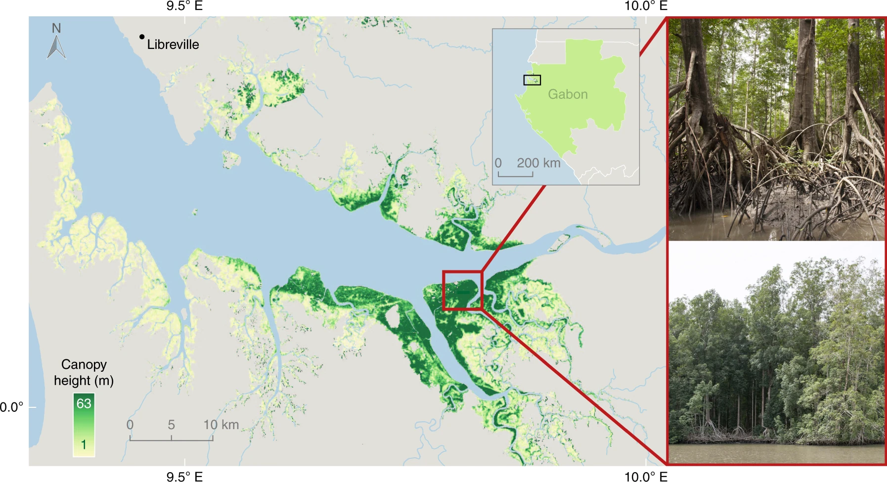
CMS: Global Mangrove Canopy Height Maps Derived from TanDEM-X, 2015
National Aeronautics and Space Administration —
This dataset characterizes canopy heights of mangrove-forested wetlands globally for 2015 at 12-m resolution. Estimates of maximum canopy height (height of the... -
Federal
PROVE Land Cover and Leaf Area of Jornada Experimental Range, New Mexico, 1997
National Aeronautics and Space Administration —
Field measurement of shrubland ecological properties is important for both site monitoring and validation of remote-sensing information. During the NASA Earth... -
Federal
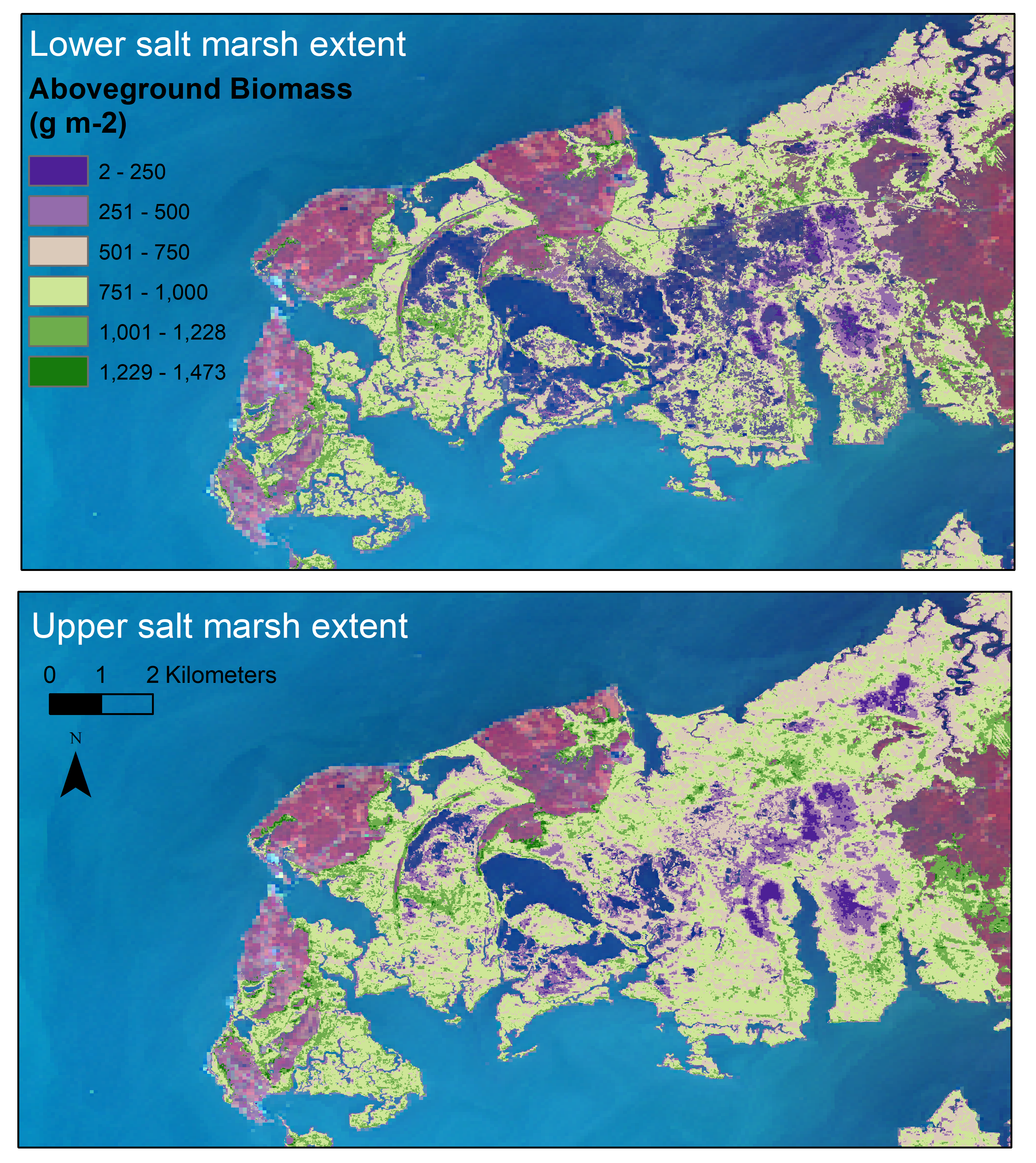
Aboveground Biomass Estimates for Salt Marsh for the Contiguous United States, 2020
National Aeronautics and Space Administration —
This dataset provides estimates of aboveground biomass (AGB) and salt marsh extent in the contiguous United States for 2020 and includes all coastal watersheds across... -
Federal
SORCE XPS Level 4 Solar Spectral Irradiance 0.1nm Res 5-Minute V012 (SOR4XPS5) at GES DISC
National Aeronautics and Space Administration —
The SORCE XPS Level 4 Solar Spectral Irradiance 0.1nm Res 5-Minute product (SOR4XPS5) contains modelled spectral extreme ultraviolet (XUV) irradiances based on... -
Federal
Digital Elevation Models for the Global Change Research Wetland, Maryland, USA, 2016
National Aeronautics and Space Administration —
This dataset contains four alternative digital elevation models (DEMs) at 1 m resolution and model performance statistical metrics for the Global Change Research... -
Federal
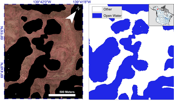
ABoVE: AirSWOT Water Masks from Color-Infrared Imagery over Alaska and Canada, 2017
National Aeronautics and Space Administration —
This dataset provides 1) a conservative open water mask for future water surface elevation (WSE) extraction from the co-registered AirSWOT Ka-band interferometry... -
Federal
LBA-ECO LC-24 Cadastral Property Map of Uruara, Para, Brazil: ca.1975
National Aeronautics and Space Administration —
This data set contains a shapefile of a digitized map of the land parcel information of the original properties of the Uruara colonization site, Para, Brazil,... -
Federal
SORCE XPS Level 4 Solar Spectral Irradiance 0.1nm Res 24-Hour Means V012 (SOR4XPSD_HIGH) at GES DISC
National Aeronautics and Space Administration —
The SORCE XPS Level 4 Solar Spectral Irradiance 0.1nm Res 24-Hour Means product (SOR4XPSD_HIGH) contains modelled spectral extreme ultraviolet (XUV) irradiances based...

Official websites use .gov
A
.gov website belongs to an official government
organization in the United States.
Secure .gov websites use HTTPS
A
lock (
) or https:// means you’ve safely connected to
the .gov website. Share sensitive information only on official,
secure websites.