
-
Federal
NACP Integrated Wildland and Cropland 30-m Fuel Characteristics Map, U.S.A., 2010
National Aeronautics and Space Administration —
The data set provides a 30-m comprehensive fuelbed characteristics map for both the wildland and cropland areas of the conterminous United States (CONUS) for 2010.... -
Federal
Global Gridded Surfaces of Selected Soil Characteristics (IGBP-DIS)
National Aeronautics and Space Administration —
The Global Gridded Surfaces of Selected Soil Characteristics (IGBP-DIS) data set contains 7 data surfaces: soil-carbon density, total nitrogen density, field... -
Federal
Fermi GBM Burst Catalog
National Aeronautics and Space Administration —
When referencing results from this online catalog, please cite von Kienlin, A. et al. 2020, Gruber, D. et al. 2014, von Kienlin, A. et al. 2014, and Bhat, P. et al.... -
Federal
NPP Multi-Biome: Gridded Estimates for Selected Regions Worldwide, 1954-1998, R3
National Aeronautics and Space Administration —
This data set provides two data files (.csv format) containing gridded (0.5-degree) estimates of net primary productivity (NPP), elevation, temperature,... -
Federal
SAFARI 2000 Derived Soil Properties, 0.5-Deg (ISRIC-WISE)
National Aeronautics and Space Administration —
The data set consists of a southern Africa subset of the ISRIC-WISE global data set of derived soil properties. The World Inventory of Soil Emission Potentials (WISE)... -
Federal
Land Surface Model (LSM 1.0) for Ecological, Hydrological, Atmospheric Studies
National Aeronautics and Space Administration —
The NCAR LSM 1.0 is a land surface model developed by Gordon Bonan to examine biogeophysical and biogeochemical land-atmosphere interactions, especially the effects... -
Federal
LBA-ECO ND-04 Secondary Forest Recovery, Structure, and LAI, Central Amazonia, Brazil
National Aeronautics and Space Administration —
This data set reports measurements of the canopy and structure of secondary forests regenerating from abandoned pastures. These secondary forests are located in the... -
Federal
ISLSCP II Climate Research Unit CRU05 Monthly Climate Data
National Aeronautics and Space Administration —
This data set contains a mean monthly climatology for several climate variables averaged over the period from 1961 to 1990, and constructed from a data set of station... -
Federal
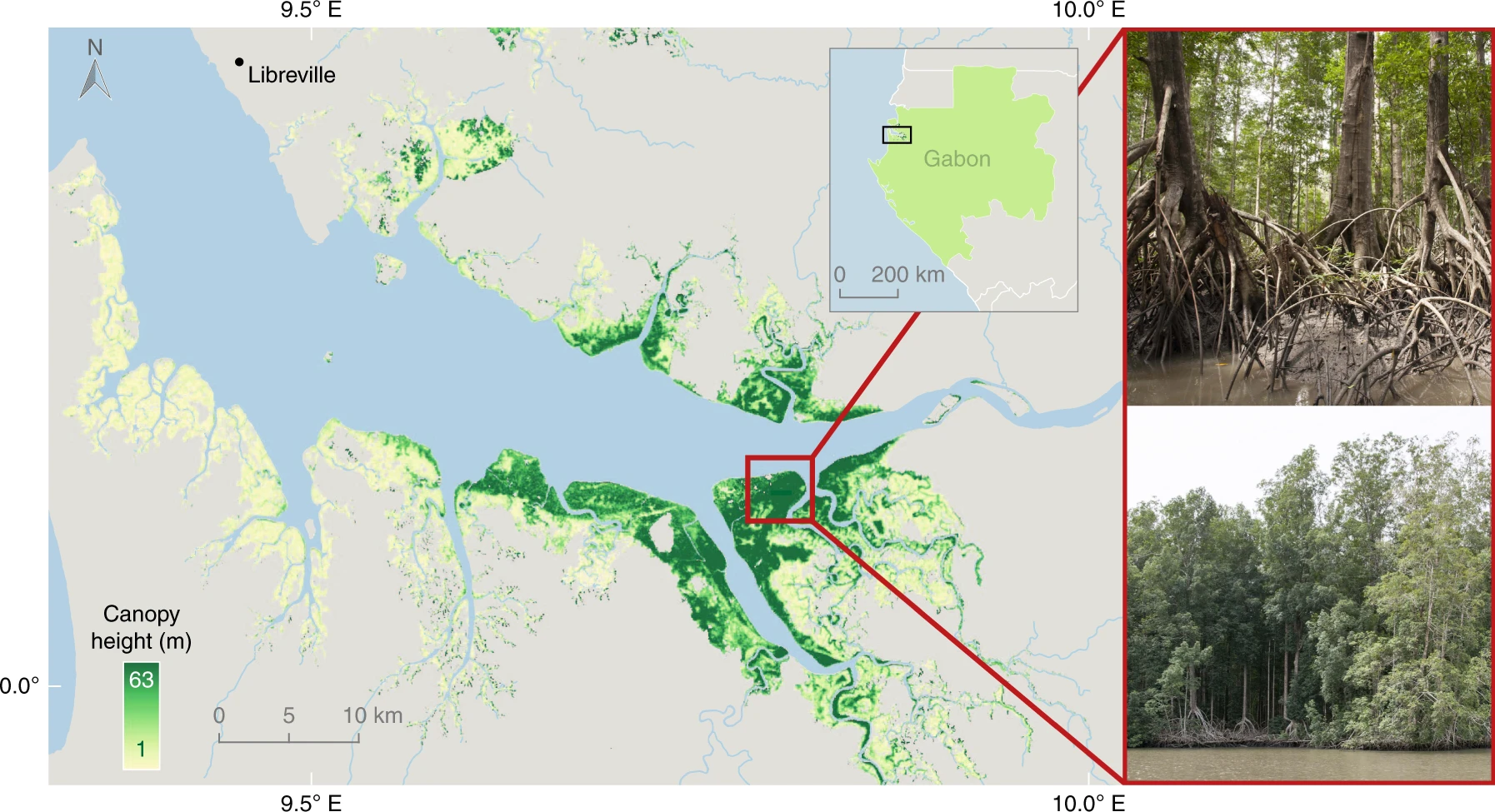
CMS: Global Mangrove Canopy Height Maps Derived from TanDEM-X, 2015
National Aeronautics and Space Administration —
This dataset characterizes canopy heights of mangrove-forested wetlands globally for 2015 at 12-m resolution. Estimates of maximum canopy height (height of the... -
Federal
PROVE Land Cover and Leaf Area of Jornada Experimental Range, New Mexico, 1997
National Aeronautics and Space Administration —
Field measurement of shrubland ecological properties is important for both site monitoring and validation of remote-sensing information. During the NASA Earth... -
Federal
SORCE XPS Level 4 Solar Spectral Irradiance 0.1nm Res 5-Minute V012 (SOR4XPS5) at GES DISC
National Aeronautics and Space Administration —
The SORCE XPS Level 4 Solar Spectral Irradiance 0.1nm Res 5-Minute product (SOR4XPS5) contains modelled spectral extreme ultraviolet (XUV) irradiances based on... -
Federal
Digital Elevation Models for the Global Change Research Wetland, Maryland, USA, 2016
National Aeronautics and Space Administration —
This dataset contains four alternative digital elevation models (DEMs) at 1 m resolution and model performance statistical metrics for the Global Change Research... -
Federal
SORCE XPS Level 4 Solar Spectral Irradiance 0.1nm Res 24-Hour Means V012 (SOR4XPSD_HIGH) at GES DISC
National Aeronautics and Space Administration —
The SORCE XPS Level 4 Solar Spectral Irradiance 0.1nm Res 24-Hour Means product (SOR4XPSD_HIGH) contains modelled spectral extreme ultraviolet (XUV) irradiances based... -
Federal
LBA-ECO ND-11 Pre-harvest Forest Tree and Liana Biomass, NW Mato Grosso, Brazil: 2003
National Aeronautics and Space Administration —
The purpose of this study was to determine if spatially-explicit commercial timber inventories (CTI) could be used in conjunction with satellite imagery to improve... -
Federal
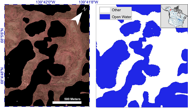
ABoVE: AirSWOT Water Masks from Color-Infrared Imagery over Alaska and Canada, 2017
National Aeronautics and Space Administration —
This dataset provides 1) a conservative open water mask for future water surface elevation (WSE) extraction from the co-registered AirSWOT Ka-band interferometry... -
Federal
LBA-ECO LC-24 Cadastral Property Map of Uruara, Para, Brazil: ca.1975
National Aeronautics and Space Administration —
This data set contains a shapefile of a digitized map of the land parcel information of the original properties of the Uruara colonization site, Para, Brazil,... -
Federal
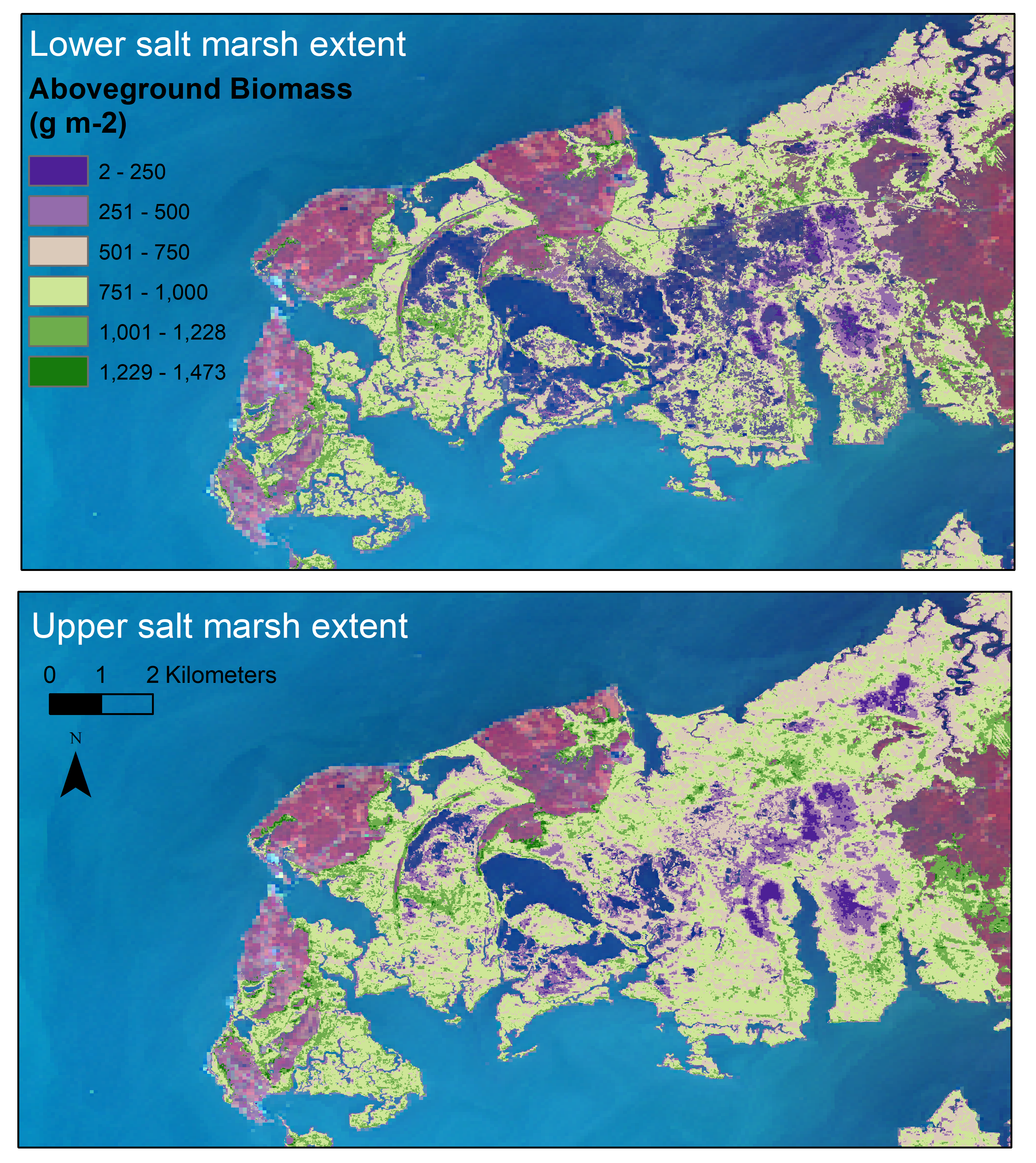
Aboveground Biomass Estimates for Salt Marsh for the Contiguous United States, 2020
National Aeronautics and Space Administration —
This dataset provides estimates of aboveground biomass (AGB) and salt marsh extent in the contiguous United States for 2020 and includes all coastal watersheds across... -
Federal
ABoVE: White Spruce Photosynthetic and Leaf Traits, Alaska and New York, 2017
National Aeronautics and Space Administration —
This dataset provides measurements of gas exchange (light response curves, Kok curves and ACi curves), leaf traits (carbon, nitrogen, and specific leaf area), leaf... -
Federal
DE 2 Vector Electric Field Instrument, VEFI, Magnetometer, MAG-B, Merged Magnetic and Electric Field Parameters, 62 ms Data
National Aeronautics and Space Administration —
This Dynamics Explorer 2, DE 2, data set is a combination of the Vector Electric Field Instrument, VEFI, and Magnetometer-B, MAGB, high resolution data sets in...

Official websites use .gov
A
.gov website belongs to an official government
organization in the United States.
Secure .gov websites use HTTPS
A
lock (
) or https:// means you’ve safely connected to
the .gov website. Share sensitive information only on official,
secure websites.