
-
Federal
ASTER Global Digital Elevation Model V003
National Aeronautics and Space Administration —
The Terra Advanced Spaceborne Thermal Emission and Reflection Radiometer (ASTER) Global Digital Elevation Model (GDEM) Version 3 (ASTGTM) provides a global digital... -
Federal
Bright Star Catalog
National Aeronautics and Space Administration —
The BSC5P database table contains data derived from the Bright Star Catalog, 5th Edition, preliminary, which is widely used as a source of basic astronomical and... -
Federal
Combined GPS Broadcast Ephemeris Data (30-second sampling, hourly files) from NASA CDDIS
National Aeronautics and Space Administration —
This dataset consists of ground-based Global Navigation Satellite System (GNSS) Combined Broadcast Ephemeris Data (hourly files of all distinct navigation messages... -
Federal
Catalog of Gamma-Ray Bursts
National Aeronautics and Space Administration —
This GRBs Catalog (GRBCAT) records high level information of the GRBs detected since their discovery in 1967. The catalog has been created using publications that... -
Federal
Global Vegetation Greenness (NDVI) from AVHRR GIMMS-3G+, 1981-2022
National Aeronautics and Space Administration —
This dataset holds the Global Inventory Modeling and Mapping Studies-3rd Generation V1.2 (GIMMS-3G+) data for the Normalized Difference Vegetation Index (NDVI). NDVI... -
Federal
Greenland Ice Sheet Melt Characteristics Derived from Passive Microwave Data, Version 1
National Aeronautics and Space Administration —
The Greenland ice sheet melt extent data, acquired as part of the NASA Program for Arctic Regional Climate Assessment (PARCA), is a daily (or every other day, prior... -
Federal
Tycho-2 Catalog of the 2.5 Million Brightest Stars
National Aeronautics and Space Administration —
The Hipparcos and Tycho catalogs are the primary products of the European Space Agency's astrometric mission, Hipparcos. The satellite, which operated for four years,... -
Federal
Global Hydrologic Soil Groups (HYSOGs250m) for Curve Number-Based Runoff Modeling
National Aeronautics and Space Administration —
This dataset - HYSOGs250m - represents a globally consistent, gridded dataset of hydrologic soil groups (HSGs) with a geographical resolution of 1/480 decimal... -
Federal
Aquarius Official Release Level 3 Ancillary Reynolds Sea Surface Temperature Standard Mapped Image Daily Data V5.0
National Aeronautics and Space Administration —
Aquarius Level 3 ancillary sea surface temperature (SST) standard mapped image data are the ancillary SST data used in the Aquarius calibration for salinity... -
Federal
Airborne Hyperspectral Reflectance L1 Tallgrass Prairie Preserve Oklahoma Multi-Day 1 m
National Aeronautics and Space Administration —
The Airborne Hyperspectral Reflectance data are from The Nature Conservancy’s Tallgrass Prairie Preserve in northeastern Oklahoma. The data have a spatial resolution... -
Federal
OCO-2 Level 2 CO2 prior based on CO2 monthly flask record, global meteorology, and age of air Retrospective Processing V11.2r (OCO2_L2_CO2Prior) at GES DISC
National Aeronautics and Space Administration —
Version 11.2r is the current version of the data set. Older versions will no longer be available and are superseded by Version 11.2r.The Orbiting Carbon Observatory... -
Federal
General Catalog of Variable Stars (June 2022 Version)
National Aeronautics and Space Administration —
Work aimed at compiling detailed catalogs of variable stars in the Galaxy, which has been carried out continuously by Moscow variable-star researchers since 1946 on... -
Federal
Arctic Vegetation Plots for IBP Tundra Biome, Barrow, Alaska, 1972-2010
National Aeronautics and Space Administration —
This data set provides vegetation cover and environmental plot data collected as part of the International Biological Program (IBP), U. S. Tundra Biome Program, in... -
Federal
MERRA-2 tavg3_3d_qdt_Np: 3d,3-Hourly,Time-Averaged,Pressure-Level,Assimilation,Moist Tendencies 0.625 x 0.5 degree V5.12.4 (M2T3NPQDT) at GES DISC
National Aeronautics and Space Administration —
M2T3NPQDT (or tavg3_3d_qdt_Np) is a 3-dimensional 3-hourly time averaged data collection in Modern-Era Retrospective analysis for Research and Applications version 2... -
Federal
SARP 2019 Data
National Aeronautics and Space Administration —
SARP_2019_Data is the data collected onboard the NASA DC-8 aircraft during the 2019 deployment of the Student Airborne Research Program (SARP) mission. Data... -
Federal
BOREAS TF-11 CO2 and CH4 Flux Data from the SSA-Fen
National Aeronautics and Space Administration —
The BOREAS TF-11 team collected several data sets in their efforts to fully describe the flux and site characteristics at the SSA-Fen site. This data set contains... -
Federal
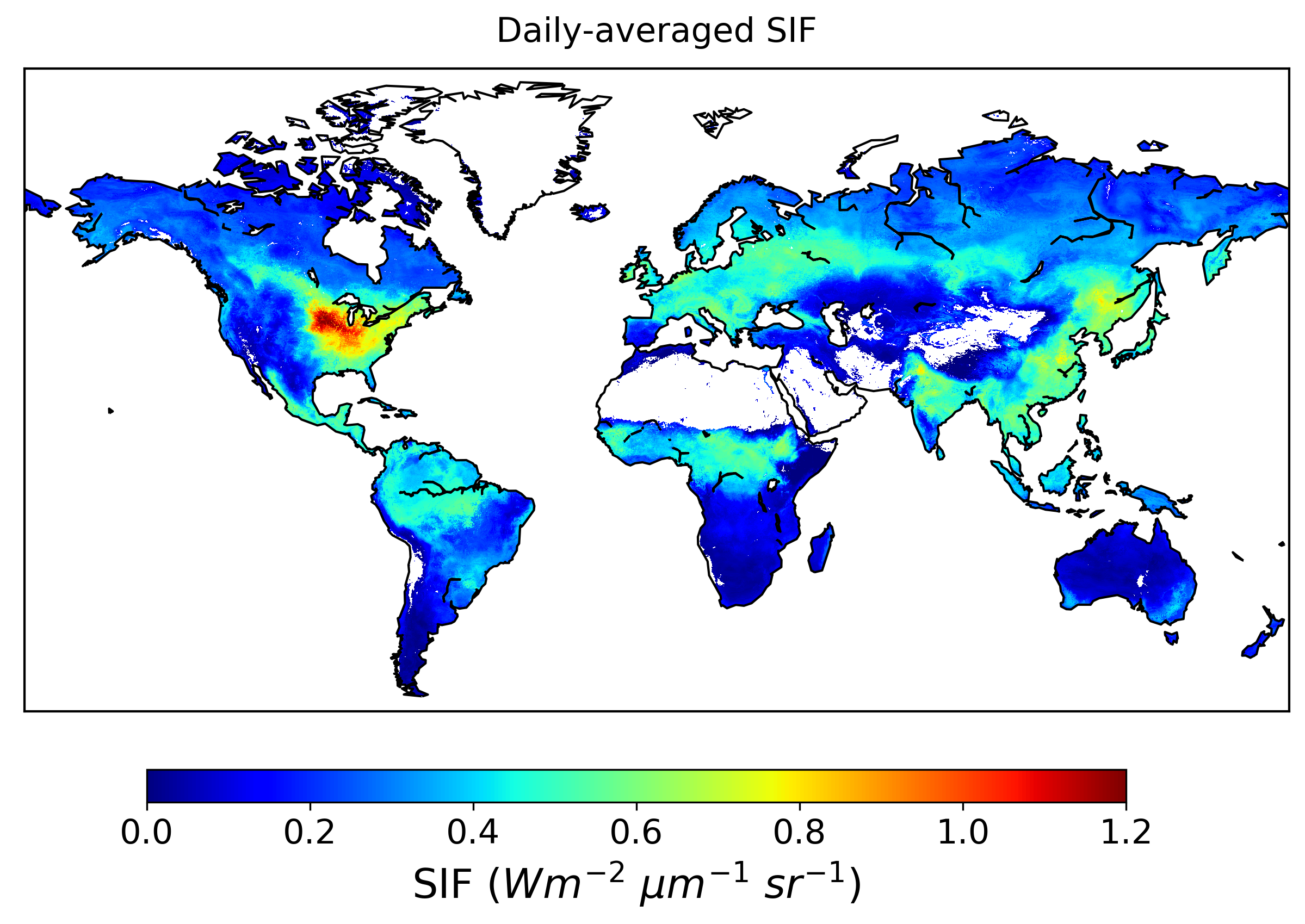
Global High-Resolution Estimates of SIF from Fused SCIAMACHY and GOME-2, V2
National Aeronautics and Space Administration —
This dataset provides global solar-induced chlorophyll fluorescence (SIF) estimates at a 0.05-degree resolution (approximately 5 km at the equator) for each month... -
Federal
GPM Ground Validation Conical Scanning Millimeter-wave Imaging Radiometer (CoSMIR) OLYMPEX
National Aeronautics and Space Administration —
The GPM Ground Validation Conical Scanning Millimeter-wave Imaging Radiometer (CoSMIR) OLYMPEX dataset consists of brightness temperatures from 9 channels as measured... -
Federal
ASTER Level 1T Precision Terrain Corrected Registered At-Sensor Radiance V004
National Aeronautics and Space Administration —
The Terra Advanced Spaceborne Thermal Emission and Reflection Radiometer (ASTER) Level 1 Precision Terrain Corrected Registered At-Sensor Radiance (AST_L1T) data...

Official websites use .gov
A
.gov website belongs to an official government
organization in the United States.
Secure .gov websites use HTTPS
A
lock (
) or https:// means you’ve safely connected to
the .gov website. Share sensitive information only on official,
secure websites.