
-
Federal
Global Landslide Catalog Export
National Aeronautics and Space Administration —
The Global Landslide Catalog (GLC) was developed with the goal of identifying rainfall-triggered landslide events around the world, regardless of size, impacts or... -
Federal
Outgassing Db
National Aeronautics and Space Administration —
This tenth compilation of outgassing data of materials intended for spacecraft use supersedes Reference Publication 1124, Revision 3, September 1993. The data were... -
Federal
ISS_COORDS_2021-12-14
National Aeronautics and Space Administration —
This data represents the best estimated real-time trajectory and local sightings opportunities for the International Space Station (ISS) as generated by the... -
Federal
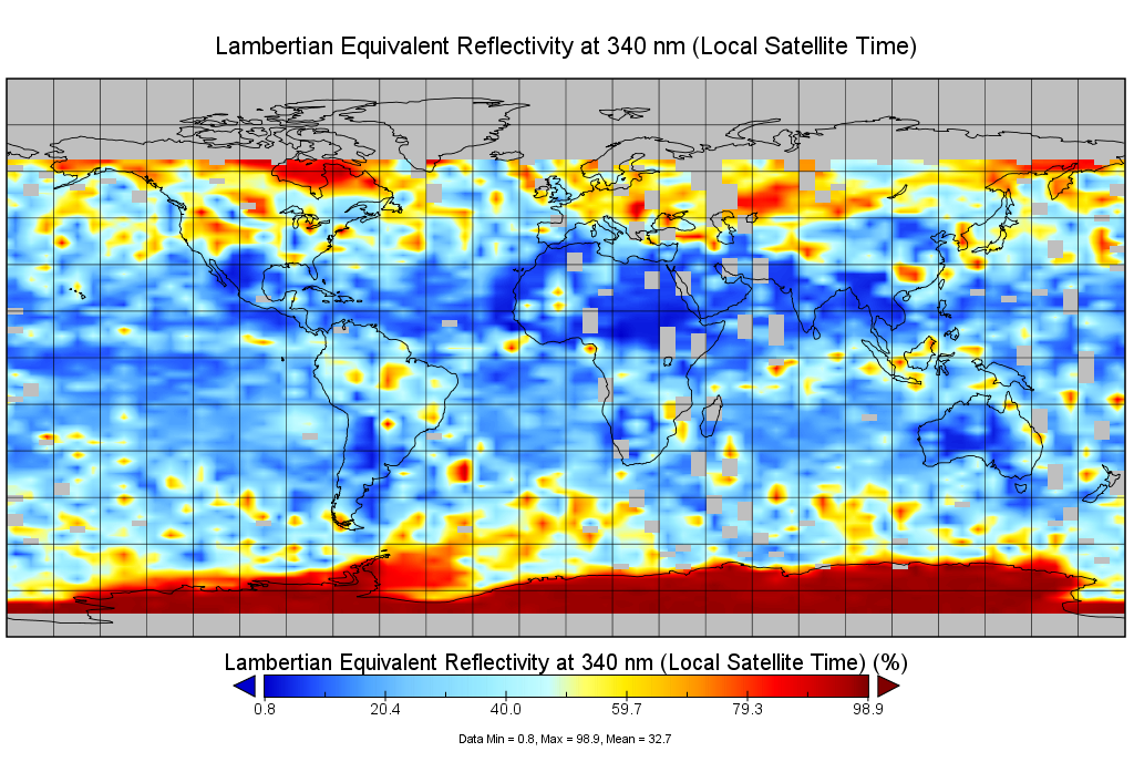
Multi-Satellite Lambertian Equivalent Reflectivity (Noon Normalized) 10-Day L3 Global 2.0x5.0deg Lat/Lon Grid V1 (MSLERNNL3d10) at GES DISC
National Aeronautics and Space Administration —
The Multi-Satellite Lambertian Equivalent Reflectivity (Noon Normalized) 10-Day L3 Global 2.0x5.0deg Lat/Lon Grid data product is derived from multi-satellite Solar... -
Federal
Advanced Exploration Systems Program
National Aeronautics and Space Administration —
AES consists of more than 35 projects that target high-priority capabilities needed for human exploration such as crew mobility, deep-space habitation, vehicle... -
Federal
Next-Generation Real-Time Geodetic Station Sensor Web for Natural Hazards Research and Applications Project
National Aeronautics and Space Administration —
N/A -
Federal
CAMP2Ex Learjet In-Situ Aerosol Data
National Aeronautics and Space Administration —
CAMP2Ex_Aerosol_AircraftInSitu_Learjet_Data are in-situ aerosol measurements conducted onboard the SPEC Learjet aircraft during the Clouds, Aerosol and Monsoon... -
Federal
Risk reduction for the PATH mission Project
National Aeronautics and Space Administration —
N/A -
Federal
ISS_COORDS_2021-07-22
National Aeronautics and Space Administration —
This data represents the best estimated real-time trajectory and local sightings opportunities for the International Space Station (ISS) as generated by the... -
Federal
ISS_COORDS_2021-07-09
National Aeronautics and Space Administration —
This data represents the best estimated real-time trajectory and local sightings opportunities for the International Space Station (ISS) as generated by the... -
Federal
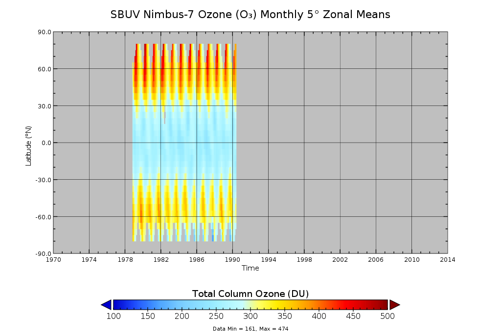
SBUV/Nimbus-7 Ozone (O3) Profile and Total Column Ozone 1 Month Zonal Mean L3 Global 5.0 degree Latitude Zones V1 (SBUVN07L3zm) at GES DISC
National Aeronautics and Space Administration —
The Solar Backscattered Ultraviolet (SBUV) from Nimbus-7 Level-3 monthly zonal mean (MZM) product (SBUVN07L3zm) is derived from the Level-2 retrieved ozone profiles.... -
Federal
Emission Line Astronomy - Coronagraphic Tunable Narrow Band Imaging and Integral Field Spectroscopy. Project
National Aeronautics and Space Administration —
We propose to continue our program of emission line astronomy featuring three areas of emphasis: 1) The distribution and nature of high redshift emission line... -
Federal
ARISE 2014 C-130 Remotely Sensed Aerosol and Trace Gas Data
National Aeronautics and Space Administration —
ARISE_Cloud_AircraftInSitu_C130_Data_1 is the Arctic Radiation - IceBridge Sea & Ice Experiment (ARISE) 2014 in-situ cloud data product. This product is a result... -
Federal
ISS_COORDS_2022-01-29
National Aeronautics and Space Administration —
This data represents the best estimated real-time trajectory and local sightings opportunities for the International Space Station (ISS) as generated by the... -
Federal
ISS_COORDS_2021-09-14
National Aeronautics and Space Administration —
This data represents the best estimated real-time trajectory and local sightings opportunities for the International Space Station (ISS) as generated by the... -
Federal
ISS_COORDS_2021-02-27
National Aeronautics and Space Administration —
This data represents the best estimated real-time trajectory and local sightings opportunities for the International Space Station (ISS) as generated by the... -
Federal
Auroral Spatial Structures Probe Project
National Aeronautics and Space Administration —
Methodology Fly a high altitude sounding rocket with multiple sub-payloads to measure electric and magnetic fields during an auroral event. Use ground... -
Federal
ISS_COORDS_2021-06-15
National Aeronautics and Space Administration —
This data represents the best estimated real-time trajectory and local sightings opportunities for the International Space Station (ISS) as generated by the... -
Federal
ISS_COORDS_2022-02-20
National Aeronautics and Space Administration —
This data represents the best estimated real-time trajectory and local sightings opportunities for the International Space Station (ISS) as generated by the... -
Federal
ISS_COORDS_2021-04-06
National Aeronautics and Space Administration —
This data represents the best estimated real-time trajectory and local sightings opportunities for the International Space Station (ISS) as generated by the...

Official websites use .gov
A
.gov website belongs to an official government
organization in the United States.
Secure .gov websites use HTTPS
A
lock (
) or https:// means you’ve safely connected to
the .gov website. Share sensitive information only on official,
secure websites.