
-
Federal
Real System Failures
National Aeronautics and Space Administration —
This resource area contains descriptions of actual electronic systems failure scenarios with an emphasis on the diversity of failure modes and effects that can befall... -
Federal
TRMM Precipitation Radar Rain Characteristics L2 1.5 hours V7 (TRMM_2A23) at GES DISC
National Aeronautics and Space Administration —
The new version of these data is in GPM-like format (consistent with the GPM Dual-frequency Radar data format), and can be found under the name GPM_2APR. The TRMM... -
Federal
TRMM Precipitation Radar Rainfall Rate and Profile L2 1.5 hours V7 (TRMM_2A25) at GES DISC
National Aeronautics and Space Administration —
The new version of these data is in GPM-like format (consistent with the GPM Dual-frequency Radar data format), and can be found under the name GPM_2APR. The TRMM... -
Federal
GEDI L4B Gridded Aboveground Biomass Density, Version 2
National Aeronautics and Space Administration —
This Global Ecosystem Dynamics Investigation (GEDI) L4B product provides 1 km x 1 km (1 km, hereafter) estimates of mean aboveground biomass density (AGBD) based on... -
Federal
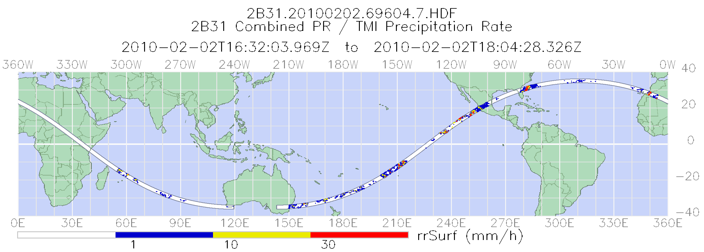
TRMM Combined Precipitation Radar and Microwave Imager Rainfall Profile L2 1.5 hours V7 (TRMM_2B31) at GES DISC
National Aeronautics and Space Administration —
The TRMM combined algorithm (2B31) combines data from the TMI and PR to produce the best rain estimate for TRMM. This combined rainfall product is derived from... -
Federal
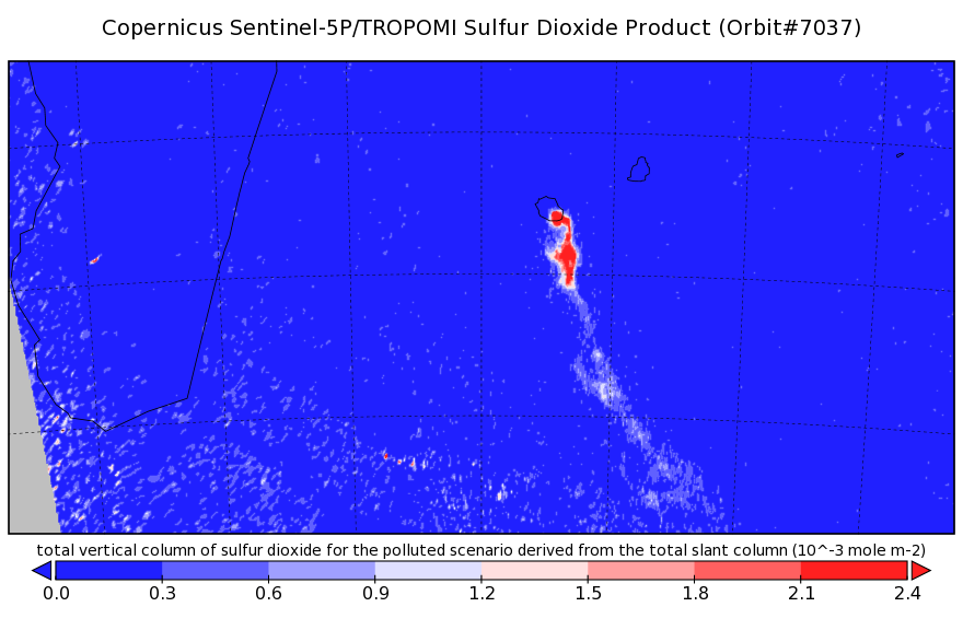
Sentinel-5P TROPOMI Sulphur Dioxide SO2 1-Orbit L2 7km x 3.5km V1 (S5P_L2__SO2___) at GES DISC
National Aeronautics and Space Administration —
Starting from August 6th in 2019, Sentinel-5P TROPOMI along-track high spatial resolution (~5.5km at nadir) has been implemented. Starting from July 13th in 2020,... -
Federal
SIRS/Nimbus-3 Level 1 Radiance Data V001 (SIRSN3L1) at GES DISC
National Aeronautics and Space Administration —
SIRSN3L1 is the Nimbus-3 Satellite Infrared Spectrometer (SIRS) Level 1 Radiance Data product. SIRS measured infrared radiation (11 to 36 micrometers) emitted from... -
Federal
Sentinel-1 Interferograms - Unwrapped Phase (BETA)
National Aeronautics and Space Administration —
Sentinel-1 SLC interferometric products generated by JPL using ISCE v2.0.0, delivered by ASF -
Federal
GPM GROUND VALIDATION DUAL-FREQUENCY DUAL-POLARIZED DOPPLER RADAR (D3R) GCPEX V1
National Aeronautics and Space Administration —
The GPM Ground Validation Dual-frequency Dual-polarized Doppler Radar (D3R) GCPEx and IFloodS data sets contain radar reflectivity and doppler velocity measurements.... -
Federal
GPM MHS on METOP-B (GPROF) Climate-based Radiometer Precipitation Profiling L3 1 day 0.25 degree x 0.25 degree V07 (GPM_3GPROFMETOPBMHS_DAY_CLIM) at GES DISC
National Aeronautics and Space Administration —
Version 07 is the current version of the data set. Older versions are no longer available and have been superseded by Version 07. The "CLIM" products differ from... -
Federal
GEDI L4A Footprint Level Aboveground Biomass Density, Version 2.1
National Aeronautics and Space Administration —
This dataset contains Global Ecosystem Dynamics Investigation (GEDI) Level 4A (L4A) Version 2 predictions of the aboveground biomass density (AGBD; in Mg/ha) and... -
Federal
In-situ Air Temperature and Relative Humidity in Greenbelt, MD, 2013-2015
National Aeronautics and Space Administration —
This data set describes the temperature and relative humidity at 12 locations around Goddard Space Flight Center in Greenbelt MD at 15 minute intervals between... -
Federal
UARS Wind Imaging Interferometer (WINDII) Level 3AT V011 (UARWI3AT) at GES DISC
National Aeronautics and Space Administration —
The Wind Imaging Interferometer (WINDII) Level 3AT data product consists of daily, 65.536 second interval time-ordered vertical profiles of meridional and zonal wind... -
Federal
THIR/Nimbus-7 Level 1 Calibrated Located Radiation Data at 6.7 and 11.5 microns V001 (THIRN7L1CLDT) at GES DISC
National Aeronautics and Space Administration —
THIRN7L1CLDT is the Nimbus-7 Temperature-Humidity Infrared Radiometer (THIR) Level 1 Calibrated Located Radiation Data (CLDT) at 6.7 and 11.5 microns product and... -
Federal
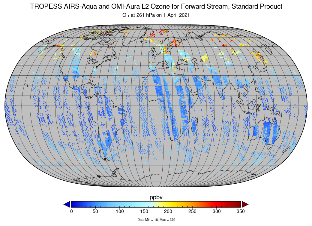
TROPESS AIRS-Aqua and OMI-Aura L2 Ozone for Forward Stream, Standard Product V1 (TRPSDL2O3AIRSOMIFS) at GES DISC
National Aeronautics and Space Administration —
The TROPESS AIRS-Aqua and OMI-Aura L2 Ozone for Forward Stream, Standard Product contains the vertical distribution of the retrieved atmospheric state of ozone (O3),... -
Federal
CERES Monthly Daytime Mean Regionally Averaged NOAA-20 TOA Fluxes and Associated Cloud Properties Stratified by Optical Depth and Effective Pressure Edition1B
National Aeronautics and Space Administration —
CER_FluxByCldTyp-Month_NOAA20-VIIRS_Edition1B is the Clouds and the Earth's Radiant Energy System (CERES) Monthly Daytime Mean Regionally Averaged NOAA-20 Top-of-... -
Federal
Site Averaged AMS Data: 1989 (Betts)
National Aeronautics and Space Administration —
The Site Averaged AMS Data: 1989 (Betts) Data Set contains the site averaged product of the Portable Automatic Meteorological Station (AMS) data acquired during the... -
Federal
Soil Bulk Density Data (FIFE)
National Aeronautics and Space Administration —
Soil bulk density is defined as the ratio of the mass of dry solids to the bulk volume of the soil occupied by those dry solids. Bulk density of the soil is an... -
Federal
Satellite Landsat TM Extr. Data (FIFE)
National Aeronautics and Space Administration —
The Thematic Mapper sensor system was used to collect the original data between February 1987 and October 1989 from which this data set was produced. Landsat TM...

Official websites use .gov
A
.gov website belongs to an official government
organization in the United States.
Secure .gov websites use HTTPS
A
lock (
) or https:// means you’ve safely connected to
the .gov website. Share sensitive information only on official,
secure websites.