
-
Federal
Spatial Data from the 2011 India Census
National Aeronautics and Space Administration —
The Spatial Data from the 2011 India Census contains gridded estimates of India population at a resolution of 1 kilometer along with two spatial renderings of urban... -
Federal
India Village-Level Geospatial Socio-Economic Data Set: 1991, 2001
National Aeronautics and Space Administration —
The India Village-Level Geospatial Socio-Economic Data Set: 1991, 2001 is a compilation of the finest level of administrative boundaries in India (village/town-level)... -
Federal
SDG Indicator 7.1.1: Access to Electricity, 2023 Release
National Aeronautics and Space Administration —
The SDG Indicator 7.1.1: Access to Electricity, 2023 Release data set, part of the Sustainable Development Goal Indicators (SDGI) collection, measures the proportion... -
Federal
Global Fertilizer and Manure, Version 1: Nitrogen in Manure Production
National Aeronautics and Space Administration —
The Nitrogen in Manure Production data set of the Global Fertilizer and Manure, Version 1 Data Collection represents the amount of nitrogen manure produced and... -
Federal
Global Annual PM2.5 Grids from MODIS, MISR and SeaWiFS Aerosol Optical Depth (AOD), 1998-2019, V4.GL.03 NGDA
National Aeronautics and Space Administration —
The Global Annual PM2.5 Grids from MODIS, MISR and SeaWiFS Aerosol Optical Depth (AOD), 1998-2019, V4.GL.03 consists of annual concentrations (micrograms per cubic... -
Federal
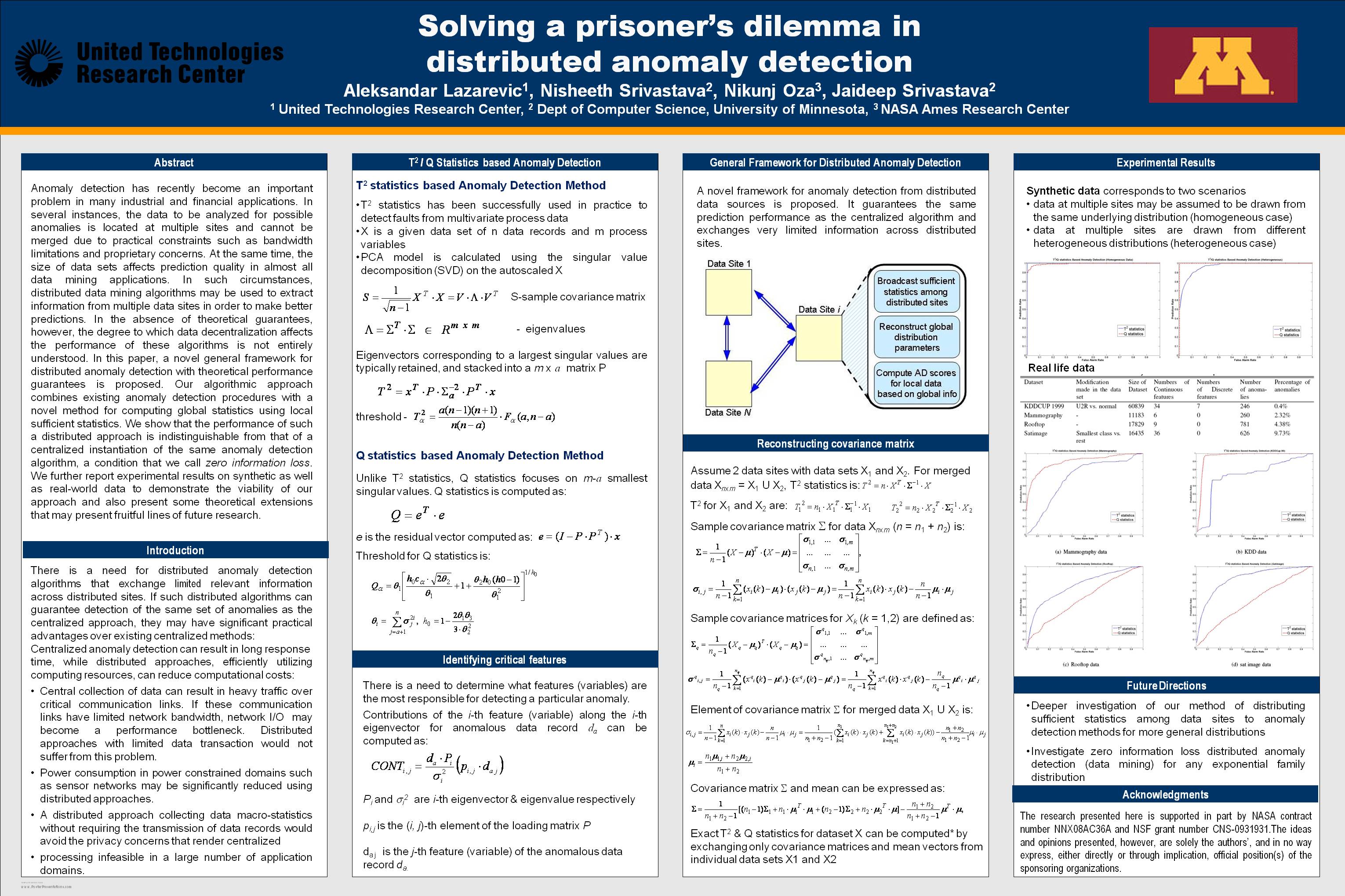
Solving a prisoner's dilemma in distributed anomaly detection
National Aeronautics and Space Administration —
Anomaly detection has recently become an important problem in many industrial and financial applications. In several instances, the data to be analyzed for possible... -
Federal
MODIS/Terra+Aqua Land Cover Type Yearly L3 Global 0.05Deg CMG V006
National Aeronautics and Space Administration —
The MCD12C1 Version 6 data product was decommissioned on July 31, 2023. Users are encouraged to use the MCD12C1 Version 6.1 data product.The Terra and Aqua combined... -
Federal
Population Exposure Estimates in Proximity to Nuclear Power Plants, Locations
National Aeronautics and Space Administration —
The Population Exposure Estimates in Proximity to Nuclear Power Plants, Locations data set combines information from a global data set developed by Declan Butler of... -
Federal
West Africa Coastal Vulnerability Mapping: Demographic and Health Survey Data Sets
National Aeronautics and Space Administration —
The West Africa Coastal Vulnerability Mapping: Demographic and Health Survey Data Sets present grids of maternal education levels and household wealth based on... -
Federal
MODIS/Terra+Aqua BRDF/Albedo Albedo Daily L3 Global - 500m V061
National Aeronautics and Space Administration —
The Moderate Resolution Imaging Spectroradiometer (MODIS) MCD43A3 Version 6.1 Albedo Model dataset is produced daily using 16 days of Terra and Aqua MODIS data at 500... -
Federal
ABoVE: Passive Microwave-derived Annual Snowpack Main Melt Onset Date Maps, 1988-2023
National Aeronautics and Space Administration —
This dataset provides the annual date of snowpack seasonal beginning melt (i.e., main melt onset date, MMOD) across northwest Canada, Alaska, US, and parts of far... -
Federal
Africa Climate Mobility Initiative (ACMI): Internal Migration Projections
National Aeronautics and Space Administration —
The Africa Climate Mobility Initiative (ACMI) Internal Migration Projections project internal migration flows at 5-year intervals from 2020 to 2050 for a combination... -
Federal
Global Food Security-support Analysis Data (GFSAD) Cropland Extent 2015 Australia, New Zealand, China, Mongolia 30 m V001
National Aeronautics and Space Administration —
The NASA Making Earth System Data Records for Use in Research Environments (MEaSUREs) Global Food Security-support Analysis Data (GFSAD) data product provides... -
Federal
MLS/Aura Near-Real-Time L2 Sulfur Dioxide (SO2) Mixing Ratio V005 (ML2SO2_NRT) at GES DISC
National Aeronautics and Space Administration —
ML2SO2_NRT is the EOS Aura Microwave Limb Sounder (MLS) Near-Real-Time (NRT) product for sulfur dioxide (SO2). This product contains SO2 profiles derived from the 190... -
Federal
OCO-3 Level 2 CO2 prior based on CO2 monthly flask record, global meteorology, and age of air, Forward Processing V11 (OCO3_L2_CO2Prior) at GES DISC
National Aeronautics and Space Administration —
Version 11 is the current version of the data set. Older versions will no longer be available and are superseded by Version 11. The Orbiting Carbon Observatory -3... -
Federal
CYGNSS L3 Ocean Microplastic Concentration V1.0
National Aeronautics and Space Administration —
This dataset contains the version 1.0 CYGNSS level 3 ocean microplastic concentration data record, which provides 18 netCDF files, each containing one month of daily... -
Federal
Dar es Salaam Land Use and Informal Settlement Data Set
National Aeronautics and Space Administration —
The Dar es Salaam Land Use and Informal Settlement Data Set represents urban land use and consolidation of informal settlements for the years 1982, 1992, 1998, and... -
Federal
African Climate Mobility Initiative (ACMI): Bilateral Migration Projections
National Aeronautics and Space Administration —
The African Climate Mobility Initiative (ACMI): Bilateral Migration Projections consists of projections for bilateral migration flows at 5-year intervals from 2015 to... -
Federal
ASTER L2 Surface Reflectance SWIR and ASTER L2 Surface Reflectance VNIR V003
National Aeronautics and Space Administration —
The Terra Advanced Spaceborne Thermal Emission and Reflection Radiometer (ASTER) Surface Reflectance VNIR and SWIR (AST_07) data product contains measures of the... -
Federal
SWOT Level 2 Nadir Altimeter Operational Geophysical Data Record with Waveforms Version 1.0
National Aeronautics and Space Administration —
The SWOT Level 2 Nadir Altimeter Operational Geophysical Data Record (OGDR) with Waveforms Version 1.0 dataset produced by the Surface Water and Ocean Topography...

Official websites use .gov
A
.gov website belongs to an official government
organization in the United States.
Secure .gov websites use HTTPS
A
lock (
) or https:// means you’ve safely connected to
the .gov website. Share sensitive information only on official,
secure websites.