
-
Federal
SMAPVEX16 Manitoba Station Soil Moisture Data V001
National Aeronautics and Space Administration —
This data set contains soil moisture, temperature, and precipitation data collected at temporary soil stations and the Real-time In-Situ Soil Monitoring for... -
Federal
NASA/IPAC Infrared Science Archive
National Aeronautics and Space Administration —
IRSA is chartered to curate the calibrated science products from NASAs infrared and sub-millimeter missions, including five major large-area/all-sky surveys. IRSA... -
Federal
GPM IMERG Final Precipitation L3 1 day 0.1 degree x 0.1 degree V07 (GPM_3IMERGDF) at GES DISC
National Aeronautics and Space Administration —
Version 07 is the current version of the data set. Older versions will no longer be available and have been superseded by Version 07.The Integrated Multi-satellitE... -
Federal
Declassified Satellite Imagery 2 (2002)
National Aeronautics and Space Administration —
Declassified satellite images provide an important worldwide record of land-surface change. With the success of the first release of classified satellite photography... -
Federal
SDG Indicator 9.1.1: Rural Access Index (RAI), 2023 Release
National Aeronautics and Space Administration —
The SDG Indicator 9.1.1: The Rural Access Index (RAI), 2023 Release data set, part of the SDGI collection, measures the proportion of the rural population who live... -
Federal
Global Vegetation Greenness (NDVI) from AVHRR GIMMS-3G+, 1981-2022
National Aeronautics and Space Administration —
This dataset holds the Global Inventory Modeling and Mapping Studies-3rd Generation V1.2 (GIMMS-3G+) data for the Normalized Difference Vegetation Index (NDVI). NDVI... -
Federal
OMNIWeb at the Space Physics Data Facility (SPDF)
National Aeronautics and Space Administration —
Hourly-averaged near-Earth solar wind magnetic field and plasma, etc. The web services consists of OMNI data (spacecraft-interspersed, near-Earth solar wind data);... -
Federal
STEREO-A/SECCHI/HI-2 FITS data
National Aeronautics and Space Administration —
The Heliospheric Imager-2 (HI-2) telescope is part of the Sun Earth Connection Coronal and Heliospheric Investigations (SECCHI) instrument suite on the NASA STEREO... -
Federal
Global Urban Polygons and Points Dataset (GUPPD), Version 1
National Aeronautics and Space Administration —
The Global Urban Polygons and Points Dataset (GUPPD), Version 1 is a global data set of 123,034 urban settlements with place names and population for the years... -
Federal
VEMAP 2: U.S. Daily Climate Change Scenarios
National Aeronautics and Space Administration —
The Vegetation/Ecosystem Modeling and Analysis Project (VEMAP) Phase 2 has developed a number of transient climate change scenarios based on coupled atmosphere-ocean... -
Federal
Sentinel-5P TROPOMI Tropospheric NO2 1-Orbit L2 7km x 3.5km V1 (S5P_L2__NO2___) at GES DISC
National Aeronautics and Space Administration —
Starting from August 6th in 2019, Sentinel-5P TROPOMI along-track high spatial resolution (~5.5km at nadir) has been implemented. For data after August 6th of 2019,... -
Federal
Voyager 2 48-s Triaxial Fluxgate Magnetometer (MAG) Magnetic Field Data Near and Beyond Termination Shock in CDF Format
National Aeronautics and Space Administration —
The main science objectives for the Voyager Interplanetary Mission, VIM, are as follows: - investigate the structure of the solar wind magnetic fields and plasma in... -
Federal
OMI/Aura NO2 Tropospheric, Stratospheric & Total Columns MINDS Daily L2 Global Gridded 0.25 degree x 0.25 degree V1.1 (OMI_MINDS_NO2G) at GES DISC
National Aeronautics and Space Administration —
As part of the NASA's Making Earth System Data Records for Use in Research Environments (MEaSUREs) program, this project entitled “Multi-Decadal Nitrogen Dioxide and... -
Federal
HAQAST Sentinel-5P TROPOMI Nitrogen Dioxide (NO2) CONUS Monthly Level 3 0.01 x 0.01 Degree Gridded Data V2.4 (HAQ_TROPOMI_NO2_CONUS_M_L3) at GES DISC
National Aeronautics and Space Administration —
This product provides level 3 monthly averages of tropospheric Nitrogen dioxide (NO2) vertical column density derived from the level 2 Tropospheric Monitoring... -
Federal
OMI/Aura Ozone (O3) Total Column 1-Orbit L2 Swath 13x24 km V003 NRT
National Aeronautics and Space Administration —
The OMI/Aura Level-2 Total Column Ozone Data Product OMTO3 Near Real Time data is made available from the OMI SIPS NASA for the public access. The Ozone Monitoring... -
Federal
PREFIRE Auxiliary Satellite Data for PREFIRE Satellite 1 R01
National Aeronautics and Space Administration —
PREFIRE (Polar Radiant Energy in the Far InfraRed Experiment) Auxiliary Satellite Data for PREFIRE Satellite 2 contains data fields extracted from external satellite... -
Federal
OMPS-NPP LP NRT Aerosol Extinction Vertical Profile swath multi-wavelength orbital 3slit
National Aeronautics and Space Administration —
The OMPS-NPP L2 LP Aerosol Extinction Vertical Profile swath l2 3slit (AER) product contains the retrieved aerosol extinction coefficients measured by the Ozone... -
Federal
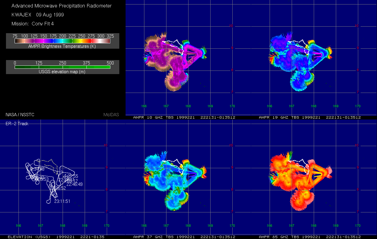
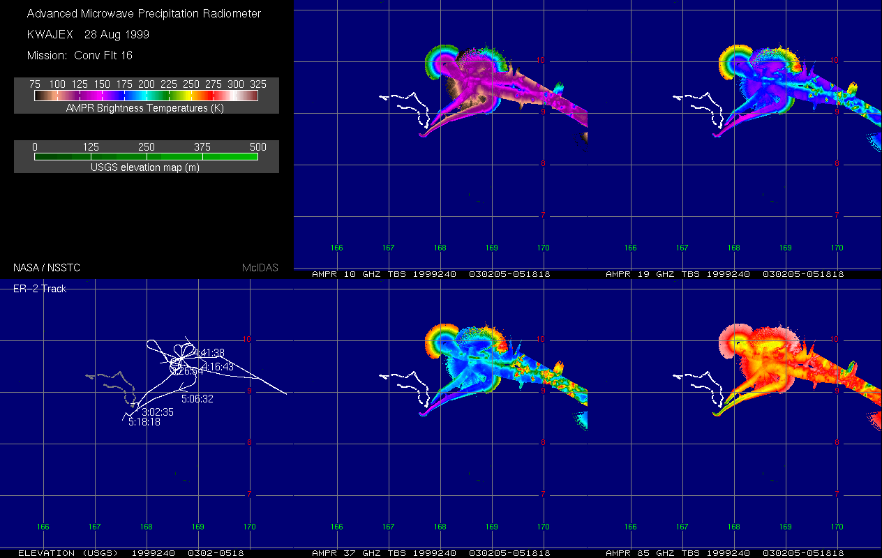
AMPR BRIGHTNESS TEMPERATURE (TB) KWAJEX V1
National Aeronautics and Space Administration —
The Advanced Microwave Precipitation Radiometer (AMPR) was deployed during the First Kwajelein Experiment (KWAJEX), which provided Ground Validation for instruments...

Official websites use .gov
A
.gov website belongs to an official government
organization in the United States.
Secure .gov websites use HTTPS
A
lock (
) or https:// means you’ve safely connected to
the .gov website. Share sensitive information only on official,
secure websites.