
-
Federal
Randomized and Recommissioned Battery Dataset
National Aeronautics and Space Administration —
An accelerated Life Testing Dataset for Lithium-Ion Batteries with Constant and Variable Loading Conditions We present an accelerated Li-ion battery life cycle... -
Federal
CMAPSS Jet Engine Simulated Data
National Aeronautics and Space Administration —
Data sets consists of multiple multivariate time series. Each data set is further divided into training and test subsets. Each time series is from a different engine... -
Federal
Global Distribution of Root Turnover in Terrestrial Ecosystems
National Aeronautics and Space Administration —
Estimates of root turnover rates were calculated from measurements of live root standing crop and belowground net primary production (BNPP) compiled from the primary... -
Federal
Flight Crew Physiological Data for Crew State Monitoring
National Aeronautics and Space Administration —
This physiological data was collected from pilot/copilot pairs in and out of a flight simulator. It was collected to train machine-learning models to aid in the... -
Federal
Land Use and Cover Maps from Landsat, Mawas, Central Kalimantan, Indonesia, 1994-2019
National Aeronautics and Space Administration —
This dataset contains annual land use/cover (LUC) maps at 30 m resolution across Mawas, Central Kalimantan, Indonesia. There are six files, each representing a five-... -
Federal
HIRENASD Experimental Data
National Aeronautics and Space Administration —
Experimental Data for HIRENASD configuration Zip files below contain the experimental data for the pressure coefficients, both the static and the forced oscillation... -
Federal
CERES and GEO-Enhanced TOA, Within-Atmosphere and Surface Fluxes, Clouds and Aerosols 3-Hourly Terra-Aqua Edition4A NGDA
National Aeronautics and Space Administration —
CER_SYN1deg-3Hour_Terra-Aqua-MODIS_Edition4A is the Clouds and the Earth's Radiant Energy System (CERES) and geostationary (GEO)-Enhanced Top of Atmosphere (TOA),... -
Federal
LUH1: Harmonized Global Land Use for Years 1500-2100, V1
National Aeronautics and Space Administration —
These data represent fractional land use and land cover patterns annually for the years 1500 - 2100 for the globe at 0.5-degree (~50-km) spatial resolution. Land use... -
Federal
LBA-ECO LC-04 Satellite/Census-Based 5-Minute Land Use Data, Amazonia: 1980 and 1995
National Aeronautics and Space Administration —
Amazonia has been under considerable development pressure as croplands and pasture are established in areas formerly occupied by tropical forest and cerrado. Although... -
Federal
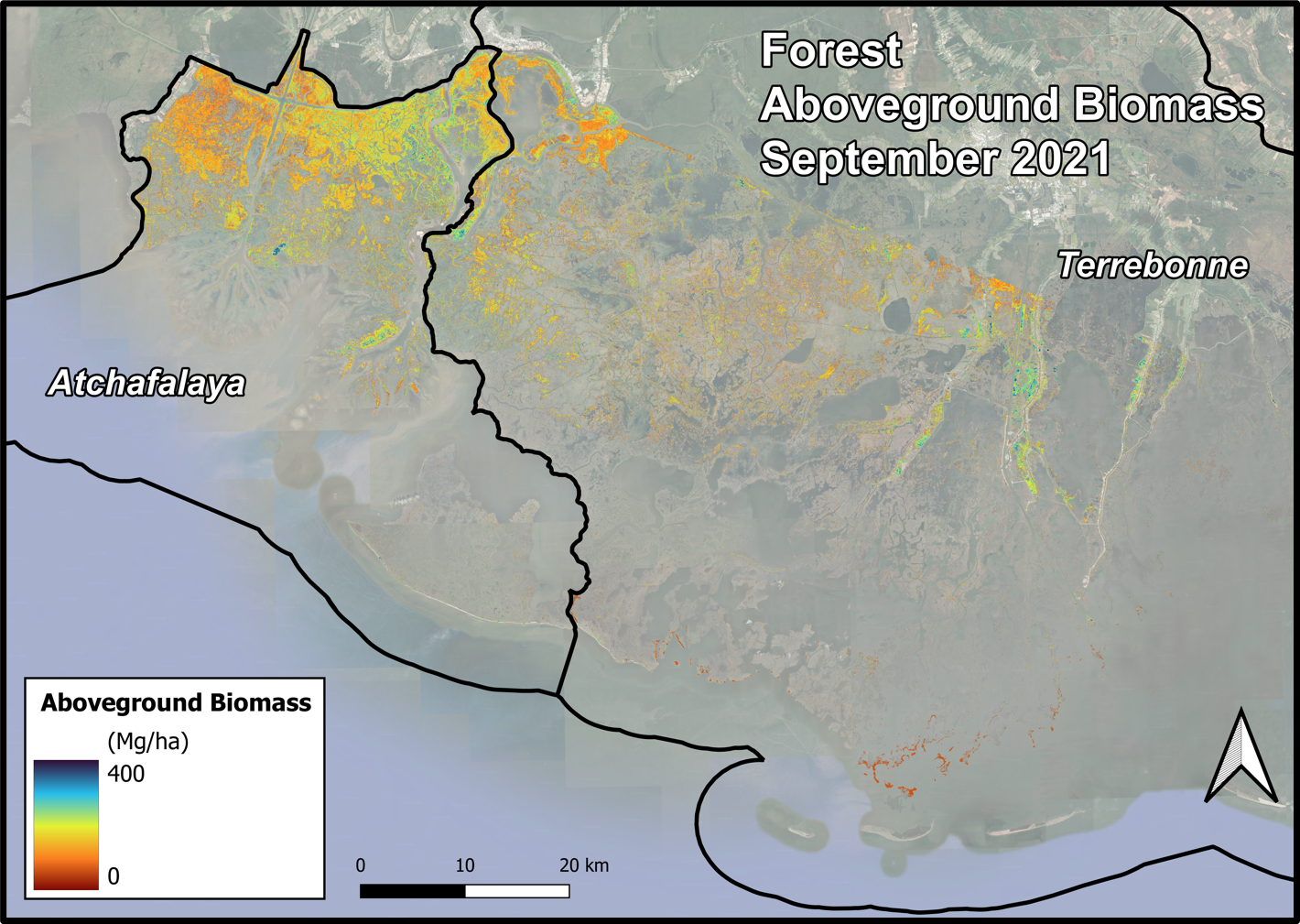
Delta-X AVIRIS-NG and UAVSAR L3 Derived Forest Aboveground Biomass, MRD, LA
National Aeronautics and Space Administration —
This dataset contains estimates of forest aboveground biomass (AGB) across the Atchafalaya and Terrebonne Basins, Louisiana, US. AGB was derived from AVIRIS-NG... -
Federal
Time-Based Flow Management Public SWIM
National Aeronautics and Space Administration —
This dataset contains raw messages received from the Time Based Flow Management (TBFM) System Wide Information System (SWIM) public data feed. This feed requires each... -
Federal
MASTER: Airborne Science, California-Nevada-New Mexico, May, 2002, V2
National Aeronautics and Space Administration —
This dataset includes Level 1B (L1B) data products from the MODIS/ASTER Airborne Simulator (MASTER) instrument. The spectral data were collected during seven flights... -
Federal
LBA-ECO CD-06 Carbon Cycling in Rivers in Amazonas and Acre, Brazil: 2005-2006
National Aeronautics and Space Administration —
This data set provides measured and calculated variables describing the carbon pools in river waters, CO2 respired from the water and total amount of CO2 evaded,... -
Federal
Eddy Corr. Surface Flux: USGS (FIFE)
National Aeronautics and Space Administration —
Surface flux measurements were made at selected sites within the FIFE area. Each surface flux station was capable of measuring the fluxes of net radiation, sensible... -
Federal
Randomized Battery Usage 5: High Temperature Right-Skewed Random Walk
National Aeronautics and Space Administration —
This dataset is part of a series of datasets, where batteries are continuously cycled with randomly generated current profiles. Reference charging and discharging... -
Federal
LBA-ECO TG-08 Trace Gas Fluxes from Wetted Forest and Pasture Soils, Rondonia, Brazil
National Aeronautics and Space Administration —
This data set includes the results of measurements of the soil gas fluxes of nitric oxide (NO), nitrous oxide (N2O), and carbon dioxide (CO2), soil moisture, soil... -
Federal
BOREAS RSS-17 Xylem Flux Density Measurements at the SSA-OBS Site
National Aeronautics and Space Administration —
As part of its efforts to determine environmental and phenological states from radar imagery, the BOREAS RSS-17 team collected in situ tree xylem flow measurements... -
Federal
SAFARI 2000 Stem and Canopy Characterization, Kalahari Transect, 1995-2000
National Aeronautics and Space Administration —
This data set provides species distribution, basal area, height, and crown cover of woody stems at 10 sites along the Kalahari Transect where a large gradient in both... -
Federal
LBA-ECO CD-08 Radiocarbon Dates for Large Trees from a Forest near Manaus, Brazil
National Aeronautics and Space Administration —
This data set reports the ages and growth rates of trees as determined by radiocarbon dating (14C), selected from a logging operation near the city of Itacoatiara,...

Official websites use .gov
A
.gov website belongs to an official government
organization in the United States.
Secure .gov websites use HTTPS
A
lock (
) or https:// means you’ve safely connected to
the .gov website. Share sensitive information only on official,
secure websites.