
-
Federal
NASA Ocean Biogeochemical Model assimilating satellite chlorophyll data global monthly VR2017 (NOBM_MON) at GES DISC
National Aeronautics and Space Administration —
This is the assimilated monthly data from NASA Ocean Biogeochemical Model (NOBM). The NOBM is a comprehensive, interactive ocean biogeochemical model coupled with a... -
Federal
EMIT L2B Estimated Mineral Identification and Band Depth and Uncertainty 60 m V001
National Aeronautics and Space Administration —
The Earth Surface Mineral Dust Source Investigation (EMIT) instrument measures surface mineralogy, targeting the Earth’s arid dust source regions. EMIT is installed... -
Federal
MODIS/Terra+Aqua Direct Broadcast Burned Area Monthly L3 Global 500m SIN Grid V006
National Aeronautics and Space Administration —
The MCD64A1 Version 6 data product was decommissioned on July 31, 2023. Users are encouraged to use the MCD64A1 Version 6.1 data product.The Terra and Aqua combined... -
Federal
MODIS/Terra Vegetation Indices Monthly L3 Global 1km SIN Grid V061
National Aeronautics and Space Administration —
The Terra Moderate Resolution Imaging Spectroradiometer (MODIS) Vegetation Indices Monthly (MOD13A3) Version 6.1 data are provided monthly at 1 kilometer (km) spatial... -
Federal
Third International Diagnostic Competition
National Aeronautics and Space Administration —
We present the third implementation of a framework created jointly by NASA Ames Research Center, Palo Alto Research Center, and Delft University of Technology to com-... -
Federal
Aviation Safety Reporting System: Commuter and Corporate Flight Crew Fatigue Reports
National Aeronautics and Space Administration —
A sampling of reports referencing Commuter and Corporate flight crew fatigue issues and duty periods. -
Federal
RTA & IFASD June-July 2011
National Aeronautics and Space Administration —
Information that was shared at the meetings held in Paris is located in this resource page Paper that was published in magazine is linked directly -
Federal
Qualitative Event-based Diagnosis with Possible Conflicts: Case Study on the Third International Diagnostic Competition
National Aeronautics and Space Administration —
We describe two model-based diagnosis algo- rithms entered into the Third International Diag- nostic Competition. We focus on the first diag- nostic problem of the... -
Federal
Global Gridded Surfaces of Selected Soil Characteristics (IGBP-DIS)
National Aeronautics and Space Administration —
The Global Gridded Surfaces of Selected Soil Characteristics (IGBP-DIS) data set contains 7 data surfaces: soil-carbon density, total nitrogen density, field... -
Federal
Combined ASTER and MODIS Emissivity database over Land (CAMEL) Emissivity Monthly Global 0.05Deg V001
National Aeronautics and Space Administration —
The CAM5K30EM.001 dataset was decommissioned as of March 14, 2019. Users are encouraged to use the new improved CAM5K30EM.003 dataset.The NASA Making Earth System... -
Federal
LPJ-PROSAIL L2 Global Simulated Dynamic Surface Reflectance V002
National Aeronautics and Space Administration —
LPJ-PROSAIL simulated data products are produced through the coupling of the Lund-Potsdam-Jena dynamic global vegetation model (LPJ) and PROSAIL, a radiative transfer... -
Federal
VEMAP 2: U.S. Monthly Climate, 1895-1993, Version 2
National Aeronautics and Space Administration —
The Vegetation/Ecosystem Modeling and Analysis Project (VEMAP) Phase 2 has developed a data set of ~100-year gridded monthly and daily time series of climate for the... -
Federal
UC Berkeley CYGNSS Level 3 Monthly RWAWC Watermask Version 3.1
National Aeronautics and Space Administration —
The CYGNSS Level 3 UC Berkeley Watermask Record Version 3.1 was developed by CYGNSS investigators in the Department of Civil and Environmental Engineering at the... -
Federal
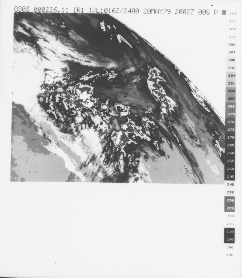
VISSR/GOES-3 Infrared Imagery on 70mm Film V001 (VISSRGOES3IMIR) at GES DISC
National Aeronautics and Space Administration —
VISSRGOES3IMIR is the Visible Infrared Spin-Scan Radiometer (VISSR) Infrared Imagery on 70mm Film data product from the third Geostationary Operational Environmental... -
Federal
TES/Aura L3 Carbon Monoxide Monthly Gridded V006
National Aeronautics and Space Administration —
TL3COM_6 is the Tropospheric Emission Spectrometer (TES)/Aura Level 3 Carbon Monoxide Monthly Gridded Version 6 data product. TES was an instrument aboard NASA's Aura... -
Federal
TransCom 3: Annual Mean CO2 Flux Estimates from Atmospheric Inversions (Level 1)
National Aeronautics and Space Administration —
The Atmospheric Tracer Transport Model Intercomparison Project (TransCom) was created to quantify and diagnose the uncertainty in inversion calculations of the global... -
Federal
SiB3 Modeled Global 1-degree Hourly Biosphere-Atmosphere Carbon Flux, 1998-2006
National Aeronautics and Space Administration —
The Simple Biosphere Model, Version 3 (SiB3) was used to produce a global data set of hourly carbon fluxes between the atmosphere and the terrestrial biosphere for... -
Federal
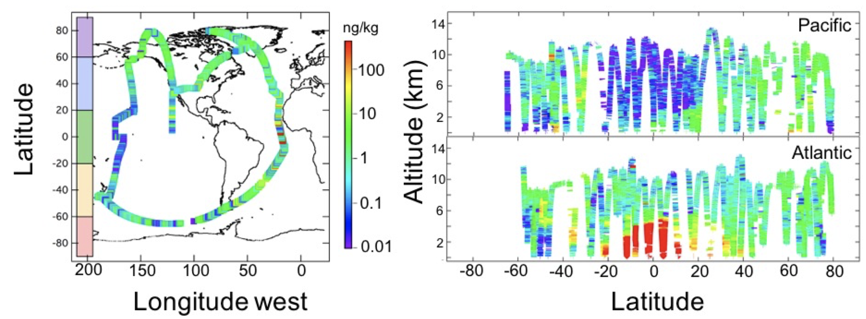
ATom: Black Carbon Mass Mixing Ratios from ATom-1 Flights
National Aeronautics and Space Administration —
This dataset provides black carbon (BC) mass mixing ratios (in units of ng BC / kg air) measured during NASA's Atmospheric Tomography (ATom)-1 flight campaign during... -
Federal
BOREAS RSS-02 Extracted Reflectance Factors Derived from ASAS Imagery
National Aeronautics and Space Administration —
Atmospherically-corrected bidirectional reflectance factor means for small homogeneous areas from several BOREAS sites were derived from multi-spectral, multi-angle... -
Federal
BARREL 1J Data Processing Unit (HKPG) Analog Housekeeping Voltage, Temperature, Current, and Payload Status, Level 2, 40 s Data
National Aeronautics and Space Administration —
Housekeeping voltage, temperature, current, and payload status values returned every 40 s. NOTE: The analog sensor data in these records are based on the nominal...

Official websites use .gov
A
.gov website belongs to an official government
organization in the United States.
Secure .gov websites use HTTPS
A
lock (
) or https:// means you’ve safely connected to
the .gov website. Share sensitive information only on official,
secure websites.