
-
Federal
Distribution of Estimated Stand Age Across Siberian Larch Forests, 1989-2012
National Aeronautics and Space Administration —
This data set provides mapped estimates of the stand age of young (less than 25 years old) larch forests across Siberia from 1989-2012 at 30-m resolution. The age... -
Federal
VIIRS/JPSS1 BRDF/Albedo Parameter 2 Band M8 Daily L3 Global 30 ArcSec CMG V002
National Aeronautics and Space Administration —
The NOAA-20 Visible Infrared Imaging Radiometer Suite (VIIRS) Bidirectional Reflectance Distribution Function (BRDF) and Albedo Model Parameter 2 Band M8 product... -
Federal
BOREAS AFM-06 Boundary Layer Height Data
National Aeronautics and Space Administration —
The BOREAS AFM-06 team from the National Oceanic and Atmospheric Administration Environment Technology Laboratory (NOAA/ETL) operated a 915 MHz wind/Radio Acoustic... -
Federal
VIIRS/JPSS1 BRDF/Albedo NBAR at Solar Noon Band M8 Daily L3 Global 30ArcSec CMG V002
National Aeronautics and Space Administration —
The NOAA-20 Visible Infrared Imaging Radiometer Suite (VIIRS) Bidirectional Reflectance Distribution Function (BRDF) and Albedo Nadir BRDF-Adjusted Reflectance (NBAR)... -
Federal
LBA-ECO CD-36 South American Land Data Assimilation System Atmospheric Forcing Data
National Aeronautics and Space Administration —
This data set provides South American Land Data Assimilation System (SALDAS) forcing data including atmospheric fields necessary for land surface modeling for South... -
Federal
MLS/Aura Level 3 Daily Binned Sulfur Dioxide (SO2) Mixing Ratio on Assorted Grids V005 (ML3DBSO2) at GES DISC
National Aeronautics and Space Administration —
ML3DBSO2 is the EOS Aura Microwave Limb Sounder (MLS) daily binned on various vertical grids product for sulfur dioxide (SO2) derived from radiances measured by the... -
Federal
VIIRS/JPSS1 BRDF/Albedo Parameter 1 Band M8 Daily L3 Global 30 ArcSec CMG V002
National Aeronautics and Space Administration —
The NOAA-20 Visible Infrared Imaging Radiometer Suite (VIIRS) Bidirectional Reflectance Distribution Function (BRDF) and Albedo Model Parameter 1 Band M8 product... -
Federal
VIIRS/JPSS1 BRDF/Albedo WSA at Solar Noon Band M8 Daily L3 Global 30ArcSec CMG V002
National Aeronautics and Space Administration —
The NOAA-20 Visible Infrared Imaging Radiometer Suite (VIIRS) Bidirectional Reflectance Distribution Function (BRDF) and Albedo white-sky albedo for band M8... -
Federal
VEMAP 2: U.S. Monthly Climate Change Scenarios, Version 2
National Aeronautics and Space Administration —
The Vegetation/Ecosystem Modeling and Analysis Project (VEMAP) Phase 2 has developed a number of transient climate change scenarios based on coupled atmosphere-ocean... -
Federal
VIIRS/JPSS1 BRDF/Albedo Parameter 3 Band M8 Daily L3 Global 30 ArcSec CMG V002
National Aeronautics and Space Administration —
The NOAA-20 Visible Infrared Imaging Radiometer Suite (VIIRS) Bidirectional Reflectance Distribution Function (BRDF) and Albedo Model Parameter 3 Band M8 product... -
Federal
SAFARI 2000 Upper Air Meteorological Profiles, South Africa, Dry Season 2000
National Aeronautics and Space Administration —
The University of Wyoming has a series of balloonborne radiosonde measurements from all around the world, from the surface to 30 km. This data set contains upper air... -
Federal
VIIRS/NPP BRDF/Albedo WSA at Solar Noon Band M8 Daily L3 Global 30ArcSec CMG V002
National Aeronautics and Space Administration —
The NASA/NOAA Suomi National Polar-orbiting Partnership (Suomi NPP) Visible Infrared Imaging Radiometer Suite (VIIRS) Bidirectional Reflectance Distribution Function... -
Federal
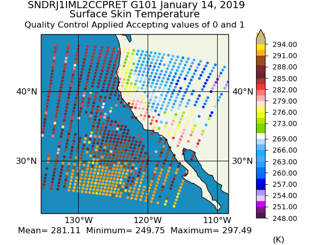
Sounder SIPS: JPSS-1 CrIS Level 2 CLIMCAPS: Atmosphere cloud and surface geophysical state V2 (SNDRJ1IML2CCPRET) at GES DISC
National Aeronautics and Space Administration —
WARNING: To users of the derived product “co_mmr_midtrop” (carbon monoxide mass mixing ratio to dry air [kg/kg] at ~500 hPa). This variable has a significant bias due... -
Federal
Sounder SIPS: JPSS-1 CrIMSS Level 2 CLIMCAPS: retrieved atmospheric state V2.1 (SNDRJ1IML2CPS) at GES DISC
National Aeronautics and Space Administration —
The CLIMCAPS (Community Long-term Infrared Microwave Coupled Product System) algorithm is used to analyze data from the Cross-track Infrared Sounder/Advanced... -
Federal
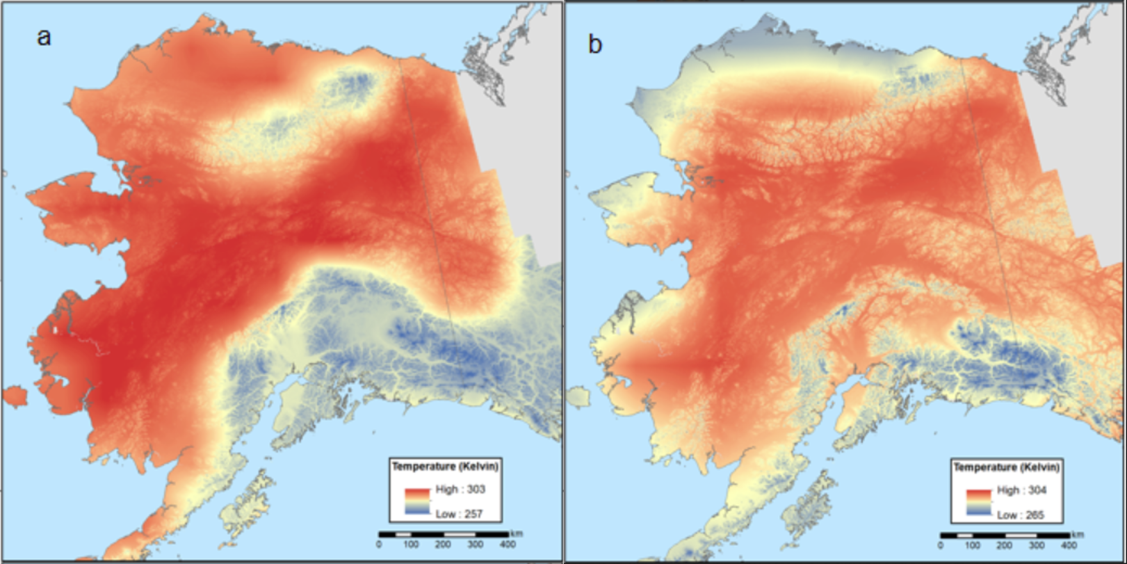
Climate Normals for Last Glacial Maximum and Modern (1975-2005), Alaska
National Aeronautics and Space Administration —
This dataset provides two 30-year climate normal data products for conditions during the last glacial maximum (LGM; ~18,000 years ago) and a modern time period... -
Federal
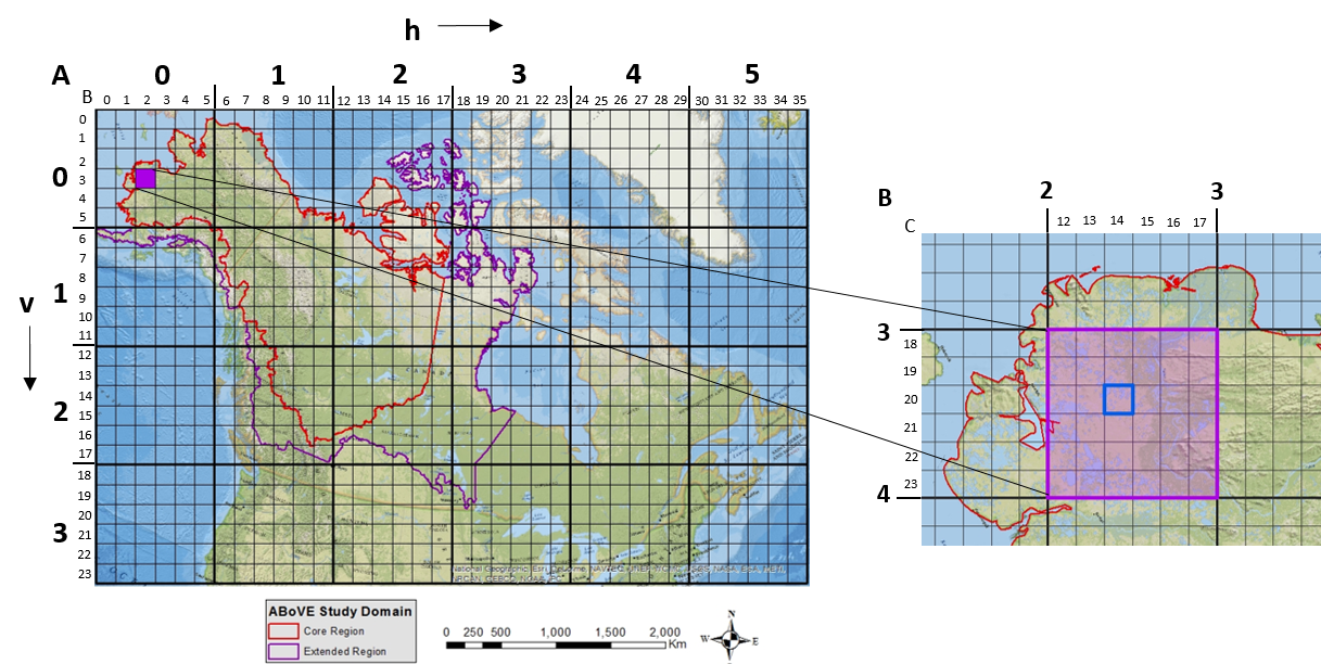
ABoVE: Study Domain and Standard Reference Grids, Version 2
National Aeronautics and Space Administration —
The Arctic - Boreal Vulnerability Experiment (ABoVE) has developed two standardized spatial data products to expedite coordination of research activities and to... -
Federal
BOREAS TGB-12 Soil Carbon and Flux Data of NSA-MSA in Raster Format
National Aeronautics and Space Administration —
The BOREAS TGB-12 team made measurements of soil carbon inventories, carbon concentration in soil gases, and rates of soil respiration at several sites. This data set... -
Federal
CMS: Mangrove Canopy Height Estimates from Remote Imagery, Zambezi Delta, Mozambique
National Aeronautics and Space Administration —
This data set provides high resolution canopy height estimates for mangrove forests in the Zambezi Delta, Mozambique, Africa. The estimates were derived from three... -
Federal
Sounder SIPS: Suomi NPP CrIMSS Level 2 CLIMCAPS Full Spectral Resolution: Atmosphere cloud and surface geophysical state V2 (SNDRSNIML2CCPRET) at GES DISC
National Aeronautics and Space Administration —
WARNING: To users of the derived product “co_mmr_midtrop” (carbon monoxide mass mixing ratio to dry air [kg/kg] at ~500 hPa). This variable has a significant bias due...

Official websites use .gov
A
.gov website belongs to an official government
organization in the United States.
Secure .gov websites use HTTPS
A
lock (
) or https:// means you’ve safely connected to
the .gov website. Share sensitive information only on official,
secure websites.