
-
Federal
HAQAST Sentinel-5P TROPOMI Nitrogen Dioxide (NO2) GLOBAL Monthly Level 3 0.1 x 0.1 Degree Gridded Data Version 2.4 (HAQ_TROPOMI_NO2_GLOBAL_M_L3) at GES DISC
National Aeronautics and Space Administration —
This product provides level 3 monthly averages of tropospheric Nitrogen dioxide (NO2) vertical column density derived from the level 2 Tropospheric Monitoring... -
Federal
Spatial Data from the 2011 India Census
National Aeronautics and Space Administration —
The Spatial Data from the 2011 India Census contains gridded estimates of India population at a resolution of 1 kilometer along with two spatial renderings of urban... -
Federal
Annual PM2.5 Concentrations for Countries and Urban Areas, 1998-2016 NGDA
National Aeronautics and Space Administration —
The Annual PM2.5 Concentrations for Countries and Urban Areas, 1998-2016, consists of mean concentrations of particulate matter (PM2.5) for countries and urban areas.... -
Federal
HAQAST Sentinel-5P TROPOMI Nitrogen Dioxide (NO2) CONUS Monthly Level 3 0.01 x 0.01 Degree Gridded Data V2.4 (HAQ_TROPOMI_NO2_CONUS_M_L3) at GES DISC
National Aeronautics and Space Administration —
This product provides level 3 monthly averages of tropospheric Nitrogen dioxide (NO2) vertical column density derived from the level 2 Tropospheric Monitoring... -
Federal
West Africa Coastal Vulnerability Mapping: Population Projections, 2030 and 2050
National Aeronautics and Space Administration —
The West Africa Coastal Vulnerability Mapping: Population Projections, 2030 and 2050 data set is based on an unreleased working version of the Gridded Population of... -
Federal
West Africa Coastal Vulnerability Mapping: Social Vulnerability Indices
National Aeronautics and Space Administration —
The West Africa Coastal Vulnerability Mapping: Social Vulnerability Indices data set includes three indices: Social Vulnerability, Population Exposure, and Poverty... -
Federal
MODIS/Aqua Aerosol 5-Min L2 Swath 10km
National Aeronautics and Space Administration —
The MODIS/Aqua Aerosol 5-Min L2 Swath 10km product (MYD04_L2) provides full global coverage of aerosol properties from the Dark Target (DT) and Deep Blue (DB)... -
Federal
China Dimensions Data Collection: Fundamental GIS: Digital Chart of China, 1:1M, Version 1
National Aeronautics and Space Administration —
The Fundamental GIS: Digital Chart of China, 1:1M, Version 1 consists of vector maps of China and surrounding areas. The maps include roads, railroads, drainage... -
Federal
Low Elevation Coastal Zone (LECZ) Urban-Rural Population and Land Area Estimates, Version 3
National Aeronautics and Space Administration —
The Low Elevation Coastal Zone (LECZ) Urban-Rural Population and Land Area Estimates, Version 3 data set contains land areas with urban, quasi-urban, rural, and total... -
Federal
Annual Mean PM2.5 Components (EC, NH4, NO3, OC, SO4) 50m Urban and 1km Non-Urban Area Grids for Contiguous U.S., 2000-2019 v1
National Aeronautics and Space Administration —
The Annual Mean PM2.5 Components (EC, NH4, NO3, OC, SO4) 50m Urban and 1km Non-Urban Area Grids for Contiguous U.S., 2000-2019, v1 data set contains annual... -
Federal
MODIS/Terra Aerosol 5-Min L2 Swath 10km
National Aeronautics and Space Administration —
The MODIS/Terra Aerosol 5-Min L2 Swath 10km (MOD04_L2) product provides full global coverage of aerosol properties from the Dark Target (DT) and Deep Blue (DB)... -
Federal
MODIS/Aqua Aerosol 5-Min L2 Swath 3km
National Aeronautics and Space Administration —
The new Collection 6.1 (C61) MODIS/Aqua Aerosol 5 Min L2 Swath 3km (MYD04_3K) product is an improved version based on algorithm changes in Dark Target (DT) Aerosol... -
Federal
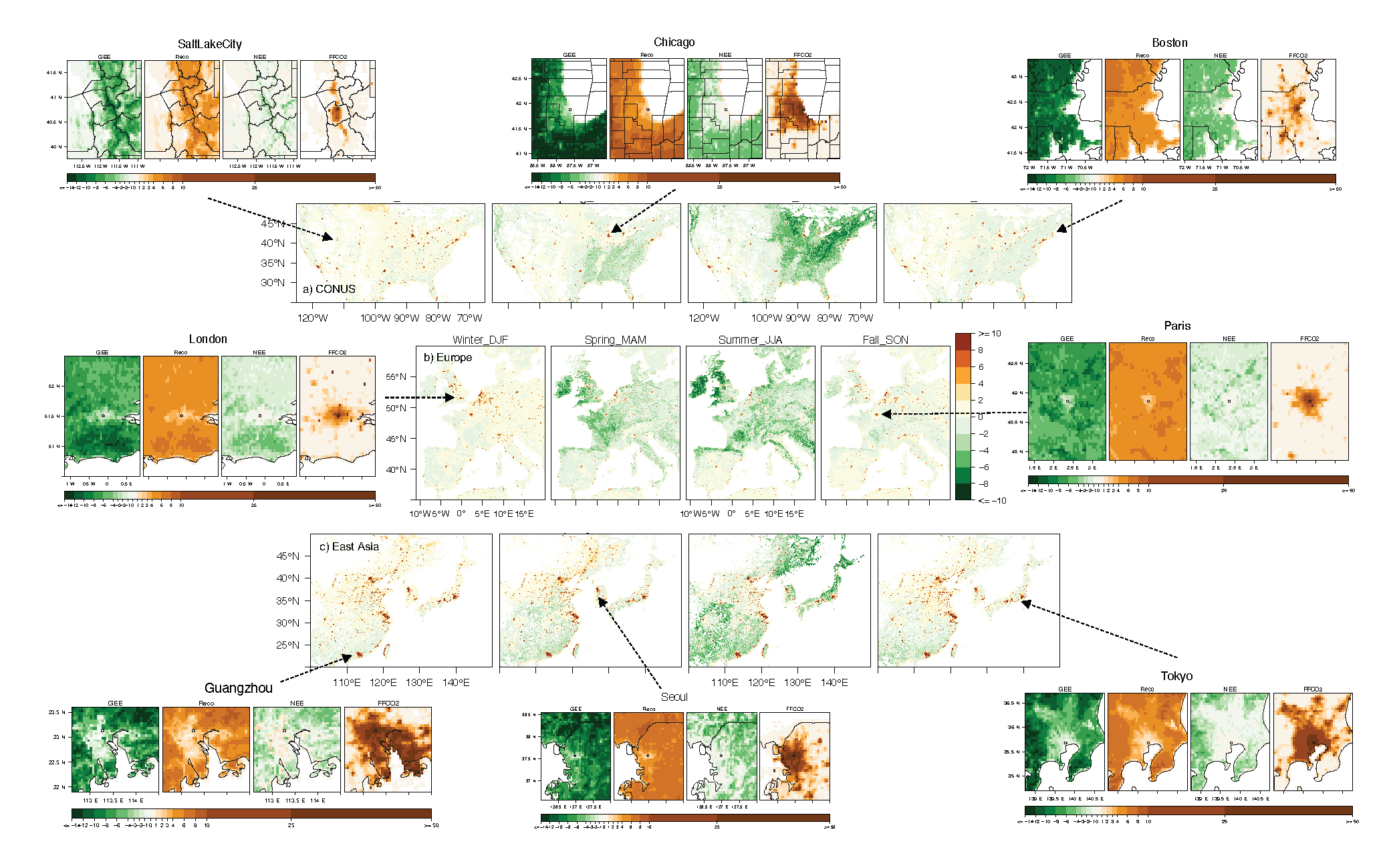
Urban Biogenic CO2 fluxes: GPP, Reco and NEE Estimates from SMUrF, 2010-2019
National Aeronautics and Space Administration —
This dataset contains estimates of biogenic CO2 flux components at 0.05 degree resolution from the Solar-Induced Fluorescence (SIF) for Modeling Urban biogenic Fluxes... -
Federal
Sources of Methane Emissions (Vista-CA), State of California, USA
National Aeronautics and Space Administration —
This dataset provides spatial data products with identified and organized locations of potential methane (CH4) emitting facilities and infrastructure spanning the... -
Federal
STAQS NASA G-III GEOstationary Coastal and Air Pollution Events (GEO-CAPE) Airborne Simulator Data
National Aeronautics and Space Administration —
STAQS_AircraftRemoteSensing_NASA-G3_GCAS_Data is the remotely sensed trace gas data for the NASA Gulfstream III aircraft taken by the GEOstationary Coastal and Air... -
Federal
Annual Mean PM2.5 Components Trace Elements (TEs) 50m Urban and 1km Non-Urban Area Grids for Contiguous U.S., 2000-2019, v1
National Aeronautics and Space Administration —
The Annual Mean PM2.5 Components Trace Elements (TEs) 50m Urban and 1km Non-Urban Area Grids for Contiguous U.S., 2000-2019, v1 data set contains annual predictions... -
Federal
STAQS Balloonsondes and Ozonesondes Data
National Aeronautics and Space Administration —
STAQS_Sondes_Data is the balloonsonde and ozonesonde data collected during the Synergistic TEMPO Air Quality Science (STAQS) mission. Data collection for this product... -
Federal
HAQAST Sentinel-5P TROPOMI Nitrogen Dioxide (NO2) GLOBAL Annual Level 3 0.1 x 0.1 Degree Gridded Data Version 2.4 (HAQ_TROPOMI_NO2_GLOBAL_A_L3) at GES DISC
National Aeronautics and Space Administration —
This product provides level 3 annual averages of tropospheric Nitrogen dioxide (NO2) vertical column density derived from the level 2 Tropospheric Monitoring... -
Federal
STAQS Drone Data
National Aeronautics and Space Administration —
STAQS_Drone_Data is the PM 2.5 data collected by the BlueHalo E900 UAV during the Synergistic TEMPO Air Quality Science (STAQS) mission. Data collection for this...

Official websites use .gov
A
.gov website belongs to an official government
organization in the United States.
Secure .gov websites use HTTPS
A
lock (
) or https:// means you’ve safely connected to
the .gov website. Share sensitive information only on official,
secure websites.