
-
Federal
Global Forest Ecosystem Structure and Function Data For Carbon Balance Research
National Aeronautics and Space Administration —
A comprehensive global database has been assembled to quantify CO2 fluxes and pathways across different levels of integration (from photosynthesis up to net ecosystem... -
Federal
AVIRIS-NG L2 Surface Reflectance, Facility Instrument Collection, V1
National Aeronautics and Space Administration —
This dataset contains Level 2 (L2) orthocorrected reflectance from the Airborne Visible / Infrared Imaging Spectrometer-Next Generation (AVIRIS-NG) instrument. This... -
Federal
LBA-ECO CD-03 Cloud Base-Backscatter Data, km 67 Tower Site, Tapajos National Forest
National Aeronautics and Space Administration —
A Vaisala CT-25K ceilometer was installed at an old-growth forest site located at the km 67 Eddy Flux Tower site in the Tapajos National Forest, Para, Brazil, off... -
Federal
Global 30-Year Mean Monthly Climatology, 1901-1960 (New et al.)
National Aeronautics and Space Administration —
A data set of 30-year mean monthly surface climate over global land areas, excluding Antarctica. Interpolated from station data to 0.5 degree lat/lon for a range of... -
Federal
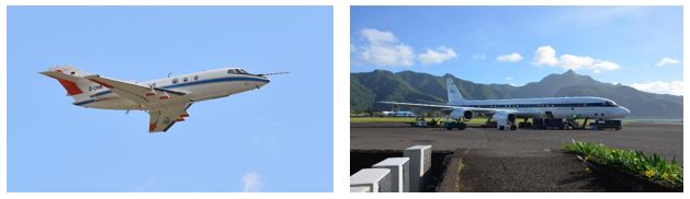
SAFARI 2000 C-130 Aerosol and Meteorological Data, Dry Season 2000
National Aeronautics and Space Administration —
The Met Office C-130 research aircraft was based at Windhoek, Namibia, between September 5-16, 2000, where it conducted a series of flights over Namibia as part of... -
Federal
ISLSCP II Surface Radiation Budget (SRB) Radiation Data
National Aeronautics and Space Administration —
This data set contains global Surface Radiation Budget (SRB) and a few top-of-atmosphere (TOA) radiation budget parameters on a 1-degree x 1-degree spatial... -
Federal
Global Monthly Climatology for the Twentieth Century (New et al.)
National Aeronautics and Space Administration —
A 0.5 degree lat/lon data set of monthly surface climate over global land areas, excluding Antarctica. Primary variables are interpolated directly from station time-... -
Federal
SAFARI 2000 MAPSS MOD04_L2 Aerosol Summary Data for Southern Africa NGDA
National Aeronautics and Space Administration —
The MODIS (Moderate Resolution Imaging Spectroradiometer) Atmosphere Group develops remote sensing algorithms for deriving sets of atmospheric parameters from MODIS... -
Federal
ISLSCP II Climate Research Unit CRU05 Monthly Climate Data
National Aeronautics and Space Administration —
This data set contains a mean monthly climatology for several climate variables averaged over the period from 1961 to 1990, and constructed from a data set of station... -
Federal
AMAZE-08 Aerosol Characterization and Meteorological Data, Central Amazon Basin: 2008
National Aeronautics and Space Administration —
This data set provides measurements from the Amazonian Aerosol Characterization Experiment (AMAZE-08) carried out during the wet season from February 4 to March 21,... -
Federal
SAFARI 2000 Micro-Pulse Lidar Cloud and Aerosol Data, Dry Season 2000
National Aeronautics and Space Administration —
Two Micro-Pulse Lidar (MPL) systems were deployed to Africa for the SAFARI 2000 experiment. One MPL was set up in Mongu, Zambia, and the other was set up in Skukuza,... -
Federal
ATom: In-Situ Measurements of Airflow and Aerosols from Multiple Airborne Campaigns
National Aeronautics and Space Administration —
This dataset provides results of selected in-situ measurements of airflow and aerosol particles collected during the following airborne campaigns: NASA Atmospheric... -
Federal
ATom: Global Modeled and CAFS Measured Cloudy and Clear Sky Photolysis Rates, 2016
National Aeronautics and Space Administration —
This dataset provides the results from nine global chemistry-climate or chemistry-transport models that estimated gridded values of atmospheric photolytic rates (J... -
Federal
ACT-America: CPL-derived Atmospheric Boundary Layer Top Height, Eastern US, 2016-2018
National Aeronautics and Space Administration —
This dataset consists of the atmospheric boundary layer (ABL) top heights and the altitudes of the two additional aerosol layers (in km above mean sea level) derived... -
Federal
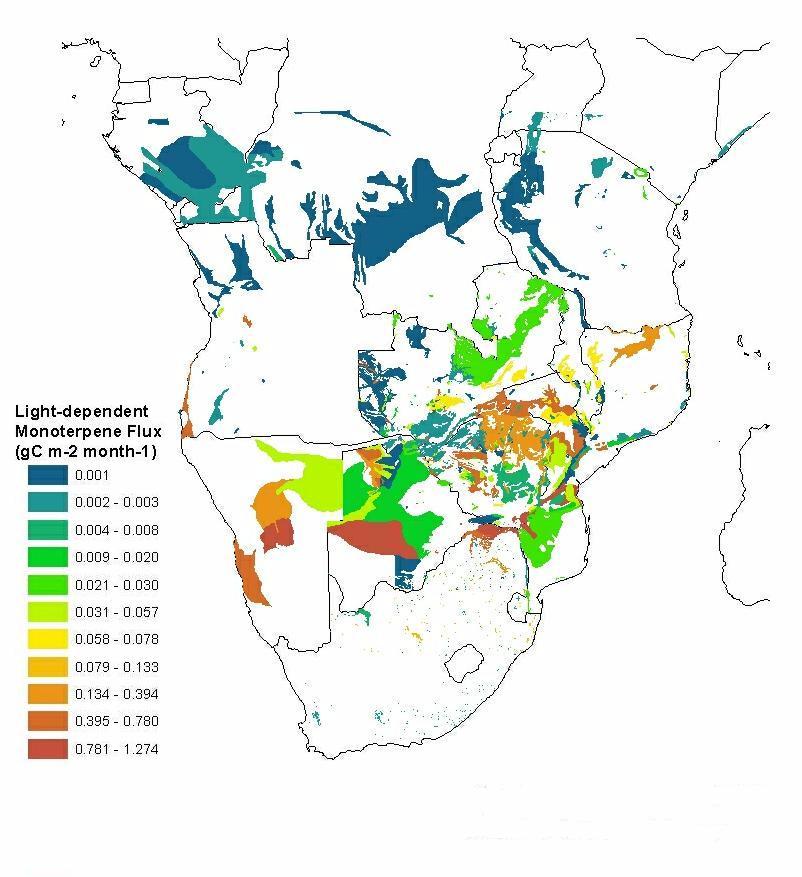
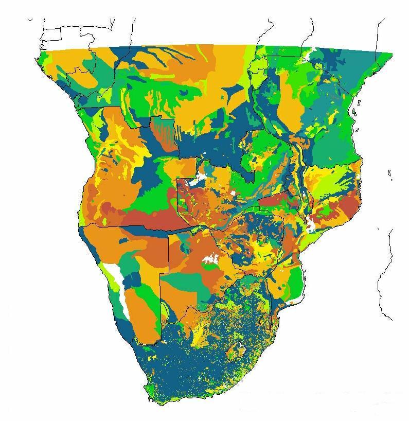
SAFARI 2000 Estimated BVOC Emissions for Southern African Land Cover Types NGDA
National Aeronautics and Space Administration —
Improved vegetation distribution and emission data for Africa south of the equator were developed for the Southern African Regional Science Initiative (SAFARI 2000)... -
Federal
BOREAS/AES READAC 15-minute Surface Meteorological Data
National Aeronautics and Space Administration —
Contains 15 minute surface meteorology data collected during the 1994 field campaigns by the Atmospheric Environment Service Remote Environmental Automatic Data... -
Federal
SAFARI 2000 ETA Atmospheric Model Data, Wet and Dry Seasons 2000
National Aeronautics and Space Administration —
With modern computer power now capable of making mesoscale model output available in real time in the operational environment, increased attention has been given to... -
Federal
SAFARI 2000 TOVS Surface and Atmospheric Parameters, 1-Deg, 1999-2001
National Aeronautics and Space Administration —
NOAA's TIROS (Television Infrared Observation Satellite) Operational Vertical Sounder (TOVS) is a suite of three sensors: the Microwave Sounding Unit (MSU), the High... -
Federal
ISLSCP II CRU05 Climate Time Series for Global Land Areas, 1986-1995
National Aeronautics and Space Administration —
This data set contains monthly climate time series data created by the Climatic Research Unit (CRU) at the University of East Anglia, U.K.,for every year covering the... -
Federal
BOREAS AES Canadian Hourly and Daily Surface Meteorological Data, R1
National Aeronautics and Space Administration —
This data set contains hourly and daily meteorological data from 23 meteorological stations across Canada from January 1975 to January 1997. The surface meteorology...

Official websites use .gov
A
.gov website belongs to an official government
organization in the United States.
Secure .gov websites use HTTPS
A
lock (
) or https:// means you’ve safely connected to
the .gov website. Share sensitive information only on official,
secure websites.