
-
Federal
LiDAR Surveys over Selected Forest Research Sites, Brazilian Amazon, 2008-2018
National Aeronautics and Space Administration —
This dataset provides the complete catalog of point cloud data collected during LiDAR surveys over selected forest research sites across the Amazon rainforest in... -
Federal
Global 1-km Gridded Thickness of Soil, Regolith, and Sedimentary Deposit Layers
National Aeronautics and Space Administration —
This data set provides high-resolution estimates of the thickness of the permeable layers above bedrock (soil, regolith, and sedimentary deposits) within a global... -
Federal
NACP Aboveground Biomass and Carbon Baseline Data, V.2 (NBCD 2000), U.S.A., 2000
National Aeronautics and Space Administration —
The NBCD 2000 (National Biomass and Carbon Dataset for the Year 2000) data set provides a high-resolution (30 m) map of year-2000 baseline estimates of basal area-... -
Federal
Delta-X: Digital Elevation Model, MRD, LA, USA, 2021
National Aeronautics and Space Administration —
This dataset provides an updated digital elevation model (DEM) for the Atchafalaya and Terrebonne basins in coastal Louisiana, USA. The DEM is updated from the Pre-... -
Federal
ABoVE: Permafrost Measurements and Distribution Across the Y-K Delta, Alaska, 2016
National Aeronautics and Space Administration —
This dataset provides field observations of thaw depth and dominant vegetation types, a LiDAR-derived elevation map, and permafrost distribution and probability maps... -
Federal
Annual Land Use and Urban Land Cover: Ethiopia, Nigeria, and South Africa, 2016-2020
National Aeronautics and Space Administration —
This dataset provides a two-tier annual Land Use (LU) and Urban Land Cover (LC) product suite over three African countries, Ethiopia, Nigeria, and South Africa,... -
Federal
GEDI L3 Gridded Land Surface Metrics, Version 1
National Aeronautics and Space Administration —
This dataset provides Global Ecosystem Dynamics Investigation (GEDI) Level 3 (L3) gridded mean canopy height, standard deviation of canopy height, mean ground... -
Federal
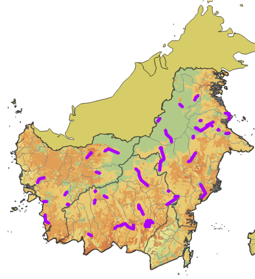
CMS: LiDAR Data for Forested Sites on Borneo Island, Kalimantan, Indonesia, 2014
National Aeronautics and Space Administration —
This dataset provides airborne LiDAR data collected over 90 sites totaling approximately 100,000 hectares of forested land in Kalimantan, Indonesia on the island of... -
Federal
Carbon Pools across CONUS using the MaxEnt Model, 2005, 2010, 2015, 2016, and 2017
National Aeronautics and Space Administration —
This dataset provides annual estimates of six carbon pools, including forest aboveground live biomass, belowground biomass, aboveground dead biomass, belowground dead... -
Federal
Multispectral Imagery, NDVI, and Terrain Models, Big Trail Lake, Fairbanks, AK, 2019
National Aeronautics and Space Administration —
This dataset provides multispectral reflectance imagery (green at 550 nm, red at 660 nm, red edge at 735 nm, and near-infrared at 790 nm), normalized difference... -
Federal
LBA-ECO CD-06 Amazon River Basin Land and Stream Drainage Direction Maps
National Aeronautics and Space Administration —
This data set provides high-resolution (~500 m) gridded land and stream drainage direction maps for the Amazon River basin, excluding the Rio Tocantins basin. These... -
Federal
NPP Multi-Biome: Summary Data from Intensive Studies at 125 Sites, 1936-2006
National Aeronautics and Space Administration —
This data set, NPP Multi-Biome: Summary Data from Intensive Studies at 125 Sites, 1936-2006, contains a single shapefile that provides site-level summary statistics... -
Federal
VEMAP 1: Georeferencing
National Aeronautics and Space Administration —
The Vegetation/Ecosystem Modeling and Analysis Project (VEMAP) is an ongoing multiinstitutional, international effort addressing the response of biogeography and... -
Federal
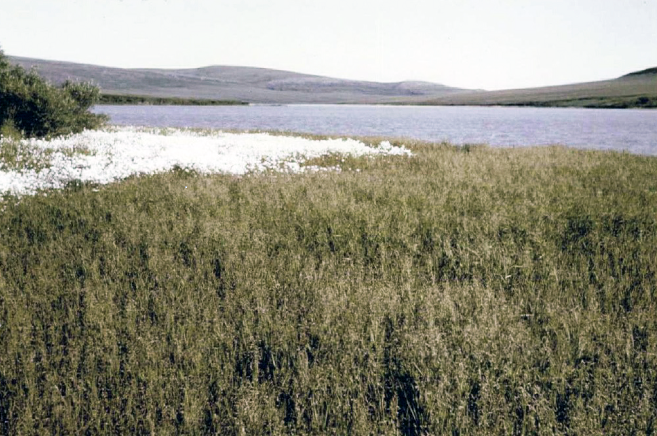
Arctic Vegetation Plots in Northern NWT and YT, Canada, 1965-1966
National Aeronautics and Space Administration —
This dataset provides vegetation, soil, and plot characteristics for 154 study plots located at three sites across the Richardson Mountains, Northwest Territories... -
Federal
LBA-ECO LC-01 SRTM 90-Meter Digital Elevation Model, Northern Ecuadorian Amazon
National Aeronautics and Space Administration —
This data set provides 90-meter resolution Digital Elevation Model data used in the University of North Carolina's Carolina Population Center (CPC) Ecuador Projects.... -
Federal
CMS: LiDAR Data for Mangrove Forests in the Zambezi River Delta, Mozambique, 2014
National Aeronautics and Space Administration —
This data set provides high-resolution LiDAR point cloud data collected during surveys over mangrove forests in the Zambezi River Delta in Mozambique in May 2014. The... -
Federal
SAFARI 2000 Vegetation Cover Characteristics, Kalahari Transect, Wet Season 2000
National Aeronautics and Space Administration —
Vegetation cover and composition, including species types and richness assessments, were measured at four locations along the Kalahari Transect in Botswana... -
Federal
ABoVE: High Resolution Cloud-Free Snow Cover Extent and Snow Depth, Alaska, 2001-2017
National Aeronautics and Space Administration —
This dataset provides estimates of maximum snow cover extent (SCE) and snow depth for each 8-day composite period from 2001 to 2017 at 1 km resolution across Alaska.... -
Federal
Arctic Alaska Vegetation, Geobotanical, Physiographic Maps, 1993-2005
National Aeronautics and Space Administration —
This data set provides the spatial distributions of vegetation types, geobotanical characteristics, and physiographic features for the Arctic tundra region of Alaska... -
Federal
LBA-ECO ND-01 Watershed Deforestation from Landsat TM Series, Rondonia, Brazil: 1999
National Aeronautics and Space Administration —
This data set provides estimates of watershed deforestation, as a proportion of the total area of watersheds, in Rondonia, Brazil for 1999. Deforestation maps were...

Official websites use .gov
A
.gov website belongs to an official government
organization in the United States.
Secure .gov websites use HTTPS
A
lock (
) or https:// means you’ve safely connected to
the .gov website. Share sensitive information only on official,
secure websites.