
-
Federal
Forest Aboveground Biomass and Carbon Sequestration Potential for Maryland, USA.
National Aeronautics and Space Administration —
This dataset provides 90-m resolution maps of estimated forest aboveground biomass (Mg/ha) for nominal year 2011 and projections of carbon sequestration potential for... -
Federal
LBA Regional Global Historical Climatology Network, V. 1, 1832-1990
National Aeronautics and Space Administration —
This data set consists of a subset of the Global Historical Climatology Network (GHCN) Version 1 database for the study area of the Large Scale Biosphere-Atmosphere... -
Federal
NACP Aboveground Biomass and Carbon Baseline Data, V.2 (NBCD 2000), U.S.A., 2000
National Aeronautics and Space Administration —
The NBCD 2000 (National Biomass and Carbon Dataset for the Year 2000) data set provides a high-resolution (30 m) map of year-2000 baseline estimates of basal area-... -
Federal
Global Data Set of Derived Soil Properties, 0.5-Degree Grid (ISRIC-WISE)
National Aeronautics and Space Administration —
The World Inventory of Soil Emission Potentials (WISE) database currently contains data for over 4300 soil profiles collected mostly between 1950 and 1995. This... -
Federal
ISLSCP II Global Gridded Soil Characteristics
National Aeronautics and Space Administration —
This data set provides gridded data for selected soil parameters derived from data and methods developed by the Global Soil Data Task, an international collaborative... -
Federal
LBA-ECO CD-04 Meteorological and Flux Data, km 83 Tower Site, Tapajos National Forest
National Aeronautics and Space Administration —
We used two independent approaches, biometry and micrometeorology, to determine the net ecosystem production (NEP) of an old growth forest in Para, Brazil. Biometric... -
Federal
NACP Regional: National Greenhouse Gas Inventories and Aggregated Gridded Model Data
National Aeronautics and Space Administration —
This data set provides two products that were derived from the recently published North American Carbon Program (NACP) Regional Synthesis 1-degree terrestrial... -
Federal
Forest Carbon Stocks and Fluxes from the NFCMS, Conterminous USA, 1990-2010
National Aeronautics and Space Administration —
This dataset, derived from the National Forest Carbon Monitoring System (NFCMS), provides estimates of forest carbon stocks and fluxes in the form of aboveground... -
Federal
SAFARI 2000 Landscape Photographs of Kalahari Transect, Mongu, Skukuza Sites
National Aeronautics and Space Administration —
This data set contains Global Positioning System (GPS) imprinted landscape photographs at 100 m intervals along the Large Grid Transects at Kalahari Transect sites in... -
Federal
NACP New England and Sierra National Forests Biophysical Measurements: 2008-2010
National Aeronautics and Space Administration —
This data set includes biophysical measurements collected in 2009 from five New England experimental forest stations: Bartlett Experimental Forest, Harvard Forest,... -
Federal
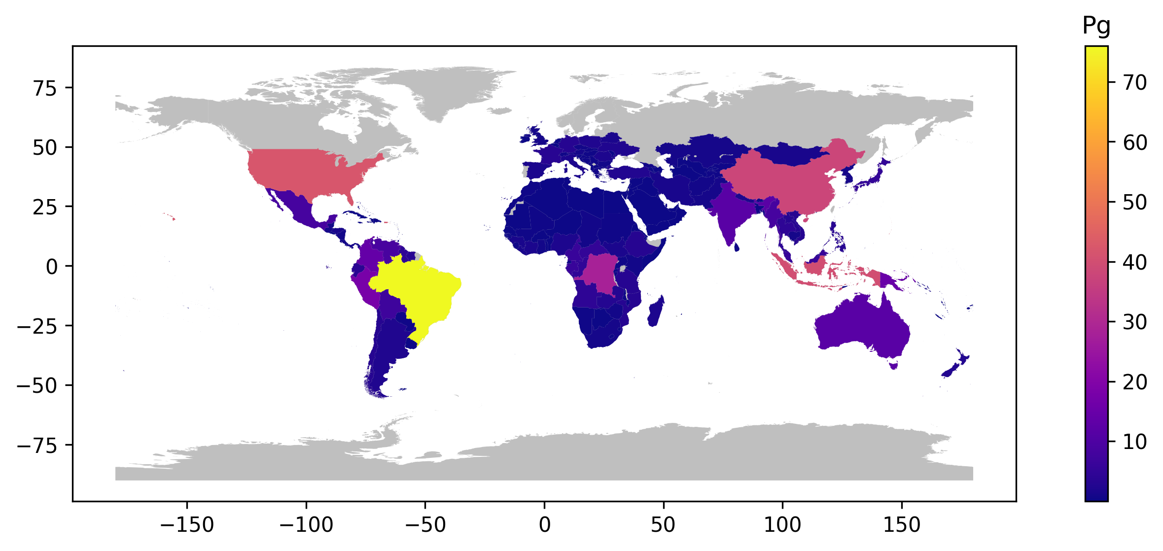
GEDI L4B Country-level Summaries of Aboveground Biomass
National Aeronautics and Space Administration —
This dataset provides country-level estimates of land surface mean aboveground biomass density (AGBD), total aboveground biomass (AGB) stocks, and the associated... -
Federal
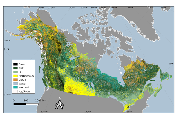
ABoVE: Landsat-derived Annual Dominant Land Cover in Boreal North America, 1986-2020
National Aeronautics and Space Administration —
This dataset contains a 30-m resolution time series of annual land cover classifications as the dominant plant functional type class for all of boreal Alaska and... -
Federal
CMS: LiDAR-derived Canopy Height, Elevation for Sites in Kalimantan, Indonesia, 2014
National Aeronautics and Space Administration —
This dataset provides canopy height and elevation data products derived from airborne LiDAR data collected over 90 sites on the island of Borneo in late 2014. The... -
Federal
ISLSCP II EDGAR 3 Gridded Greenhouse and Ozone Precursor Gas Emissions
National Aeronautics and Space Administration —
The EDGAR (Emission Database for Global Atmospheric Research) database project is a comprehensive task carried out jointly by the National Institute for Public Health... -
Federal
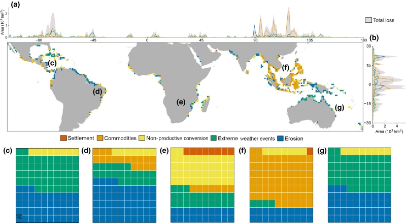
Global Mangrove Loss Extent, Land Cover Change, and Loss Drivers, 2000-2016
National Aeronautics and Space Administration —
This dataset provides estimates of the extent of mangrove loss, land cover change, and its anthropogenic or climatic drivers in three time periods: 2000-2005,... -
Federal
Tidal Wetland Soil Carbon Stocks for the Conterminous United States, 2006-2010
National Aeronautics and Space Administration —
This dataset provides modeled estimates of soil carbon stocks for tidal wetland areas of the Conterminous United States (CONUS) for the period 2006-2010. Wetland... -
Federal
GEDI-FIA Fusion: Training Lidar Models to Estimate Forest Attributes
National Aeronautics and Space Administration —
This dataset includes interpolated cumulative waveforms, with uncertainties, over national forest inventory (FIA) field plots across the contiguous United States. The... -
Federal
Classification of Global Forests for IPCC Aboveground Biomass Tier 1 Estimates, 2020
National Aeronautics and Space Administration —
This dataset provides classes of global forests delineated by status/condition in 2020 at approximately 30-m resolution. The data support generating Tier 1 estimates... -
Federal
NACP Regional: Original Observation Data and Biosphere and Inverse Model Outputs
National Aeronautics and Space Administration —
This data set contains the originally-submitted observation measurement data, terrestrial biosphere model output data, and inverse model simulations that various... -
Federal
Global Soil Profile Data (ISRIC-WISE)
National Aeronautics and Space Administration —
The International Soil Reference and Information Centre-World Inventory of Soil Emission Potentials (ISRIC-WISE) international soil profile data set consists of a...

Official websites use .gov
A
.gov website belongs to an official government
organization in the United States.
Secure .gov websites use HTTPS
A
lock (
) or https:// means you’ve safely connected to
the .gov website. Share sensitive information only on official,
secure websites.