
-
Federal
REGIONAL AIR-SEA INTERACTION (RASI) GAP WIND AND COASTAL UPWELLING EVENTS CLIMATOLOGY GULF OF PANAMA, PANAMA V1
National Aeronautics and Space Administration —
The Regional Air-Sea Interactions (RASI) Gap Wind and Coastal Upwelling Events Climatology Gulf of Panama, Panama dataset was created using an automated intelligent... -
Federal
Geostationary Lightning Mapper (GLM) Thunder Hour Data Product
National Aeronautics and Space Administration —
The Geostationary Lightning Mapper (GLM) is the first optical lightning detector in geostationary orbit, and GLM sensors operate aboard the National Oceanic and... -
Federal
LIS/OTD 2.5 Degree Low Resolution Monthly Climatology Time Series (LRMTS) V2.3.2015
National Aeronautics and Space Administration —
The LIS/OTD 2.5 Degree Low Resolution Monthly Climatology Time Series (LRMTS) contains a variety of gridded climatologies of total lightning flash rates obtained from... -
Federal
World Wide Lightning Location Network (WWLLN) Monthly Thunder Hour Data
National Aeronautics and Space Administration —
The World Wide Lightning Location Network (WWLLN) has monitored global lightning since late 2004. Since 2013, the number of global WWLLN sensors has remained largely... -
Federal
ADVANCED MICROWAVE SOUNDING UNIT-A (AMSU-A) SWATH FROM NOAA-16 V1
National Aeronautics and Space Administration —
AMSU-A, the Advanced Microwave Sounding Unit, is a 15-channel passive microwave radiometer used to profile atmospheric temperature and moisture from the earth's... -
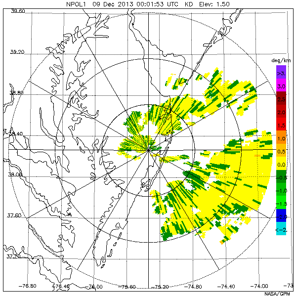
Federal
GPM GROUND VALIDATION NASA S-BAND DUAL POLARIMETRIC (NPOL) DOPPLER RADAR MC3E V1
National Aeronautics and Space Administration —
The GPM Ground Validation NASA S-band Dual Polarimetric (NPOL) Doppler Radar MC3E dataset was collected by the NASA NPOL radar, which was developed by a research team... -
Federal
GPM GROUND VALIDATION DUAL-FREQUENCY DUAL-POLARIZED DOPPLER RADAR (D3R) GCPEX V1
National Aeronautics and Space Administration —
The GPM Ground Validation Dual-frequency Dual-polarized Doppler Radar (D3R) GCPEx and IFloodS data sets contain radar reflectivity and doppler velocity measurements.... -
Federal
GOES-R PLT Airborne Visible/Infrared Imaging Spectrometer (AVIRIS) V1
National Aeronautics and Space Administration —
The GOES-R PLT Airborne Visible/Infrared Imaging Spectrometer (AVIRIS) dataset consists of radiance, reflectance, water phase, and navigation data delivered by the... -
Federal
ADVANCED MICROWAVE SOUNDING UNIT-A (AMSU-A) SWATH FROM NOAA-15 V1
National Aeronautics and Space Administration —
AMSU-A, the Advanced Microwave Sounding Unit, is a 15-channel passive microwave radiometer used to profile atmospheric temperature and moisture from the earth's... -
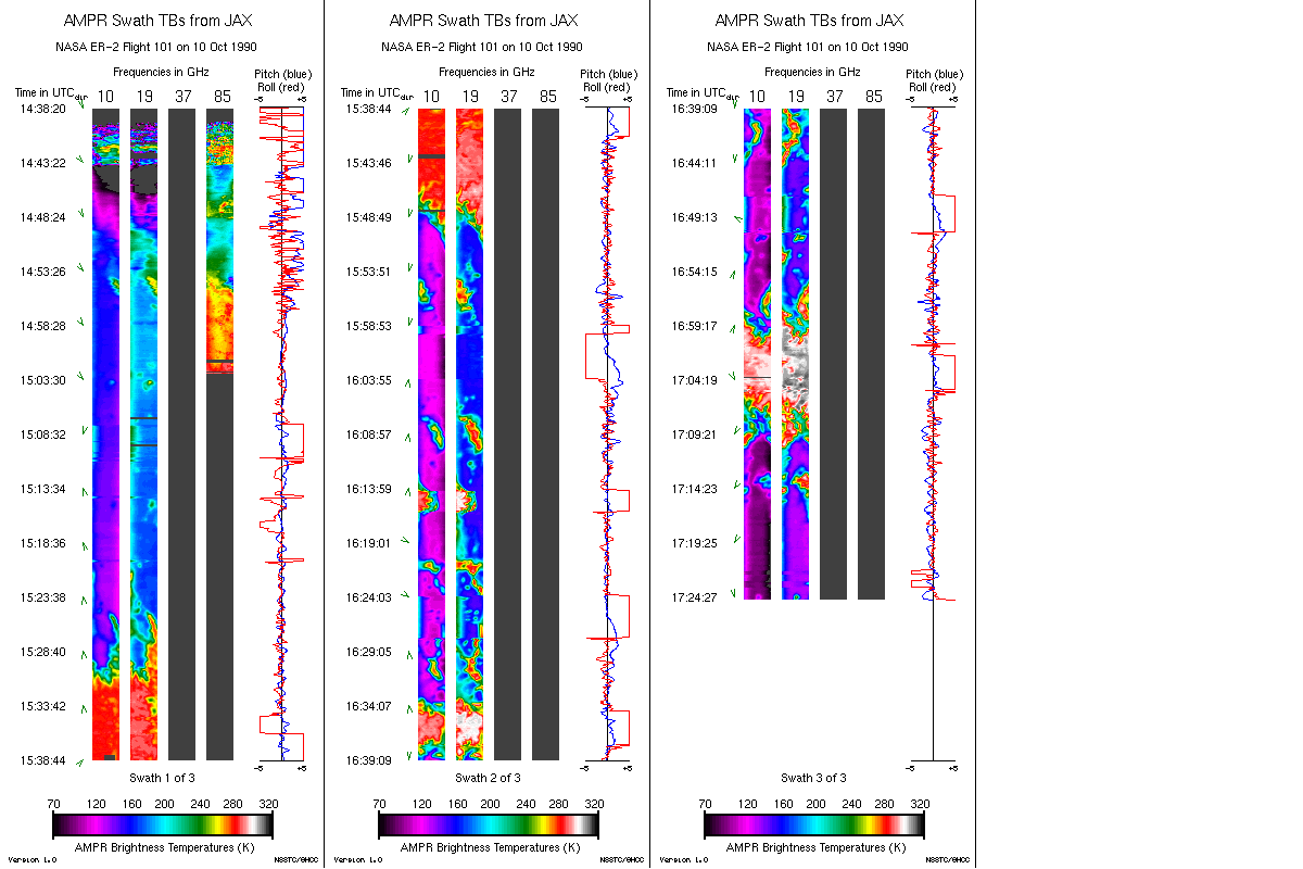
Federal
AMPR JACKSONVILLE BRIGHTNESS TEMPERATURE (TB) V2
National Aeronautics and Space Administration —
The Advanced Microwave Precipitation Radiometer (AMPR) was deployed in Jacksonville, FL for the initial AMPR instrument validation. AMPR data were collected at four... -
Federal
Lightning Imaging Sensor (LIS) on TRMM Science Data V4
National Aeronautics and Space Administration —
The Lightning Imaging Sensor (LIS) Science Data was collected by the LIS instrument on the Tropical Rainfall Measuring Mission (TRMM) satellite used to detect the... -
Federal
LIS/OTD 2.5 Degree Low Resolution Annual Climatology (LRAC) V2.3.2015
National Aeronautics and Space Administration —
The LIS/OTD 2.5 Degree Low Resolution Annual Climatology (LRAC) contains a variety of gridded climatologies of total lightning flash rates obtained from two lightning... -
Federal
TCSP TICOSONDE-AURA 2005 V1
National Aeronautics and Space Administration —
The TCSP TICOSONDE-AURA 2005 dataset consists of 4 soundings per day (00, 06, 12, and 18 UT) launched from Juan Santamaria International Airport, WMO station 78762,... -
Federal
AMSU/MSU Lowtroposphere Day/Month Temperature Anomalies and Annual Cycle V6
National Aeronautics and Space Administration —
The AMSU/MSU Lowtroposphere Day/Month Temperature Anomalies and Annual Cycle V6 dataset consists of temperature anomalies and annual cycle temperatures derived from... -
Federal
CAMEX-4 ER-2 DOPpler radar (EDOP)
National Aeronautics and Space Administration —
The reprocessed ER-2 Doppler Radar(EDOP) data were collected during the fourth field campaign in the Convection And MoistureEXperiment (CAMEX) series, CAMEX-4. This... -
Federal
SBU Mobile Soundings IMPACTS V1
National Aeronautics and Space Administration —
The SBU Mobile Sounding IMPACTS dataset consists of mobile sounding profiles collected during the Investigation of Microphysics and Precipitation for Atlantic Coast-... -
Federal
GPM GROUND VALIDATION OKLAHOMA CLIMATOLOGICAL SURVEY MESONET MC3E V1
National Aeronautics and Space Administration —
The GPM Ground Validation Oklahoma Climatological Survey Mesonet MC3E data were collected during the Midlatitude Continental Convective Clouds Experiment (MC3E) in... -
Federal
CAMEX-3 ER-2 DOPPLER RADAR
National Aeronautics and Space Administration —
The CAMEX-3 ER-2 Doppler Radar dataset was collected by the ER-2 Doppler radar (EDOP), which is an X-band (9.6 GHz) Doppler radar mounted in the nose of ER-2. The... -
Federal
GPM Ground Validation NASA S-Band Dual Polarimetric (NPOL) Doppler Radar Wallops Flight Facility (WFF) V1
National Aeronautics and Space Administration —
The GPM Ground Validation NASA S-Band Dual-Polarimetric (NPOL) Doppler Radar Wallops Flight Facility (WFF) dataset consists of rain rate, reflectivity, Doppler...

Official websites use .gov
A
.gov website belongs to an official government
organization in the United States.
Secure .gov websites use HTTPS
A
lock (
) or https:// means you’ve safely connected to
the .gov website. Share sensitive information only on official,
secure websites.