

13 datasets found for "Water Monitoring"
-
Federal
Groundwater and Soil Moisture Conditions from GRACE and GRACE-FO Data Assimilation L4 7-days 0.125 x 0.125 degree U.S. V4.0 (GRACEDADM_CLSM0125US_7D) at GES DISC
National Aeronautics and Space Administration —
Scientists at NASA Goddard Space Flight Center generate groundwater and soil moisture drought indicators each week. They are based on terrestrial water storage... -
Federal
FLDAS2 Noah-MP GDAS Land Surface Model L4 Central Asia Daily 0.01 degree x 0.01 degree V001 (FLDAS_NOAHMP001_G_CA_D)
National Aeronautics and Space Administration —
This dataset contains land surface parameters simulated by the Famine Early Warning Systems Network (FEWS NET) Land Data Assimilation System version 2 (FLDAS2)... -
Federal
CAR SnowEx17 BRDF Measurements L1 V2 (CAR_SNOWEX17_BRDF) at GES DISC
National Aeronautics and Space Administration —
SnowEx is a multi-year airborne project to help advance capabilities, and plan for a near-future space mission to monitor global seasonal snow water equivalent -... -
Federal
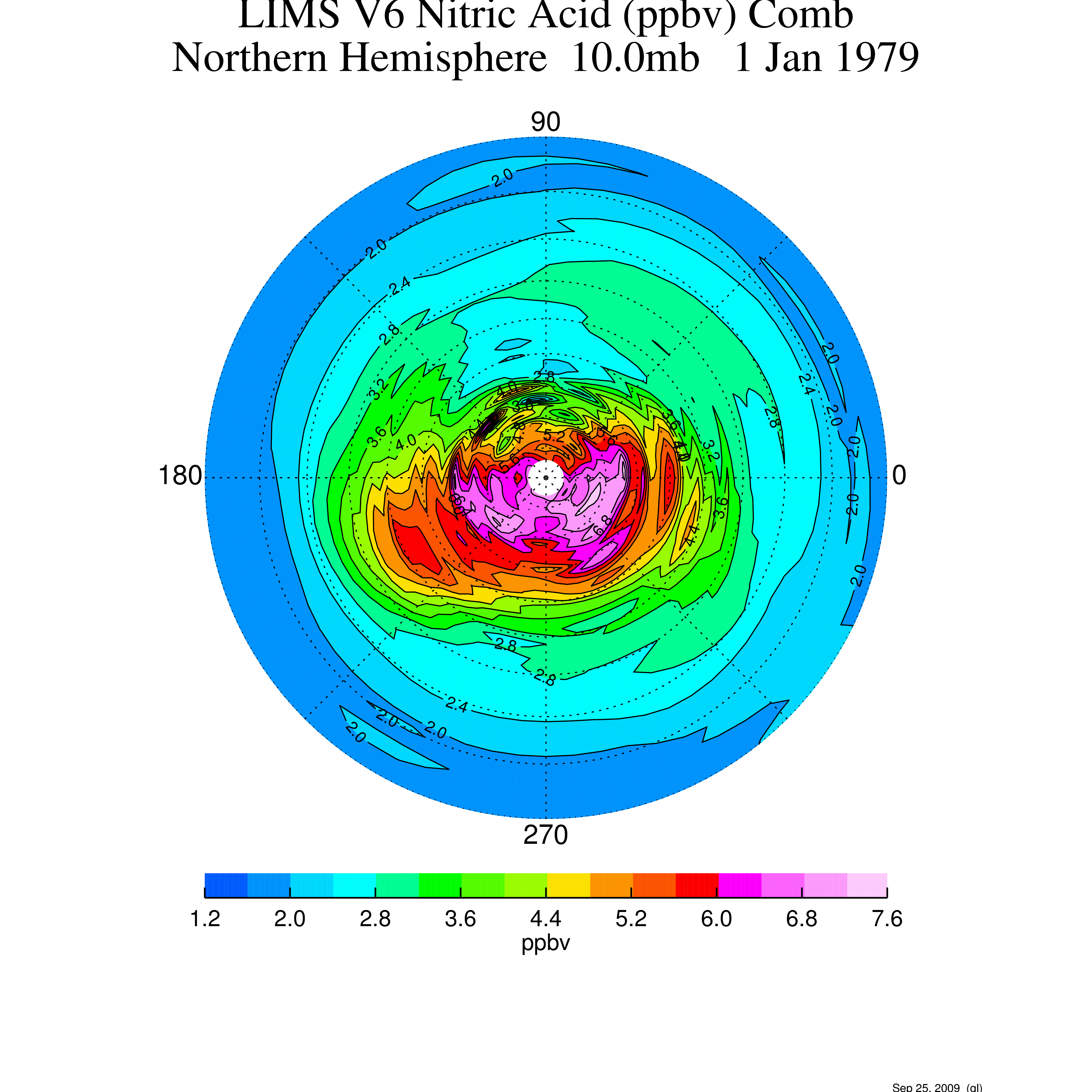
LIMS/Nimbus-7 Level 3 Daily 2 deg Latitude Zonal Fourier Coefficients of O3, NO2, H2O, HNO3, Geopotential Height, and Temperature V006 (LIMSN7L3) at GES DISC
National Aeronautics and Space Administration —
The Limb Infrared Monitor of the Stratosphere (LIMS) version 6 Level-3 data product consists of daily, 2 degree zonal Fourier coefficients, of vertical profiles of... -
Federal
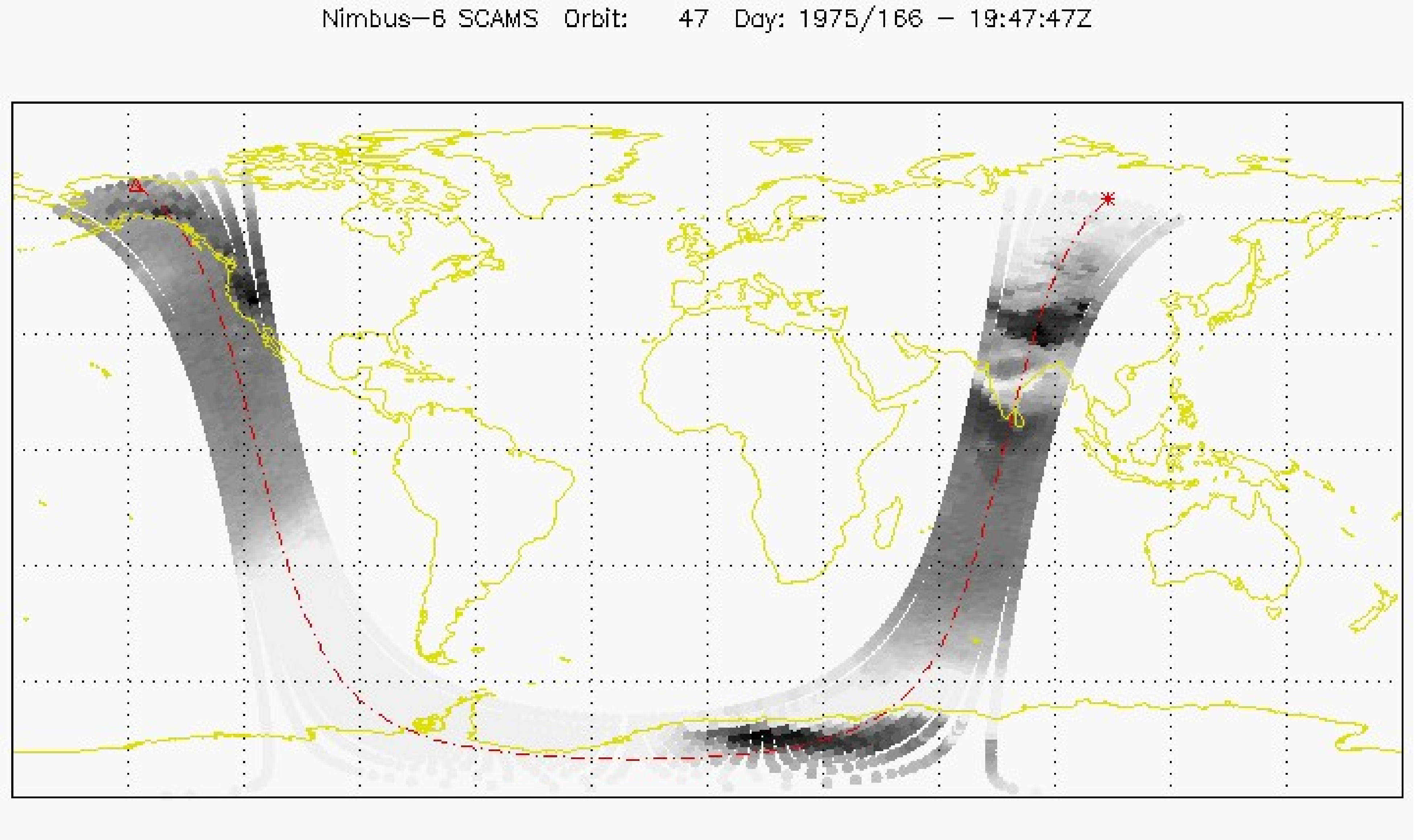
SCAMS/Nimbus-6 Images of Brightness Temperatures, Water Vapor and Temperature on 70-mm Film V001 (SCAMSN6IM) at GES DISC
National Aeronautics and Space Administration —
The SCAMSN6IM data product consists of images of brightness temperatures, water vapor and temperature on 70 mm film strips from the Nimbus-6 Scanning Microwave... -
Federal
LIMS/Nimbus-7 Level 2 Vertical Profiles of O3, NO2, H2O, HNO3, Geopotential Height, and Temperature V006 (LIMSN7L2) at GES DISC
National Aeronautics and Space Administration —
The Limb Infrared Monitor of the Stratosphere (LIMS) version 6 Level-2 data product consists of daily, geolocated, vertical profiles of temperature, geopotential... -
Federal
Groundwater and Soil Moisture Conditions from GRACE and GRACE-FO Data Assimilation L4 7-days 0.25 x 0.25 degree Global V3.0 (GRACEDADM_CLSM025GL_7D) at GES DISC
National Aeronautics and Space Administration —
Scientists at NASA Goddard Space Flight Center generate groundwater and soil moisture drought indicators each week. They are based on terrestrial water storage... -
Federal
Sentinel-5P TROPOMI Methane CH4 1-Orbit L2 5.5km x 7km V2 (S5P_L2__CH4____HiR) at GES DISC
National Aeronautics and Space Administration —
Starting from August 6th in 2019, Sentinel-5P TROPOMI along-track high spatial resolution (~5.5km at nadir) has been implemented.For data before August 6th of 2019,... -
Federal
GPM GMI Brightness Temperatures L1B 1.5 hours 13 km V07 (GPM_1BGMI) at GES DISC
National Aeronautics and Space Administration —
Version 07 is the current version of the data set. Older versions will no longer be available and have been superseded by Version 07.The 1BGMI algorithm uses a non-... -
Federal
Sentinel-5P TROPOMI Methane CH4 1-Orbit L2 7km x 7km V1 (S5P_L2__CH4___) at GES DISC
National Aeronautics and Space Administration —
Starting from August 6th in 2019, Sentinel-5P TROPOMI along-track high spatial resolution (~5.5km at nadir) has been implemented.For data after August 6th of 2019,... -
Federal
SCAMS/Nimbus-6 Level 2 Water Vapor and Temperature, as well as Antenna and Brightness Temperature V001 (SCAMSN6L2) at GES DISC
National Aeronautics and Space Administration —
The Nimbus-6 Scanning Microwave Spectrometer (SCAMS) Level 2 data product contains water vapor and temperature profiles, as well as antenna and brightness... -
Federal
OMI/Aura Hyperspectral UV Irradiance and Underwater Attenuation Coefficient 1-Orbit L2 Swath 13x24km V004 (OMOCNUV) at GES DISC
National Aeronautics and Space Administration —
The Collection 4 Aura Ozone Monitoring Instrument (OMI) Hyperspectral Surface and Underwater UV Irradiances (OMOCNUV) product is now available from the NASA Goddard... -
Federal
CAR SnowEx17 Snow Mass and Energy Measurements L1 V1 (CAR_SNOWEX17_L1C) at GES DISC
National Aeronautics and Space Administration —
SnowEx is a multi-year airborne project to help advance capabilities, and plan for a near-future space mission to monitor global seasonal snow water equivalent —...
13 datasets found for "Water Monitoring"