
-
Federal
GLDAS CLM Land Surface Model L4 3 hourly 1.0 x 1.0 degree Subsetted V001 (GLDAS_CLM10SUBP_3H) at GES DISC
National Aeronautics and Space Administration —
With the upgraded Land Surface Models (LSMs) and updated forcing data sets, the GLDAS version 2.1 (GLDAS-2.1) production stream serves as a replacement for GLDAS-001.... -
Federal
SIRS/Nimbus-3 Level 1 Radiance Data V001 (SIRSN3L1) at GES DISC
National Aeronautics and Space Administration —
SIRSN3L1 is the Nimbus-3 Satellite Infrared Spectrometer (SIRS) Level 1 Radiance Data product. SIRS measured infrared radiation (11 to 36 micrometers) emitted from... -
Federal
GPM MHS on METOP-B (GPROF) Climate-based Radiometer Precipitation Profiling L3 1 day 0.25 degree x 0.25 degree V07 (GPM_3GPROFMETOPBMHS_DAY_CLIM) at GES DISC
National Aeronautics and Space Administration —
Version 07 is the current version of the data set. Older versions are no longer available and have been superseded by Version 07. The "CLIM" products differ from... -
Federal
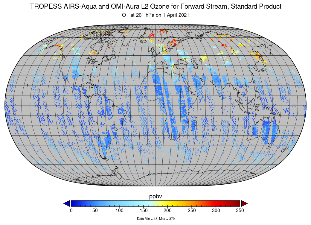
TROPESS AIRS-Aqua and OMI-Aura L2 Ozone for Forward Stream, Standard Product V1 (TRPSDL2O3AIRSOMIFS) at GES DISC
National Aeronautics and Space Administration —
The TROPESS AIRS-Aqua and OMI-Aura L2 Ozone for Forward Stream, Standard Product contains the vertical distribution of the retrieved atmospheric state of ozone (O3),... -
Federal
CAR CLAMS BRDF Measurements V2 (CAR_CLAMS_BRDF) at GES DISC
National Aeronautics and Space Administration —
CLAMS is the Chesapeake Lighthouse and Aircraft Measurements for Satellites field campaign sponsored by CERES, MISR, MODIS-Atmospheres and the NASA/GEWEX Global... -
Federal
SeaWiFS Deep Blue Aerosol Optical Depth and Angstrom Exponent Daily Level 3 Data Gridded at 0.5 Degrees V004 (SWDB_L305) at GES DISC
National Aeronautics and Space Administration —
The SeaWiFS Deep Blue (SWDB) Level 3 daily global gridded (0.5 x 0.5 deg) data is derived from SeaWiFS Deep Blue Level 2 data. In most cases, each data field... -
Federal
TOMS Earth Probe UV Aerosol Index Monthly L3 Global 1 deg x 1.25 deg Lat/Lon Grid V008 (TOMSEPL3maer) at GES DISC
National Aeronautics and Space Administration —
This Earth Probe (EP) Total Ozone Mapping Spectrometer (TOMS) version 8 monthly averaged global gridded data product contains UV aerosol index values. The data are... -
Federal
MERRA-2 tavgU_3d_tdt_Np: 3d,diurnal,Time-Averaged,Pressure-Level,Assimilation,Temperature Tendencies 0.625 x 0.5 degree V5.12.4 (M2TUNPTDT) at GES DISC
National Aeronautics and Space Administration —
M2TUNPTDT (or tavgU_3d_tdt_Np) is a 3-dimensional monthly diurnal means data collection in Modern-Era Retrospective analysis for Research and Applications version 2... -
Federal
TROPESS CrIS-SNPP L2 Methane for Australian Fires, Standard Product V1 (TRPSDL2CH4CRSAUS) at GES DISC
National Aeronautics and Space Administration —
The TROPESS CrIS-SNPP L2 Methane for Australian Fires, Standard Product contains the vertical distribution of the retrieved atmospheric state of methane (CH4), formal... -
Federal
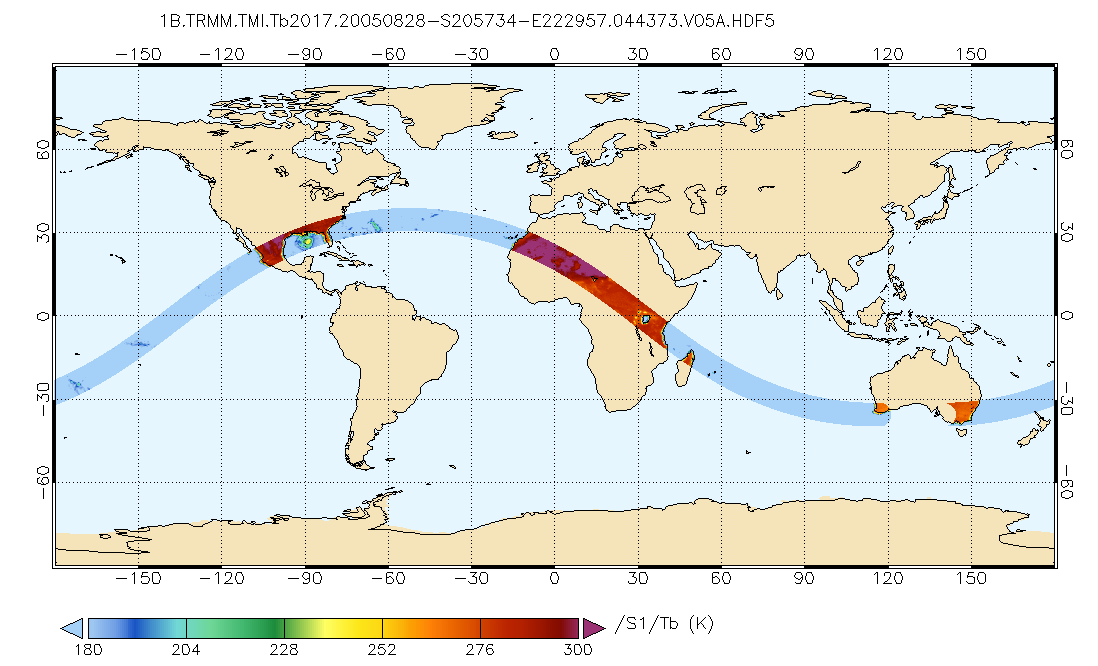
GPM TMI on TRMM Brightness Temperatures L1B 1.5 hours 13 km V07 (GPM_1BTMI) at GES DISC
National Aeronautics and Space Administration —
This is the new (GPM-formated) TRMM product. It replaces the old TRMM_1B11 Version 07 is the current version of the data set. Previous versions have been superseded... -
Federal
MERRA-2 tavgU_2d_csp_Nx: 2d,diurnal,Time-averaged,Single-Level,Assimilation,COSP Satellite Simulator 0.625 x 0.5 degree V5.12.4 (M2TUNXCSP) at GES DISC
National Aeronautics and Space Administration —
M2TUNXCSP (or tavgU_2d_csp_Nx) is a time-averaged 2-dimensional monthly diurnal means data collection in Modern-Era Retrospective analysis for Research and... -
Federal
VISSR/GOES-1 Infrared Imagery on 70mm Film V001 (VISSRGOES1IMIR) at GES DISC
National Aeronautics and Space Administration —
VISSRGOES1IMIR is the Visible Infrared Spin-Scan Radiometer (VISSR) Infrared Imagery on 70mm Film data product from the first Geostationary Operational Environmental... -
Federal
VISSR/GOES-3 Infrared Imagery on 70mm Film V001 (VISSRGOES3IMIR) at GES DISC
National Aeronautics and Space Administration —
VISSRGOES3IMIR is the Visible Infrared Spin-Scan Radiometer (VISSR) Infrared Imagery on 70mm Film data product from the third Geostationary Operational Environmental... -
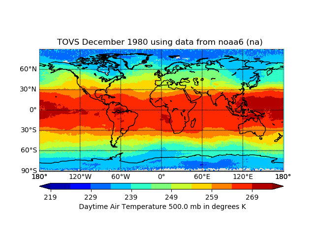
Federal
TOVS GLA MONTHLY GRIDS from NOAA-6 02 (TOVSAMNA) at GES DISC
National Aeronautics and Space Administration —
This dataset (TOVSAMNA) contains the TIROS Operational Vertical Sounder (TOVS) level 3 geophysical parameters derived using data from NOAA-6 and the physical... -
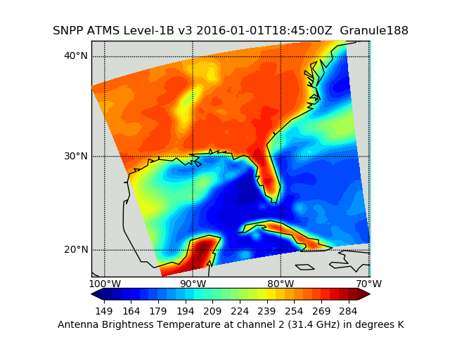
Federal
Suomi NPP ATMS Sounder Science Investigator-led Processing System (SIPS) Level 1B Brightness Temperature V3 (SNPPATMSL1B) at GES DISC
National Aeronautics and Space Administration —
The Advanced Technology Microwave Sounder (ATMS) Level 1B data files contain brightness temperature measurements along with ancillary spacecraft, instrument, and... -
Federal
TROPESS Chemical Reanalysis Surface Total CO emissions Monthly 2-dimensional Product V1 (TRPSCRECOTM2D) at GES DISC
National Aeronautics and Space Administration —
The TROPESS Chemical Reanalysis Surface Total CO emissions Monthly 2-dimensional Product contains carbon monoxide emissions from the total of all sources. The data... -
Federal
CAR Safari South African Biogeophysics and Biogeochemistry L1 V1 (CAR_SAFARI_L1C) at GES DISC
National Aeronautics and Space Administration —
The Southern African Regional Science Initiative (SAFARI) 2000 is an international science field campaign aimed at developing a better understanding of the southern... -
Federal
Carbon Monitoring System Carbon Flux Ocean L4 V3 (CMSFluxOcean)
National Aeronautics and Space Administration —
This dataset provides the Posterior Carbon Flux for the Ocean.The NASA Carbon Monitoring System (CMS) is designed to make significant contributions in characterizing,... -
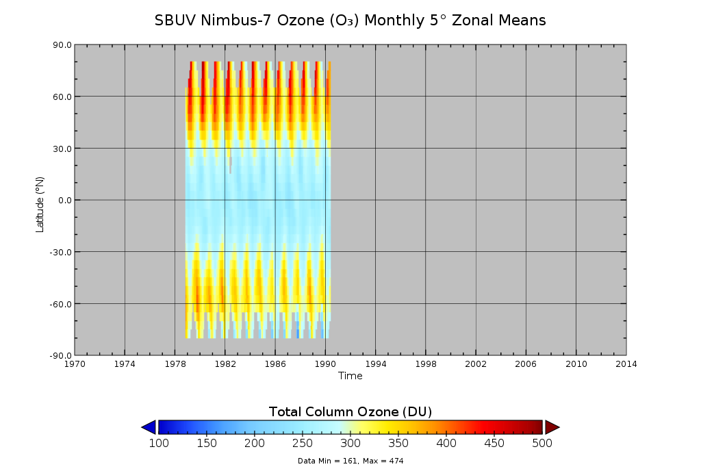
Federal
SBUV/Nimbus-7 Ozone (O3) Profile and Total Column Ozone 1 Month Zonal Mean L3 Global 5.0 degree Latitude Zones V1 (SBUVN07L3zm) at GES DISC
National Aeronautics and Space Administration —
The Solar Backscattered Ultraviolet (SBUV) from Nimbus-7 Level-3 monthly zonal mean (MZM) product (SBUVN07L3zm) is derived from the Level-2 retrieved ozone profiles.... -
Federal
Sounder SIPS: AQUA AIRS IR + MW Level 2: Atmospheric state at Standard Pressure Levels derived from CLIMCAPS V2.1 (SNDRAQIML2PLEVCPS) at GES DISC
National Aeronautics and Space Administration —
The CLIMCAPS (Community Long-term Infrared Microwave Coupled Product System) algorithm is used to analyze data from the AIRS (Atmospheric Infrared Sounder)/AMSU...

Official websites use .gov
A
.gov website belongs to an official government
organization in the United States.
Secure .gov websites use HTTPS
A
lock (
) or https:// means you’ve safely connected to
the .gov website. Share sensitive information only on official,
secure websites.