

11 datasets found for "四方娱乐棋牌源码/金币房卡双模式/52个子游戏/亲友圈/原生双端APP/带控制✅项目合作 二开均可 TG:saolei44✅.SGxrLwzoXmoSYLq"
-
Federal
GLDAS CLM Land Surface Model L4 3 hourly 1.0 x 1.0 degree Subsetted V001 (GLDAS_CLM10SUBP_3H) at GES DISC
National Aeronautics and Space Administration —
With the upgraded Land Surface Models (LSMs) and updated forcing data sets, the GLDAS version 2.1 (GLDAS-2.1) production stream serves as a replacement for GLDAS-001.... -
Federal
TROPESS Chemical Reanalysis Surface OH 2-Hourly 2-dimensional Product V1 (TRPSCROH2H2D) at GES DISC
National Aeronautics and Space Administration —
The TROPESS Chemical Reanalysis OH 2-Hourly 2-dimensional Product contains surface concentrations of the hydroxyl radical. The data are part of the Tropospheric... -
Federal
GLDAS VIC Land Surface Model L4 monthly 1.0 x 1.0 degree V2.1 (GLDAS_VIC10_M) at GES DISC
National Aeronautics and Space Administration —
NASA Global Land Data Assimilation System Version 2 (GLDAS-2) has three components: GLDAS-2.0, GLDAS-2.1, and GLDAS-2.2. GLDAS-2.0 is forced entirely with the... -
Federal
MLS/Aura Level 3 Daily Binned Water Vapor (H2O) Mixing Ratio on Zonal and Similar Grids V004 (ML3DZH2O) at GES DISC
National Aeronautics and Space Administration —
ML3DZH2O is the EOS Aura Microwave Limb Sounder (MLS) daily binned on zonal and assorted vertical grids product for water vapor (H2O) derived from radiances measured... -
Federal
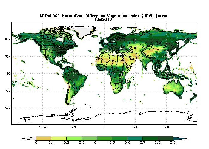
MODIS/Aqua Monthly Vegetation Indices Global 1x1 degree V005 (MYDVI) at GES DISC
National Aeronautics and Space Administration —
The global monthly gridded MODIS vegetation indices product is derived from the standard 0.05 CMG MODIS Aqua Vegetation Indices Monthly product MYD13C2 (Huete et al,... -
Federal
MLS/Aura Level 3 Monthly Binned Relative Humidity With Respect To Ice (RHI) on Assorted Grids V004 (ML3MBRHI) at GES DISC
National Aeronautics and Space Administration —
ML3MBRHI is the EOS Aura Microwave Limb Sounder (MLS) monthly binned on various vertical grids product for relative humidity with respect to ice (RHI) derived from... -
Federal
Sentinel-5P TROPOMI Radiance product band 7 (SWIR detector) L1B 5.5km x 7km V1 (S5P_L1B_RA_BD7_HiR) at GES DISC
National Aeronautics and Space Administration —
Starting from August 6th in 2019, Sentinel-5P TROPOMI along-track high spatial resolution (~5.5km at nadir) has been implemented.For data before August 6th of 2019,... -
Federal
MERRA-2 tavgU_2d_flx_Nx: 2d,diurnal,Time-Averaged,Single-Level,Assimilation,Surface Flux Diagnostics 0.625 x 0.5 degree V5.12.4 (M2TUNXFLX) at GES DISC
National Aeronautics and Space Administration —
M2TUNXFLX (or tavgU_2d_flx_Nx) is a time-averaged 2-dimensional monthly diurnal means data collection in Modern-Era Retrospective analysis for Research and... -
Federal
WLDAS Noah-MP 3.6 Land Surface Model L4 Daily 0.01 degree x 0.01 degree Version D1.0 (WLDAS_NOAHMP001_DA1) at GES DISC
National Aeronautics and Space Administration —
The Western Land Data Assimilation System (WLDAS), developed at Goddard Space Flight Center (GSFC) and funded by the NASA Western Water Applications Office, provides... -
Federal
FLDAS Noah Land Surface Model L4 Global Monthly Climatology 0.1 x 0.1 degree (MERRA-2 and CHIRPS) V001 (FLDAS_NOAH01_C_GL_MC) at GES DISC
National Aeronautics and Space Administration —
The monthly climatology dataset contains a series of land surface parameters simulated from the Noah 3.6.1 model in the Famine Early Warning Systems Network (FEWS... -
Federal
Aqua/AIRS L2 Cloud-Cleared Infrared Radiances (AIRS+AMSU) V7.0 at GES DISC
National Aeronautics and Space Administration —
The Atmospheric Infrared Sounder (AIRS) is a grating spectrometer (R = 1200) aboard the second Earth Observing System (EOS) polar-orbiting platform, EOS Aqua. In...
11 datasets found for "四方娱乐棋牌源码/金币房卡双模式/52个子游戏/亲友圈/原生双端APP/带控制✅项目合作 二开均可 TG:saolei44✅.SGxrLwzoXmoSYLq"