
-
Federal
Vegetation Species Reference (FIFE)
National Aeronautics and Space Administration —
The Konza Natural Research Area is a tallgrass prairie in a biologically heterogeneous environment that is rich in native plant species. Species composition is... -
Federal
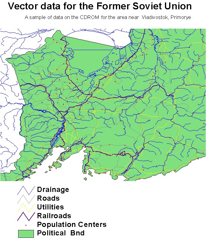
RLC Selected Infrastructure Data for the Former Soviet Union, 1993
National Aeronautics and Space Administration —
This data set consists of roads, drainage, railroads, utilities, and population center information in readily usable vector format for the land area of the Former... -
Federal
RLC Forest Stand Carbon Map of Russia
National Aeronautics and Space Administration —
This dataset is a 1:15 million scale map of forest stand carbon for the land area of Russia (Stone et al., 2000). The objective was to create a first approximation of... -
Federal
RLC Forest Cover of the Former Soviet Union, 1973
National Aeronautics and Space Administration —
This data set is a 1:15 million scale forest cover map for the land area of the Former Soviet Union. Twenty-two land cover classes are distinguished, of which 20 are... -
Federal
SAFARI 2000 Carbon in Live Vegetation, 0.5-Deg (Olson)
National Aeronautics and Space Administration —
This data set is a subset of Olson's Major World Ecosystem Complexes for southern Africa in ASCII GRID and binary image files formats. Olson's Major World Ecosystem... -
Federal
VISSR/SMS-2 Infrared Imagery on 70mm Film V001 (VISSRSMS2IMIR) at GES DISC
National Aeronautics and Space Administration —
VISSRSMS2IMIR is the Visible Infrared Spin-Scan Radiometer (VISSR) Infrared Imagery on 70mm Film data product from the second Synchronous Meteorological Satellite... -
Federal
Walker Branch Watershed Vegetation Inventory, 1967-2006, R1
National Aeronautics and Space Administration —
This data set contains five data files, in comma-separated format (.csv), derived from the Walker Branch Watershed (WBW) vegetation inventory in eastern Tennessee.... -
Federal
VISSR/GOES-3 Visible Imagery on 70mm Film V001 (VISSRGOES3IMVIS) at GES DISC
National Aeronautics and Space Administration —
VISSRGOES3IMVIS is the Visible Infrared Spin-Scan Radiometer (VISSR) Visible Imagery on 70mm Film data product from the third Geostationary Operational Environmental... -
Federal
TransCom 3: Seasonal CO2 Flux Estimates from Atmospheric Inversions (Level 2)
National Aeronautics and Space Administration —
This data set provides model outputs and seasonal mean CO2 fluxes from the Atmospheric Carbon Cycle Inversion Intercomparison (TransCom 3), Level 2 inversion... -
Federal
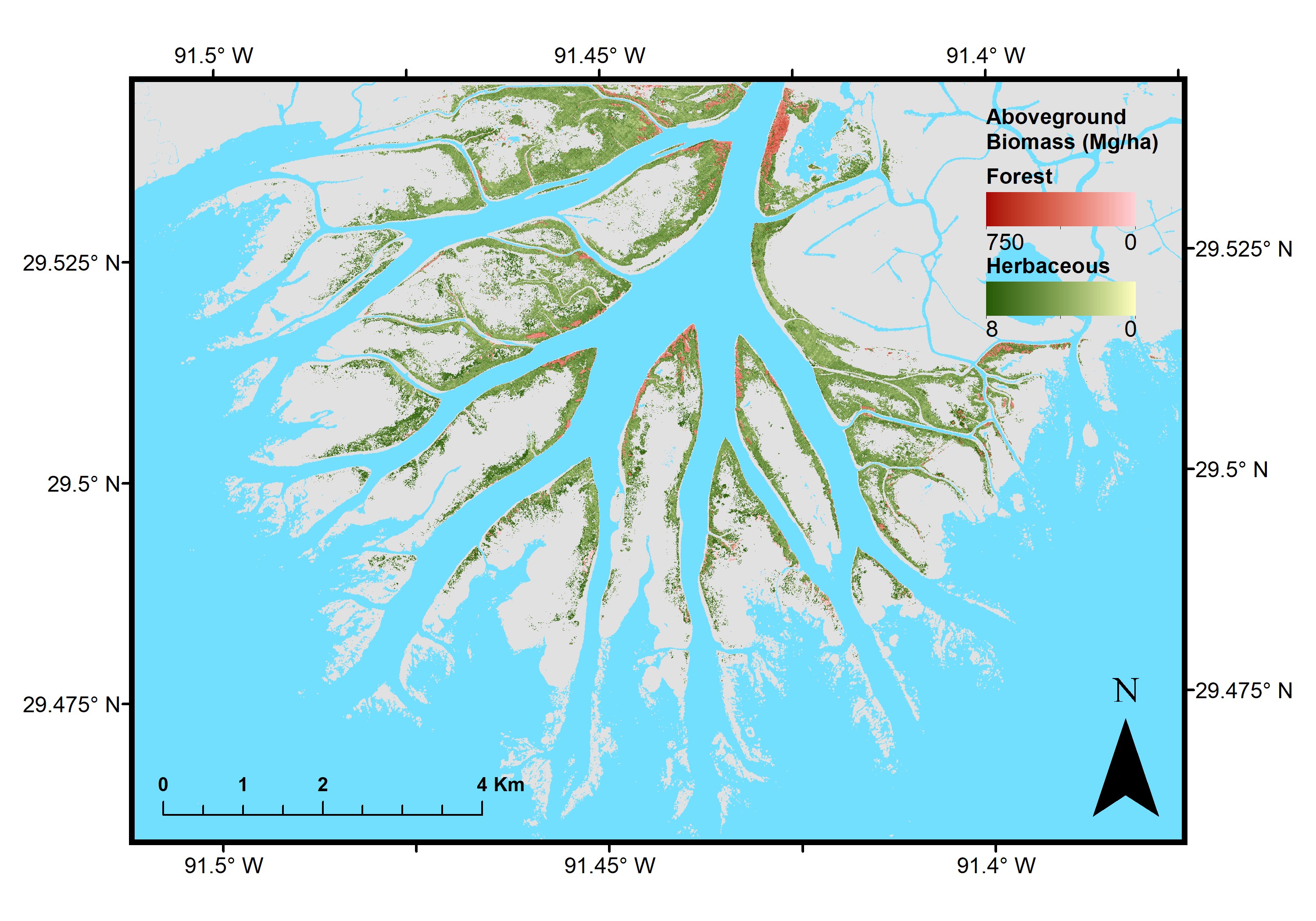
Pre-Delta-X: Aboveground Biomass and Vegetation Maps, Wax Lake Delta, LA, USA, 2016
National Aeronautics and Space Administration —
This dataset includes aboveground biomass (AGB) and vegetation of herbaceous and forest wetland at 5.4 m resolution across the Wax Lake Delta (WLD) in Southern... -
Federal
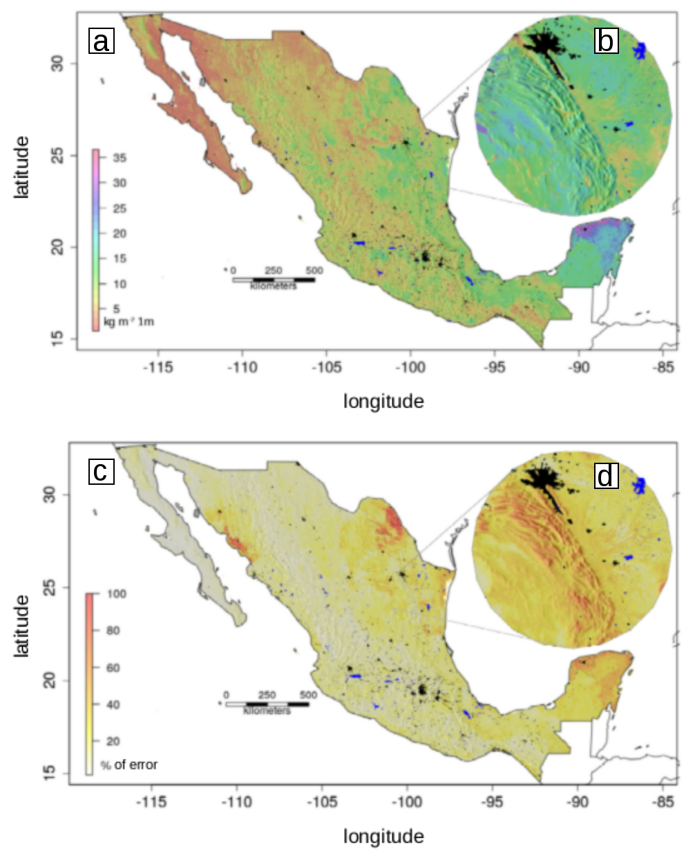
Soil Organic Carbon Estimates and Uncertainty at 1-m Depth across Mexico, 1999-2009
National Aeronautics and Space Administration —
This dataset provides an estimate of soil organic carbon (SOC) in the top one meter of soil across Mexico at a 90-m resolution for the period 1999-2009. Carbon... -
Federal
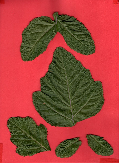
SHIFT: Photosynthetic and Leaf Traits, Santa Barbara County, 2022
National Aeronautics and Space Administration —
This dataset provides leaf images and measurements of leaf traits (area, wet weight, dry weight, leaf mass per area, leaf water content) and leaf pigments... -
Federal
Global Food Security-support Analysis Data (GFSAD) Cropland Extent 2010 North America product 30 m V001
National Aeronautics and Space Administration —
The NASA Making Earth System Data Records for Use in Research Environments (MEaSUREs) Global Food Security-support Analysis Data (GFSAD) data product provides... -
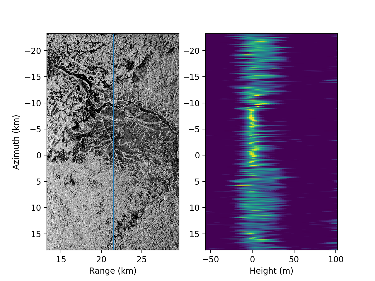
Federal
AfriSAR: Polarimetric Height Profiles by TomoSAR, Lope and Rabi Forests, Gabon, 2016
National Aeronautics and Space Administration —
This dataset provides height profiles derived from UAVSAR (Uninhabited Aerial Vehicle Synthetic Aperture Radar; JPL) data acquired over Lope National Park and Rabi... -
Federal
AfriSAR: Aboveground Biomass for Lope, Mabounie, Mondah, and Rabi Sites, Gabon
National Aeronautics and Space Administration —
This dataset provides gridded estimates of aboveground biomass (AGB) for four sites in Gabon at 0.25 ha (50 m) resolution derived with field measurements and airborne... -
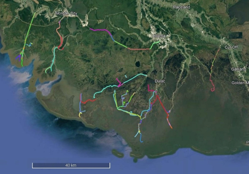
Federal
Delta-X: Sonar Bathymetry Survey of Channels, MRD, Louisiana, 2021
National Aeronautics and Space Administration —
This dataset includes bathymetry data for water channels in a portion of the Mississippi River Delta (MRD) of coastal Louisiana. The data were collected using sonar... -
Federal
CER_BDS_Terra-FM2_Edition4
National Aeronautics and Space Administration —
CER_BDS_Terra-FM2_Edition4 is the Clouds and the Earth's Radiant Energy System (CERES) Bidirectional Scans (BDS) Terra Flight Model 2 (FM2) Edition 4 data product,... -
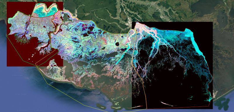
Federal
Delta-X: Ecogeomorphic Cell Products across the MRD, LA, USA, 2021
National Aeronautics and Space Administration —
This product delineates the Mississippi River Delta (MRD) landscape into distinct ecogeomorphic cells, which are small contiguous areas of land with similar... -
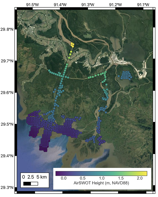
Federal
Delta-X: AirSWOT L3 Water Surface Elevations, MRD, Louisiana, 2021, Version 2
National Aeronautics and Space Administration —
This dataset contains water surface elevations at selected point locations generated from the AirSWOT data collected during the Spring and Fall 2021 Delta-X... -
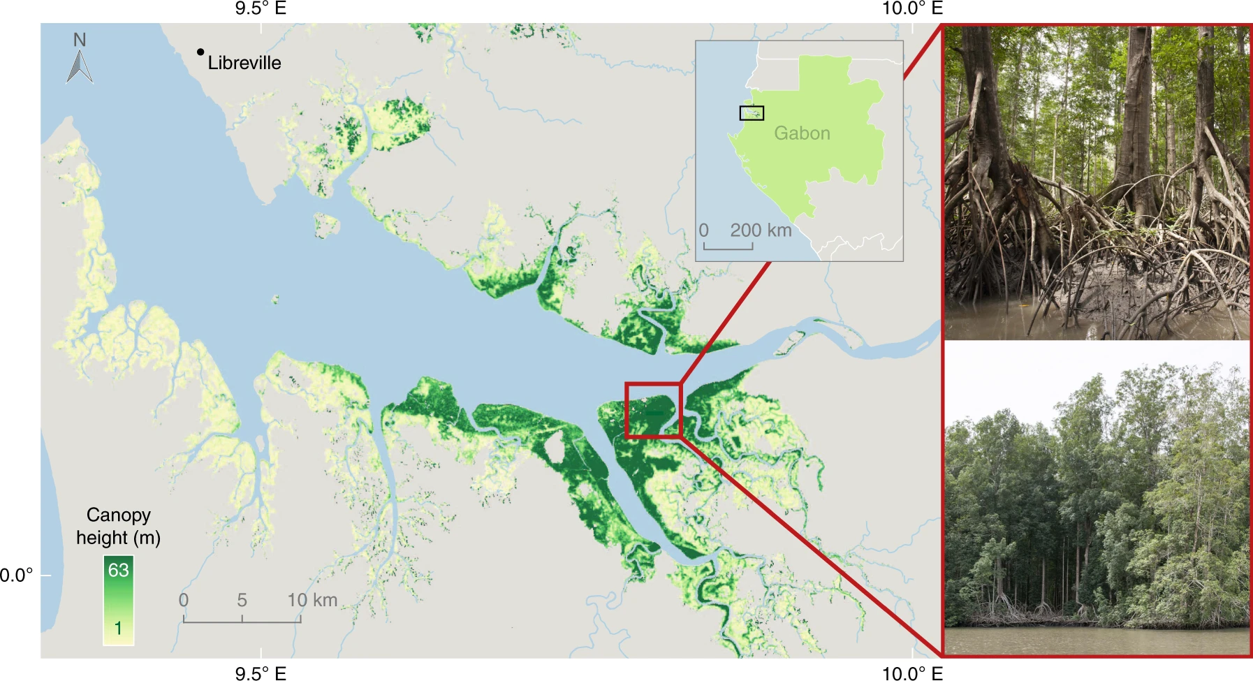
Federal
CMS: Global Mangrove Canopy Height Maps Derived from TanDEM-X, 2015
National Aeronautics and Space Administration —
This dataset characterizes canopy heights of mangrove-forested wetlands globally for 2015 at 12-m resolution. Estimates of maximum canopy height (height of the...

Official websites use .gov
A
.gov website belongs to an official government
organization in the United States.
Secure .gov websites use HTTPS
A
lock (
) or https:// means you’ve safely connected to
the .gov website. Share sensitive information only on official,
secure websites.