
-
Federal
VIIRS/NPP Surface Reflectance Daily L2G Global 1km and 500m SIN Grid V002
National Aeronautics and Space Administration —
The Visible Infrared Imaging Radiometer Suite (VIIRS) daily surface reflectance (VNP09GA) Version 2 product provides an estimate of land surface reflectance from the... -
Federal
Sounder SIPS: Suomi NPP CrIMSS Level 2 CLIMCAPS Normal Spectral Resolution: Atmospheric state at Standard Pressure Levels derived from CLIMCAPS V2.1 (SNDRSNIML2PLEVCPSN) at GES DISC
National Aeronautics and Space Administration —
The CLIMCAPS (Community Long-term Infrared Microwave Coupled Product System) algorithm is used to analyze data from the Cross-track Infrared Sounder/Advanced... -
Federal
SMEX02 Iowa Regional Ground Soil Moisture Data, Version 1
National Aeronautics and Space Administration —
These data were collected as part of a validation study for the Advanced Microwave Scanning Radiometer - Earth Observing System (AMSR-E). Data were collected in crop... -
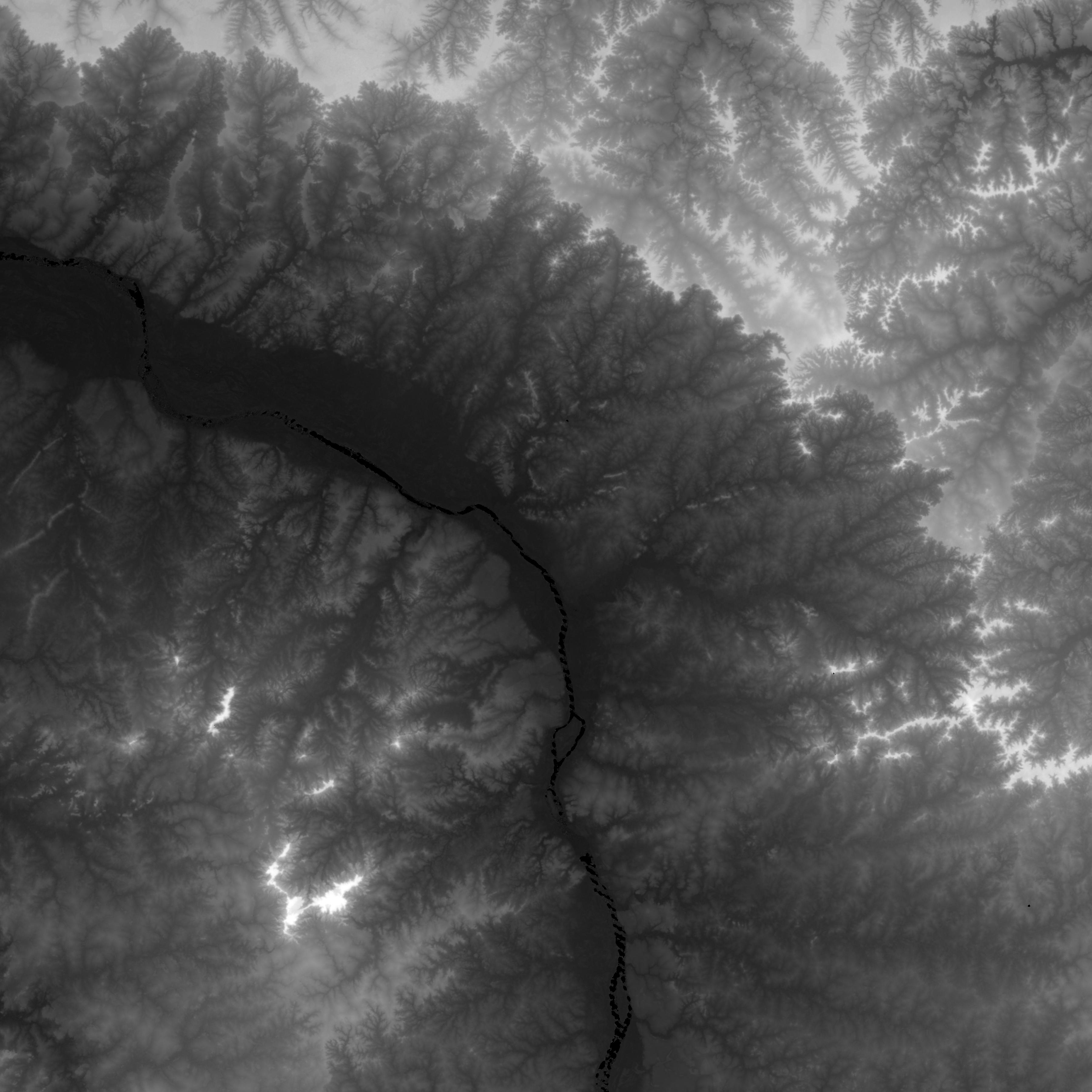
Federal
NASADEM SRTM-only Height and Height Precision Mosaic Global 1 arc second V001
National Aeronautics and Space Administration —
The Land Processes Distributed Active Archive Center (LP DAAC) is responsible for the archive and distribution of NASA Making Earth System Data Records for Use in... -
Federal
Global Food Security-support Analysis Data (GFSAD) Cropland Extent 2015 Australia, New Zealand, China, Mongolia 30 m V001
National Aeronautics and Space Administration —
The NASA Making Earth System Data Records for Use in Research Environments (MEaSUREs) Global Food Security-support Analysis Data (GFSAD) data product provides... -
Federal
GHRSST NOAA/STAR GOES-17 ABI L2P America Region SST v2.71 dataset in GDS2
National Aeronautics and Space Administration —
GOES-17 (G17) is the second satellite in the US NOAA's GOES-R series. It was launched on 1 Mar 2018 in an interim position at 89.5-deg W for initial Cal/Val, moved to... -
Federal
Spitzer Deep Wide-Field Survey Light Curve Catalog
National Aeronautics and Space Administration —
The Spitzer Deep, Wide-Field Survey (SDWFS) is a four-epoch infrared survey of 10 square degrees in the Boötes field of the NOAO Deep Wide-Field Survey using the IRAC... -
Federal
BARREL 1D Tri-axial Fluxgate Magnetometer (MAGN) Magnetic Field Data, no Gain Correction, not Despun, Level 2, 0.25 s Data
National Aeronautics and Space Administration —
Three axis DC magnetometer data with nominal conversions applied. Data are neither gain corrected nor despun.The BARREL Mission was a multiple-balloon investigation... -
Federal
BARREL 2W Ephemeris (EPHM) Geographic and Magnetic Coordinates, Level 2, 4 s Data
National Aeronautics and Space Administration —
Geographic and Magnetic Coordinates: The ephemeris data products, which include the balloon epoch time, latitude, longitude, and altitude, are each returned from the... -
Federal
BARREL 4B X-ray Spectrometer (FSPC) Bremsstrahlung X-ray Spectrum Fast Time Resolution, Level 2, 0.05 s Data
National Aeronautics and Space Administration —
FSPC: Six channels of fast time resolution, 50 ms, Bremsstrahlung X-ray spectra detected with a NaI Scintillator. Each channel is separated in its own variable:... -
Federal
2XMMi/SDSS Galaxy Cluster Survey
National Aeronautics and Space Administration —
The authors have compiled a sample of X-ray-selected galaxy groups and clusters from the XMM-Newton Serendipitous Source Catalog (2XMMi-DR3) with optical confirmation... -
Federal
Ground-Based Global Navigation Satellite System (GNSS) Satellite-Based Augmentation System (SBAS) Broadcast Ephemeris Data (sub-hourly files) from NASA CDDIS
National Aeronautics and Space Administration —
This dataset consists of ground-based Global Navigation Satellite System (GNSS) Satellite-Based Augmentation System (SBAS) Broadcast Ephemeris Data (sub-hourly files)... -
Federal
MMS 4 Magnetic Ephemeris and Coordinates (MEC) and Support (Tsyganenko 2004 model, Dynamic conditions), Level 2 (L2), Survey Mode, 30 s Data
National Aeronautics and Space Administration —
Magnetospheric Multiscale 4 (MMS 4) spacecraft position, velocity, attitude, angular momentum vector, and magnetic ephemeris and coordinates (MEC), Level-2 science... -
Federal
MMS 3 Fast Plasma Investigation, Dual Electron Spectrometer (FPI, DES) Partial Distribution Moments, Level 2 (L2), Fast Mode, 4.5 s Data
National Aeronautics and Space Administration —
FPI usually operates in Fast Survey (FS) Mode in the MMS Region Of Interest (ROI) for the current Mission Phase. Data are taken at Burst (30/150 ms for DES/DIS)... -
Federal
Pre-ABoVE: Active Layer Thickness and Soil Water Content, Barrow, Alaska, 2013
National Aeronautics and Space Administration —
This data set provides estimates of Active Layer Thickness (ALT) determined with ground-based measurements, and calculated soil volumetric water content (VWC) at four... -
Federal
Developing IVHM Requirements for Aerospace Systems
National Aeronautics and Space Administration —
The term Integrated Vehicle Health Management (IVHM) describes a set of capabilities that enable sustainable and safe operation of components and subsystems within... -
Federal
MMS 4 Fast Plasma Investigation, Dual Ion Spectrometer (FPI, DIS) Partial Distribution Moments, Level 2 (L2), Burst Mode, 0.15 s Data
National Aeronautics and Space Administration —
FPI usually operates in Fast Survey (FS) Mode in the MMS Region Of Interest (ROI) for the current Mission Phase. Data are taken at Burst (30/150 ms for DES/DIS)... -
Federal
THEMIS-D: On Board moments: ESA and SST Electron/Ion moments, density, flux, velocity, pressure and temperature.
National Aeronautics and Space Administration —
THEMIS-D On Board moments. On board data outputs include number density, particle flux, energy flux, and a six component symetric momentum flux tensor. Other moments... -
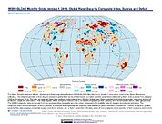
Federal
Water Security Indicator Model - Global Land Data Assimilation System (WSIM-GLDAS) Monthly Grids, Version 1
National Aeronautics and Space Administration —
The Water Security Indicator Model - Global Land Data Assimilation System (WSIM-GLDAS) Monthly Grids, Version 1 data set identifies and characterizes surpluses and... -
Federal
Global Food Security-support Analysis Data (GFSAD) Cropland Extent 2015 Europe, Central Asia, Russia, Middle East product 30 m V001
National Aeronautics and Space Administration —
The NASA Making Earth System Data Records for Use in Research Environments (MEaSUREs) Global Food Security-support Analysis Data (GFSAD) data product provides...

Official websites use .gov
A
.gov website belongs to an official government
organization in the United States.
Secure .gov websites use HTTPS
A
lock (
) or https:// means you’ve safely connected to
the .gov website. Share sensitive information only on official,
secure websites.