
-
Federal
IRIS/Nimbus-4 Level 1 Radiance Data V001 (IRISN4RAD) at GES DISC
National Aeronautics and Space Administration —
The Nimbus-4 Infrared Interferometer Spectrometer (IRIS) Level 1 Radiance Data contain thermal emissions of the Earth's atmosphere at wave numbers between 400 and... -
Federal
CYGNSS Level 2 Ocean Surface Heat Flux Science Data Record Version 1.0
National Aeronautics and Space Administration —
This dataset contains the Version 1.0 CYGNSS Level 2 Ocean Surface Heat Flux Science Data Record, which provides the time-tagged and geolocated ocean surface heat... -
Federal
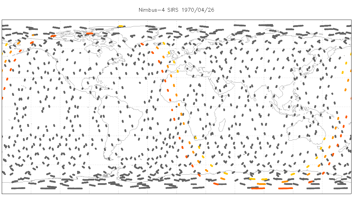
SIRS/Nimbus-4 Level 1 Radiance Data V001 (SIRSN4L1) at GES DISC
National Aeronautics and Space Administration —
SIRSN4L1 is the Nimbus-4 Satellite Infrared Spectrometer (SIRS) Level 1 Radiance Data product. SIRS measured infrared radiation (11 to 36 micrometers) emitted from... -
Federal
DXC'10 Results
National Aeronautics and Space Administration —
Results for the DXC'10 Industrial Track. -
Federal
VISSR/GOES-1 Infrared Imagery on 70mm Film V001 (VISSRGOES1IMIR) at GES DISC
National Aeronautics and Space Administration —
VISSRGOES1IMIR is the Visible Infrared Spin-Scan Radiometer (VISSR) Infrared Imagery on 70mm Film data product from the first Geostationary Operational Environmental... -
Federal
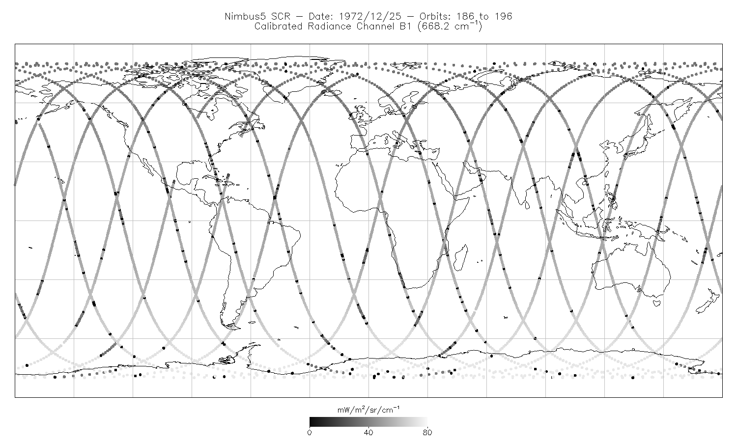
SCR/Nimbus-5 Level 1 Calibrated Radiances V001 (SCRN5L1RAD) at GES DISC
National Aeronautics and Space Administration —
SCRN5L1RAD is the Nimbus-5 Selective Chopper Radiometer (SCR) Level 1 Calibrated Radiances data product. The calibrated radiances are measured at 16 channels from 2.3... -
Federal
BUV/Nimbus-4 Dark Current Study Master Data V001 (BUVN4L1DCM) at GES DISC
National Aeronautics and Space Administration —
The Nimbus-4 BUV Level-1 Dark Current Study Master Data is derived from the BUV Level 1 Radiance (RUT) product and contains the geophysical indices and... -
Federal
VISSR/SMS-2 Level 1 Atmospheric and Oceanographic Image Processing System (AOIPS) Data V001 (VISSRSMS2L1AOIPS) at GES DISC
National Aeronautics and Space Administration —
VISSRSMS2L1AOIPS is the Visible Infrared Spin-Scan Radiometer (VISSR) Level 1 Atmospheric and Oceanographic Image Processing System (AOIPS) data product from the... -
Federal
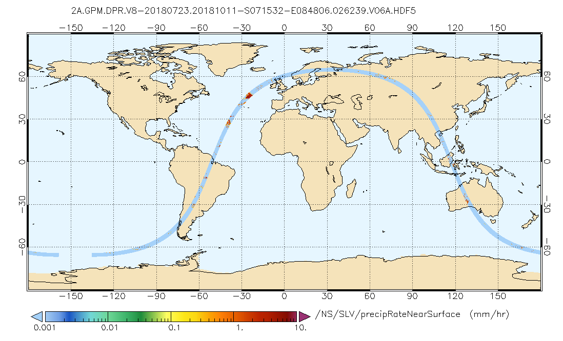
GPM DPR Precipitation Profile L2A 1.5 hours 5 km V07 (GPM_2ADPR) at GES DISC
National Aeronautics and Space Administration —
Version 07 is the current version of the data set. Older versions will no longer be available and have been superseded by Version 07..2ADPR provides single- and dual-... -
Federal
SAFARI 2000 Land Cover from AVHRR, 8-km, 1984 (DeFries et al.)
National Aeronautics and Space Administration —
This data set consists of a southern African subset of the University of Maryland (UMD) 8-km Global Land Cover product in ASCII GRID and binary image files formats.... -
Federal
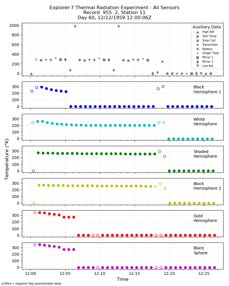
Explorer-7 Thermal Radiation Experiment Temperature Values from All Sensors V001 (EXP7L1TRTALL) at GES DISC
National Aeronautics and Space Administration —
Explorer-7 Thermal Radiation Experiment Temperature Values from All Sensors product contains temperature readings from all five bolometers in order to measure solar,... -
Federal
SE-590 Ground Data: UNL (FIFE)
National Aeronautics and Space Administration —
The SE-590 Reflectance Factors and Radiances from UNL Data Set contains surface reflectance and viewing angle data that was collected at three sites within the FIFE... -
Federal
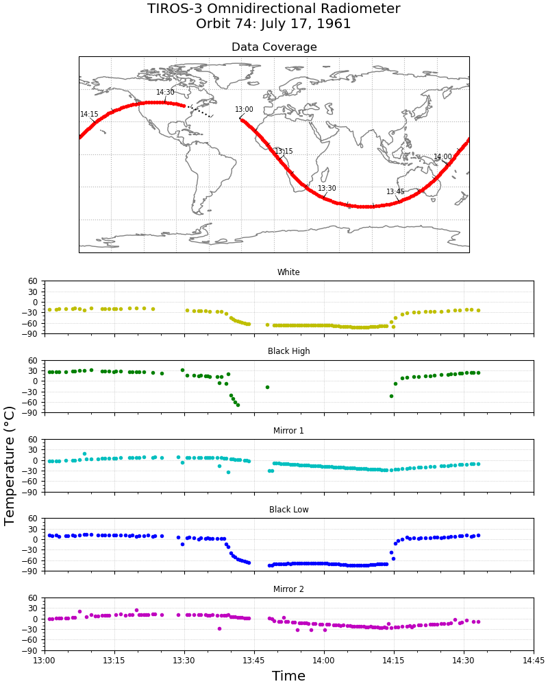
TIROS-3 Low-Resolution Omnidirectional Radiometer Level 1 Temperature Data V001 (TIROS3L1ORT) at GES DISC
National Aeronautics and Space Administration —
The TIROS-3 Low-Resolution Omnidirectional Radiometer Level 1 Temperature Data product contains the black and white sensor temperature values in degrees Celsius. The... -
Federal
GEOS-2 International Optical Beacon Data Input V001 (GEOS2OBSINPUTINTL) at GES DISC
National Aeronautics and Space Administration —
GEOS2OBSINPUTINTL is the optical beacon system data product which contains reduced raw geodetic optical observations obtained by various international camera systems.... -
Federal
LIMS/Nimbus-7 Level 1 Profiles of Radiance Data V001 (LIMSN7L1PROFILER) at GES DISC
National Aeronautics and Space Administration —
LIMSN7L1PROFILER is the Nimbus-7 Limb Infrared Monitor of the Stratosphere (LIMS) Level-1 Profiles of Radiance Data product and contains selected daily vertical... -
Federal
CYGNSS Level 1 Science Data Record Version 3.0
National Aeronautics and Space Administration —
This Level 1 (L1) dataset contains the Version 3.0 geo-located Delay Doppler Maps (DDMs) calibrated into Power Received (Watts) and Bistatic Radar Cross Section... -
Federal
HIRS/Nimbus-6 Level 1 Calibrated Radiances for the Global Atmospheric Research Program (GARP) V001 (HIRSN6L1GARP) at GES DISC
National Aeronautics and Space Administration —
The Nimbus-6 High Resolution Infrared Radiometer (HIRS) Level 1 Calibrated Radiances for the Global Atmospheric Research Program (GARP) data product contains daily... -
Federal
THIR/Nimbus-5 Level 1 Meteorological Radiation Data at 11.5 microns V001 (THIRN5L1CH115) at GES DISC
National Aeronautics and Space Administration —
THIRN5L1CH115 is the Nimbus-5 Temperature-Humidity Infrared Radiometer (THIR) Level 1 Meteorological Radiation Data at 11.5 microns product and contains radiances... -
Federal
CYGNSS Level 3 Science Data Record Version 2.1
National Aeronautics and Space Administration —
This dataset contains the Version 2.1 CYGNSS Level 3 Science Data Record which provides the average wind speed and mean square slope (MSS) on a 0.2x0.2 degree... -
Federal
SARP 2017 Data
National Aeronautics and Space Administration —
SARP_2017_Data is the data collected onboard the Wallops C-23 aircraft during the 2017 deployment of the Student Airborne Research Program (SARP) mission. Data...

Official websites use .gov
A
.gov website belongs to an official government
organization in the United States.
Secure .gov websites use HTTPS
A
lock (
) or https:// means you’ve safely connected to
the .gov website. Share sensitive information only on official,
secure websites.