
-
Federal
ORACLES Aerosol Cloud Aircraft Remote Sensing Data
National Aeronautics and Space Administration —
ORACLES_AerosolCloud_AircraftRemoteSensing_Data are remotely sensed aerosol and cloud measurements collected onboard the P-3 Orion or ER-2 aircraft during the... -
Federal
SAFARI 2000 TOMS Tropospheric Ozone Data, Southern Africa Subset, Dry Season 2000
National Aeronautics and Space Administration —
Tropical Tropospheric Ozone (TTO) data from Earth Probe (EP) Total Ozone Mapping Spectrometer (TOMS) for the period of August 8-September 29, 2000 were processed and... -
Federal
SAFARI 2000 MAPSS MOD04_L2 Aerosol Summary Data for Southern Africa
National Aeronautics and Space Administration —
The Moderate Resolution Imaging Spectroradiometer (MODIS)Atmosphere Group develops remote sensing algorithms for deriving sets of atmospheric parameters from MODIS... -
Federal
SAFARI 2000 Mean Climatology, 0.5-Deg, 1930-1960, V[ersion]. 2.1 (Cramer and Leemans)
National Aeronautics and Space Administration —
This data set is a subset of the global mean monthly climatology (Cramer and Leemans 1999). The subset is for the area of southern Africa within the following bounds:... -
Federal
SAFARI 2000 Micro-Pulse Lidar Cloud and Aerosol Data, Dry Season 2000
National Aeronautics and Space Administration —
Two Micro-Pulse Lidar (MPL) systems were deployed to Africa for the SAFARI 2000 experiment. One MPL was setup in Mongu, Zambia and the other was setup in Skukuza,... -
Federal
AfriSAR LVIS L2 Geolocated Surface Elevation Product V001
National Aeronautics and Space Administration —
This data set contains surface elevation data over Gabon, Africa. The measurements were taken by the NASA Land, Vegetation, and Ice Sensor (LVIS), an airborne lidar... -
Federal
ORACLES Navigational and Meteorological Data
National Aeronautics and Space Administration —
ORACLES_MetNav_AircraftInSitu_Data are in situ meteorological and navigational measurements collected onboard the P-3 Orion or ER-2 aircraft during the ObseRvations... -
Federal
Measurements from the Ligurian Sea
National Aeronautics and Space Administration —
Measurements taken in the Mediterranean Sea, the Ligurian Sea near Northern Italy and Southern France, and off the western coast of South Africa. -
Federal
SAFARI 2000 Meteorological and Flux Tower Measurements in Maun, Botswana, 2000
National Aeronautics and Space Administration —
To investigate potential contributions of savanna ecosystems to the Earth s carbon balance, an eddy covariance system was used to measure the seasonal variation in... -
Federal
SAFARI 2000 AERONET Ground-based Aerosol Data, Dry Season 2000
National Aeronautics and Space Administration —
AERONET (AErosol RObotic NETwork) is an optical ground-based aerosol monitoring network and data archive system. AERONET measurements of the column-integrated aerosol... -
Federal
SAFARI 2000 C-130 Aerosol and Meteorological Data, Dry Season 2000
National Aeronautics and Space Administration —
The Met Office C-130 research aircraft was based at Windhoek, Namibia between September 5-16, 2000, where it conducted a series of flights over Namibia as part of the... -
Federal
Aerosol Characterization Experiment (ACE)
National Aeronautics and Space Administration —
Measurements taken during the Aerosol Characterization Experiment (ACE) off the coast of Spain, Portugal, and Northern Africa in the Atlantic Ocean. -
Federal
CAR SKUKUZA BRDF Measurements L1 V2 (CAR_SKUKUZA_BRDF) at GES DISC
National Aeronautics and Space Administration —
CAR mission Skukuza measured bidirectional reflection functions over different natural surfaces and ecosystems in southern Africa. The measurements were conducted to... -
Federal
SAFARI 2000 Tree Cover from AVHRR, 1-km, 1992-1993 (DeFries et al.)
National Aeronautics and Space Administration —
The data set consists of a southern Africa subset of the 1km Global Tree Cover Data Set developed at the Laboratory for Global Remote Sensing Studies (LGRSS) at the... -
Federal
Spatio-temporal Characteristics of Rainfall in Africa, 0.25 degrees, from 1998-2012
National Aeronautics and Space Administration —
This data set describes rainfall distribution statistics over the African continent, including Madagascar. The rainfall estimates are based on data from the NASA... -
Federal
West Africa Coastal Vulnerability Mapping: Mangrove Forests Distribution, 2000 Polygon
National Aeronautics and Space Administration —
The West Africa Coastal Vulnerability Mapping: Mangrove Forests Distribution, 2000 Polygon data set was derived from the 30m resolution NASA Socioeconomic Data and... -
Federal
TRACE-A Merge Data
National Aeronautics and Space Administration —
TRACE-A_Merge_Data is merge data files created from data collected onboard the DC-8 aircraft during the Transport and Atmospheric Chemistry near the Equator -... -
Federal
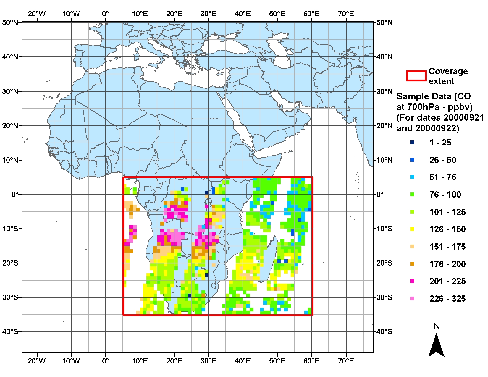
SAFARI 2000 MOPITT Tropospheric Carbon Monoxide, Southern Africa, Dry Season 2000
National Aeronautics and Space Administration —
The MOPITT (Measurements Of Pollution In The Troposphere) instrument on the NASA Terra Satellite makes measurements of infrared radiation originating from the surface...

Official websites use .gov
A
.gov website belongs to an official government
organization in the United States.
Secure .gov websites use HTTPS
A
lock (
) or https:// means you’ve safely connected to
the .gov website. Share sensitive information only on official,
secure websites.