
-
Federal
MODIS/Terra Land Surface Temperature/3-Band Emissivity Daily L3 Global 0.05Deg CMG V061
National Aeronautics and Space Administration —
A suite of Moderate Resolution Imaging Spectroradiometer (MODIS) Land Surface Temperature and Emissivity (LST&E) products are available in Collection 6.1. The... -
Federal
MODIS/Aqua Gross Primary Productivity Gap-Filled 8-Day L4 Global 500m SIN Grid V061
National Aeronautics and Space Administration —
The MYD17A2HGF Version 6.1 Gross Primary Productivity (GPP) Gap-Filled product is a cumulative 8-day composite of values with 500 meter (m) pixel size based on the... -
Federal
MLS/Aura Level 3 Monthly Binned Sulfur Dioxide (SO2) Mixing Ratio on Assorted Grids V005 (ML3MBSO2) at GES DISC
National Aeronautics and Space Administration —
ML3MBSO2 is the EOS Aura Microwave Limb Sounder (MLS) monthly binned on various vertical grids product for sulfur dioxide (SO2) derived from radiances measured by the... -
Federal
MLS/Aura Level 2 Hydroperoxy (HO2) Mixing Ratio V005 (ML2HO2) at GES DISC
National Aeronautics and Space Administration —
ML2HO2 is the EOS Aura Microwave Limb Sounder (MLS) standard product for hydroperoxy derived from radiances measured in two bands from the 640 GHz radiometer. The... -
Federal
Measurement of Air Pollution from Satellites (MAPS) Space Radar Laboratory - 1 (SRL1) Carbon Monoxide Second by Second data
National Aeronautics and Space Administration —
MAPS Overview The MAPS experiment measures the global distribution of carbon monoxide (CO) mixing ratios in the free troposphere. Because of MAPS' previous flights on... -
Federal
LBA-ECO LC-04 Macrohydrological Routing Data for the Amazon and Tocantins River Basin
National Aeronautics and Space Administration —
This data set provides continental-scale hydrological river flow routing parameter data for the Amazon and Tocantins River basins at 5 minute (~9 km) resolution... -
Federal
LANDMET Ancillary Monthly Mean Effective and Spectral Albedo Data L3 V1 (LANDMET_ANC_TESA) at GES DISC
National Aeronautics and Space Administration —
This is an ancillary product containing the total effective surface albedo at solar wavelengths originated from the ISCCP FD radiative fluxes product, and the... -
Federal
SAFARI 2000 Canopy Structural Measurements, Kalahari Transect, Wet Season 2001
National Aeronautics and Space Administration —
This data set contains leaf area index (LAI), leaf inclination angle, and canopy dimension data from study sites along the Kalahari Transect in southwest Botswana.... -
Federal
Polar Radiant Energy in the Far InfraRed Experiment (PREFIRE) Cloud Properties from PREFIRE Satellite 1 R01
National Aeronautics and Space Administration —
Polar Radiant Energy in the Far InfraRed Experiment (PREFIRE) Satellite 1 Cloud Properties (PREFIRE_SAT1_2B-CLD) contains cloud properties derived from data collected... -
Federal
Polar Radiant Energy in the Far InfraRed Experiment (PREFIRE) Satellite 2 Raw Curated Payload R01
National Aeronautics and Space Administration —
Polar Radiant Energy in the Far InfraRed Experiment (PREFIRE) Satellite 2 Raw Curated Radiance (PREFIRE_SAT2_0-PAYLOAD-TLM) contains the curated raw measurements from... -
Federal
PhenoCam Dataset v2.0: Digital Camera Imagery from the PhenoCam Network, 2000-2018
National Aeronautics and Space Administration —
This dataset provides a time series of visible-wavelength digital camera imagery collected through the PhenoCam Network at each of 393 sites predominantly in North... -
Federal
VIIRS/NPP Moderate Resolution Terrain Corrected Geolocation 6-Min L1 Swath 750m Light V001
National Aeronautics and Space Administration —
The VNP03MODLL Version 1 data product was decommissioned on July 31, 2025. Forward processing of VNP03MODLL Version 1 data product was discontinued on June 17, 2024.... -
Federal
VIIRS/NPP BRDF/Albedo Valid Observation Band M3 Daily L3 Global 30ArcSec CMG V001
National Aeronautics and Space Administration —
The VNP43D44 Version 1 data product was decommissioned on July 31, 2025. Users are encouraged to use the VNP43D44 and VJ143D44 Version 2 data products.The NASA/NOAA... -
Federal
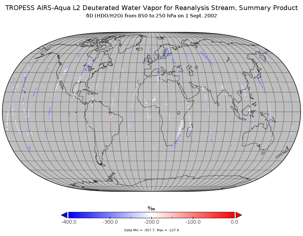
TROPESS AIRS-Aqua L2 Deuterated Water Vapor for Reanalysis Stream, Summary Product V1 (TRPSYL2HDOAIRSORS) at GES DISC
National Aeronautics and Space Administration —
The TROPESS AIRS-Aqua L2 Deuterated Water Vapor for Reanalysis Stream, Summary Product contains the vertical distribution of the retrieved atmospheric state of semi-... -
Federal
TROPICS05 L2A Unified Resolution Brightness Temperatures V0.2
National Aeronautics and Space Administration —
The "Time-Resolved Observations of Precipitation structure and storm Intensity with a Constellation of Smallsats" (TROPICS) mission has a goal of providing nearly... -
Federal
Sounder SIPS: Suomi NPP CrIMSS Level 2 CLIMCAPS Full Spectral Resolution: Atmospheric state at Standard Pressure Levels derived from CLIMCAPS V2.1 (SNDRSNIML2PLEVCPS) at GES DISC
National Aeronautics and Space Administration —
The CLIMCAPS (Community Long-term Infrared Microwave Coupled Product System) algorithm is used to analyze data from the Cross-track Infrared Sounder/Advanced... -
Federal
SBUV2/NOAA-19 Ozone (O3) Nadir Profile and Total Column 1 Day L2 V1 (SBUV2N19L2) at GES DISC
National Aeronautics and Space Administration —
The Solar Backscattered Ultraviolet (SBUV) from NOAA-19 Level-2 daily product (SBUV2N19L2) contains ozone nadir profile and total column data from retrievals... -
Federal
RLC Forest Fire Images in Russia, 1998-1999
National Aeronautics and Space Administration —
This data set is made up of images of forest fires in Russia from NOAA's Operational Significant Event Imagery (OSEI) archive (http://www.osei.noaa.gov) for the 1998...

Official websites use .gov
A
.gov website belongs to an official government
organization in the United States.
Secure .gov websites use HTTPS
A
lock (
) or https:// means you’ve safely connected to
the .gov website. Share sensitive information only on official,
secure websites.