
-
Federal
BUV/Nimbus-4 Level 2 High-Density Ozone Data V005 (BUVN4L2HDBUV) at GES DISC
National Aeronautics and Space Administration —
The Nimbus-4 BUV Level 2 High-Density Ozone Data collection contains the vertical distribtuion and total column amount of ozone, as well as the full set of ancillary... -
Federal
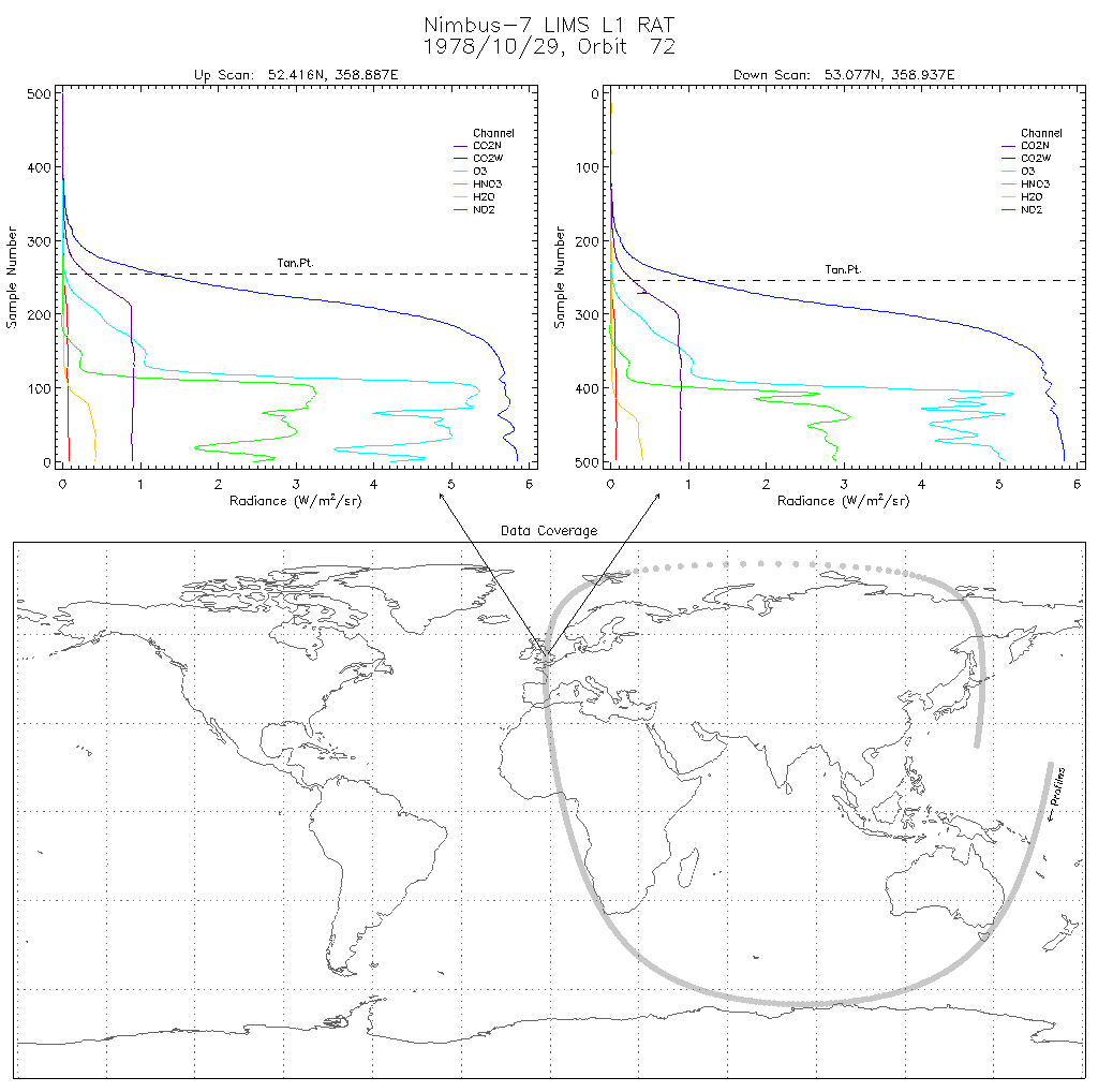
LIMS/Nimbus-7 Level 1 Radiance Data V001 (LIMSN7L1RAT) at GES DISC
National Aeronautics and Space Administration —
LIMSN7L1RAT is the Nimbus-7 Limb Infrared Monitor of the Stratosphere (LIMS) Level-1 Radiance Data product. It contains calibrated, earth-located radiances, as well... -
Federal
SARP 2019 Data
National Aeronautics and Space Administration —
SARP_2019_Data is the data collected onboard the NASA DC-8 aircraft during the 2019 deployment of the Student Airborne Research Program (SARP) mission. Data... -
Federal
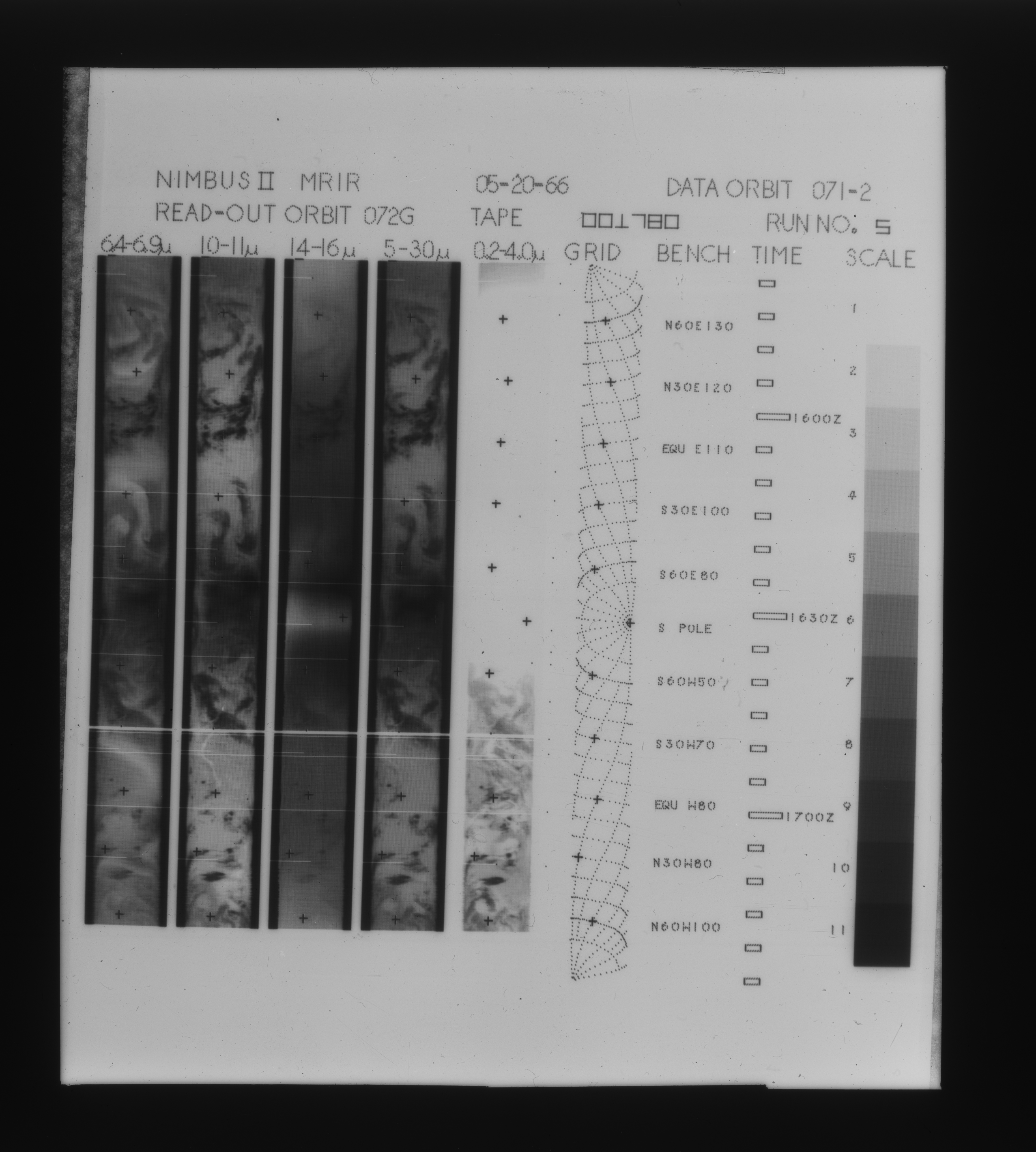
MRIR/Nimbus-2 Level 1 Meteorological Radiation Data V001 (MRIRN2L1) at GES DISC
National Aeronautics and Space Administration —
The Nimbus 2 Medium Resolution Infrared Radiometer (MRIR) was designed to measure electromagnetic radiation emitted and reflected from the earth and its atmosphere at... -
Federal
CYGNSS Level 2 Ocean Surface Heat Flux Science Data Record Version 3.2
National Aeronautics and Space Administration —
The CYGNSS level 2 ocean surface heat flux science data record version 3.2 dataset is provided as a service to the oceanographic and meteorological research... -
Federal
CYGNSS Level 1 Climate Data Record Version 1.1
National Aeronautics and Space Administration —
This Level 1 (L1) dataset contains the Version 1.1 Climate Data Record (CDR) of the geo-located Delay Doppler Maps (DDMs) calibrated into Power Received (Watts) and... -
Federal
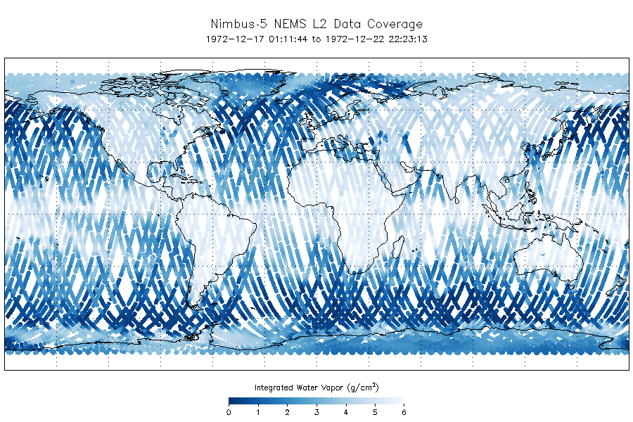
NEMS/Nimbus-5 Level 2 Output Data V001 (NEMSN5L2) at GES DISC
National Aeronautics and Space Administration —
NEMSN5L2 is the Nimbus-5 or Nimbus-E Microwave Spectrometer (NEMS) Level-2 Output Data product and contains surface reflectivity, water vapor, liquid water, layer... -
Federal
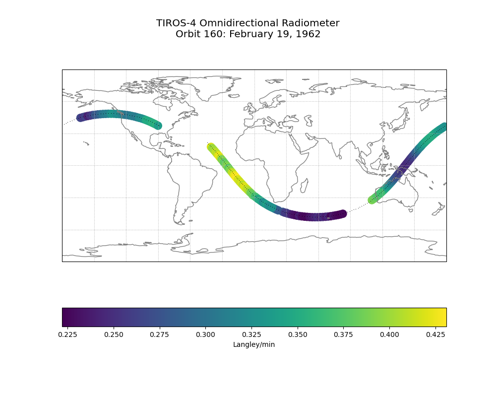
TIROS-4 Low-Resolution Omnidirectional Radiometer Level 1 Radiance Data V001 (TIROS4L1ORR) at GES DISC
National Aeronautics and Space Administration —
The TIROS-4 Low-Resolution Omnidirectional Radiometer Level 1 Radiance Data product contains the longwave radiation values in Langleys/min derived from the black and... -
Federal
Daily Great Lakes Ice Concentration, 1973 Onward, Version 1
National Aeronautics and Space Administration —
This data set consists of daily gridded lake ice concentration for the Laurentian Great Lakes from the NOAA Great Lakes Environmental Research Laboratory (GLERL). The... -
Federal
ESMR/Nimbus-5 Level 1 Calibrated Brightness Temperature V001 (ESMRN5L1) at GES DISC
National Aeronautics and Space Administration —
ESMRN5L1 is the Nimbus-5 Electrically Scanning Microwave Radiometer (ESMR) Level 1 Calibrated Brightness Temperature product and contains calibrated radiances... -
Federal
IRIS/Nimbus-4 Level 1 Radiance Data V001 (IRISN4RAD) at GES DISC
National Aeronautics and Space Administration —
The Nimbus-4 Infrared Interferometer Spectrometer (IRIS) Level 1 Radiance Data contain thermal emissions of the Earth's atmosphere at wave numbers between 400 and... -
Federal
CYGNSS Level 2 Ocean Surface Heat Flux Science Data Record Version 1.0
National Aeronautics and Space Administration —
This dataset contains the Version 1.0 CYGNSS Level 2 Ocean Surface Heat Flux Science Data Record, which provides the time-tagged and geolocated ocean surface heat... -
Federal
VISSR/GOES-1 Infrared Imagery on 70mm Film V001 (VISSRGOES1IMIR) at GES DISC
National Aeronautics and Space Administration —
VISSRGOES1IMIR is the Visible Infrared Spin-Scan Radiometer (VISSR) Infrared Imagery on 70mm Film data product from the first Geostationary Operational Environmental... -
Federal
SCR/Nimbus-5 Level 1 Calibrated Radiances V001 (SCRN5L1RAD) at GES DISC
National Aeronautics and Space Administration —
SCRN5L1RAD is the Nimbus-5 Selective Chopper Radiometer (SCR) Level 1 Calibrated Radiances data product. The calibrated radiances are measured at 16 channels from 2.3... -
Federal
BUV/Nimbus-4 Dark Current Study Master Data V001 (BUVN4L1DCM) at GES DISC
National Aeronautics and Space Administration —
The Nimbus-4 BUV Level-1 Dark Current Study Master Data is derived from the BUV Level 1 Radiance (RUT) product and contains the geophysical indices and... -
Federal
VISSR/SMS-2 Level 1 Atmospheric and Oceanographic Image Processing System (AOIPS) Data V001 (VISSRSMS2L1AOIPS) at GES DISC
National Aeronautics and Space Administration —
VISSRSMS2L1AOIPS is the Visible Infrared Spin-Scan Radiometer (VISSR) Level 1 Atmospheric and Oceanographic Image Processing System (AOIPS) data product from the... -
Federal
SAFARI 2000 Land Cover from AVHRR, 8-km, 1984 (DeFries et al.)
National Aeronautics and Space Administration —
This data set consists of a southern African subset of the University of Maryland (UMD) 8-km Global Land Cover product in ASCII GRID and binary image files formats.... -
Federal
Explorer-7 Thermal Radiation Experiment Temperature Values from All Sensors V001 (EXP7L1TRTALL) at GES DISC
National Aeronautics and Space Administration —
Explorer-7 Thermal Radiation Experiment Temperature Values from All Sensors product contains temperature readings from all five bolometers in order to measure solar,... -
Federal
SE-590 Ground Data: UNL (FIFE)
National Aeronautics and Space Administration —
The SE-590 Reflectance Factors and Radiances from UNL Data Set contains surface reflectance and viewing angle data that was collected at three sites within the FIFE... -
Federal
CYGNSS Level 3 Science Data Record Version 2.1
National Aeronautics and Space Administration —
This dataset contains the Version 2.1 CYGNSS Level 3 Science Data Record which provides the average wind speed and mean square slope (MSS) on a 0.2x0.2 degree...

Official websites use .gov
A
.gov website belongs to an official government
organization in the United States.
Secure .gov websites use HTTPS
A
lock (
) or https:// means you’ve safely connected to
the .gov website. Share sensitive information only on official,
secure websites.