
-
Federal
LUNAR TERRAIN AND ALBEDO RECONSTRUCTION FROM APOLLO IMAGERY
National Aeronautics and Space Administration —
LUNAR TERRAIN AND ALBEDO RECONSTRUCTION FROM APOLLO IMAGERY ARA V NEFIAN, TAEMIN KIM, MICHAEL BROXTON, AND ZACH MORATTO* Abstract. Generating accurate three... -
Federal
Gazetteer of Planetary Nomenclature: Uranian System: Puck
National Aeronautics and Space Administration —
These images display several of Uranus's moons approved by the International Astronomical Union (IAU). -
Federal
Gazetteer of Planetary Nomenclature: Asteroids: Ida
National Aeronautics and Space Administration —
These images display asteriods documented and approved by the International Astronomical Union (IAU). -
Federal
Gazetteer of Planetary Nomenclature: Moon: 1:1 million-scale maps of the Moon
National Aeronautics and Space Administration —
The purpose of the lunar maps is to provide an up-to-date and comprehensive depiction on lunar nomenclature approved by the International Astronomical Union (IAU). -
Federal
High-Resolution Radar Imagery, Digital Elevation Models, and Related GIS Layers for Barrow, Alaska, USA, Version 1
National Aeronautics and Space Administration —
This product set contains high-resolution Interferometric Synthetic Aperture Radar (IFSAR) imagery and geospatial data for the Barrow Peninsula (155.39 - 157.48 deg... -
Federal
Aircraft Scanners
National Aeronautics and Space Administration —
The National Aeronautics and Space Administration (NASA) Aircraft Scanners data set contains digital imagery acquired from several multispectral scanners, including... -
Federal
DAWN FC2 RAW (EDR) CERES IMAGES V1.0
National Aeronautics and Space Administration —
Abstract ======== Framing Camera 2 is one of two identical units flying on Dawn spacecraft. This data set includes the Experiment Data Record (EDR) version of all... -
Federal
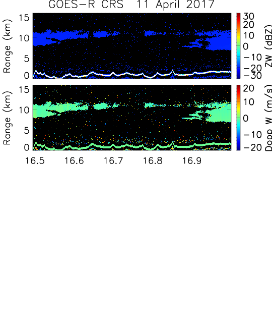
GOES-R PLT Cloud Radar System (CRS) V1
National Aeronautics and Space Administration —
The GOES-R PLT Field Campaign Cloud Radar System (CRS) dataset provides high-resolution profiles of reflectivity and Doppler velocity at aircraft nadir along the... -
Federal
AISRP Presentations
National Aeronautics and Space Administration —
AISRP Presentations from CIDU/AISRP 2009. -
Federal
Solar Data Analysis Center Data Finder
National Aeronautics and Space Administration —
An integrated resource of solar imagery and data. -
Federal
Mariner 10 Image Archive
National Aeronautics and Space Administration —
The Mariner 10 Image Archive includes tools to view shaded relief maps of the surface of Mercury, a 3D globe, and all images acquired by NASA's Mariner 10 mission. -
Federal
MESSENGER MDIS EXPERIMENT DATA RECORD V1.0
National Aeronautics and Space Administration —
Abstract ======== The Mercury Dual Imaging System (MDIS) consists of two cameras, a Wide Angle Camera (WAC) and a Narrow Angle Camera (NAC), mounted on a common pivot... -
Federal
CAMEX-3 LiDAR Atmospheric Sensing Experiment (LASE) Imagery V1
National Aeronautics and Space Administration —
The CAMEX-3 LiDAR Atmospheric Sensing Experiment (LASE) Imagery dataset is a browse-only dataset that consists of plotted reflectivity data collected by the LiDAR... -
Federal
IKONOS Level 1B Panchromatic Satellite Imagery
National Aeronautics and Space Administration —
The IKONOS Panchromatic Imagery collection contains satellite imagery acquired from Maxar Technologies (formerly known as DigitalGlobe) by the Commercial Smallsat... -
Federal
VIIRS/JPSS2 Imagery Resolution Terrain Corrected Geolocation 6-Min L1 Swath 375m NRT
National Aeronautics and Space Administration —
The Near Real Time (NRT) VIIRS/JPSS2 Imagery Resolution Terrain Corrected Geolocation 6-Min L1 Swath, short-name VJ203IMG_NRT is the Joint Polar-orbiting Satellite... -
Federal
VIIRS/NPP Surface Reflectance Daily L2G Global 1km and 500m SIN Grid V002
National Aeronautics and Space Administration —
The Visible Infrared Imaging Radiometer Suite (VIIRS) daily surface reflectance (VNP09GA) Version 2 product provides an estimate of land surface reflectance from the... -
Federal
Tropical Ozone Transport Experiment - Vortex Ozone Transport Experiment (TOTE-VOTE) Supplementary Satellite Data
National Aeronautics and Space Administration —
TOTE-VOTE_Satellite_Data_1 is the supplementary satellite data for the Tropical Ozone Transport Experiment – Vortex Ozone Transport Experiment (TOTE-VOTE) campaign.... -
Federal
NASADEM SRTM-only Height and Height Precision Mosaic Global 1 arc second V001
National Aeronautics and Space Administration —
The Land Processes Distributed Active Archive Center (LP DAAC) is responsible for the archive and distribution of NASA Making Earth System Data Records for Use in... -
Federal
Mars Rover Photos API
National Aeronautics and Space Administration —
This API is designed to collect image data gathered by NASA's Curiosity, Opportunity, and Spirit rovers on Mars and make it more easily available to other developers,...

Official websites use .gov
A
.gov website belongs to an official government
organization in the United States.
Secure .gov websites use HTTPS
A
lock (
) or https:// means you’ve safely connected to
the .gov website. Share sensitive information only on official,
secure websites.