
-
Federal
NGC 4472 Chandra X-Ray Point Source Catalog
National Aeronautics and Space Administration —
The Chandra X-Ray Point Source Catalog of the giant elliptical galaxy NGC 4472 contains the results of a Chandra ACIS-S/Hubble Space Telescope (HST) study of the... -
Federal
Spitzer Archival Far-Infrared Extragalactic Survey (SAFIRES) MIPS 70 micron Catalog
National Aeronautics and Space Administration —
The Spitzer Archival FIR Extragalactic Survey (SAFIRES) is an offshoot of the Spitzer Space Telescope Enhanced Imaging Products (SEIP). SAFIRES applies the SEIP... -
Federal
MLS/Aura Level 3 Daily Binned Relative Humidity With Respect To Ice (RHI) on Zonal and Similar Grids V004 (ML3DZRHI) at GES DISC
National Aeronautics and Space Administration —
ML3DZRHI is the EOS Aura Microwave Limb Sounder (MLS) daily binned on zonal and assorted vertical grids product for relative humidity with respect to ice (RHI)... -
Federal
MISR Level 3 Global Cloud public Product in netCDF format covering a day V002
National Aeronautics and Space Administration —
MI3DCLDN_2 is the Multi-angle Imaging SpectroRadiometer (MISR) Level 3 Global Cloud public Product in netCDF format covering a day version 2. It contains the public... -
Federal
MISR Level 3 FIRSTLOOK Component Global Albedo product covering a day V002
National Aeronautics and Space Administration —
MI3DALF_002 is the Multiangle Imaging SpectroRadiometer (MISR) Level 3 FIRST LOOK Component Global Albedo product covering a day version 2. It is intended to be used... -
Federal
MISR Ancillary Radiometric Product V002
National Aeronautics and Space Administration —
MIANCARP_2 is the Multi-angle Imaging SpectroRadiometer (MISR) Ancillary Radiometric Product version 2. It is composed of 4 files covering instrument characterization... -
Federal
Measurement of Air Pollution from Satellites (MAPS) Space Radar Laboratory - 1 (SRL1) Carbon Monoxide Second by Second data
National Aeronautics and Space Administration —
MAPS Overview The MAPS experiment measures the global distribution of carbon monoxide (CO) mixing ratios in the free troposphere. Because of MAPS' previous flights on... -
Federal
MODIS/Terra+Aqua BRDF/Albedo QA LocalSolarNoon Daily L3 Global 30ArcSec CMG V006
National Aeronautics and Space Administration —
The MCD43D32 Version 6 data product was decommissioned on July 31, 2023. Users are encouraged to use the MCD43D32 Version 6.1 data product.The MCD43D32 Version 6... -
Federal
MODIS/Terra+Aqua BRDF/Albedo Parameter2 Band2 Daily L3 Global 30ArcSec CMG V006
National Aeronautics and Space Administration —
The MCD43D05 Version 6 data product was decommissioned on July 31, 2023. Users are encouraged to use the MCD43D05 Version 6.1 data product.The MCD43D05 Version 6... -
Federal
MODIS/Terra+Aqua BRDF/Albedo Black Sky Albedo Band7 Daily L3 Global 30ArcSec CMG V006
National Aeronautics and Space Administration —
The MCD43D48 Version 6 data product was decommissioned on July 31, 2023. Users are encouraged to use the MCD43D48 Version 6.1 data product.The MCD43D48 Version 6... -
Federal
MODIS/Terra+Aqua BRDF/Albedo Nadir BRDF-Adjusted Ref Band2 Daily L3 Global 30ArcSec CMG V061
National Aeronautics and Space Administration —
The MCD43D63 Version 6.1 Bidirectional Reflectance Distribution Function and Albedo (BRDF/Albedo) Nadir BRDF-Adjusted Reflectance (NBAR) dataset is produced daily... -
Federal
MODIS/Terra+Aqua BRDF/Albedo Black Sky Albedo VIS Daily L3 Global 30ArcSec CMG V061
National Aeronautics and Space Administration —
The MCD43D49 Version 6.1 Bidirectional Reflectance Distribution Function and Albedo (BRDF/Albedo) Black-Sky Albedo dataset is produced daily using 16 days of Terra... -
Federal
MODIS/Terra+Aqua BRDF/Albedo Parameter1 Band4 Daily L3 Global 30ArcSec CMG V061
National Aeronautics and Space Administration —
The MCD43D10 Version 6.1 Bidirectional Reflectance Distribution Function and Albedo (BRDF/Albedo) Model Parameter dataset is produced daily using 16 days of Terra and... -
Federal
MASTER: Airborne Science, California-Nevada, August, 2004
National Aeronautics and Space Administration —
This dataset includes Level 1B (L1B) data products from the MODIS/ASTER Airborne Simulator (MASTER) instrument. The spectral data were collected during one flight... -
Federal
CERES and GEO-Enhanced TOA, Within-Atmosphere and Surface Fluxes, Clouds and Aerosols Monthly-Averaged 1-Hourly Terra-Aqua Edition4A
National Aeronautics and Space Administration —
CER_SYN1deg-MHour_Terra-Aqua-MODIS_Edition4A is the Clouds and the Earth's Radiant Energy System (CERES) and geostationary (GEO)-Enhanced Top-of-Atmosphere (TOA),... -
Federal
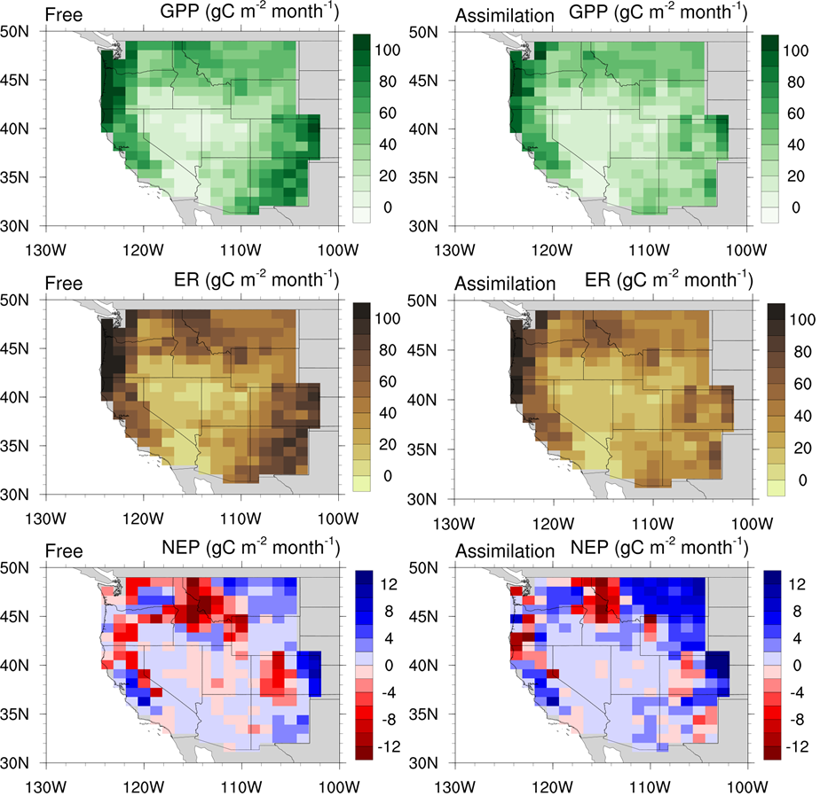
CLM5-DART Regional Carbon Fluxes and Stocks over the Western US, 1998-2010
National Aeronautics and Space Administration —
This dataset provides monthly estimates of biomass stocks and land-atmosphere carbon exchange across the western United States at 0.95 degrees longitude x 1.25... -
Federal
BOREAS TE-18 Landsat TM Physical Classification Image of the NSA
National Aeronautics and Space Administration —
The objective of this classification is to provide the BOREAS investigators with a data product that characterizes the land cover of the NSA. A Landsat-5 TM image... -
Federal
Active-Layer and Permafrost Temperatures, Soendre Stroemfjord, Greenland, Version 1
National Aeronautics and Space Administration —
This data set contains active-layer and permafrost temperatures from two stations in Soendre Stroemfjord, Greenland. Snow depth and snow extent were also recorded.... -
Federal
SAGE-SMC IRAC Epoch 0, Epoch 1, and Epoch 2 Catalog
National Aeronautics and Space Administration —
The SAGE-SMC pro ject is a Cycle 4 legacy program on the Spitzer Space Telescope, entitled, SAGE-SMC: Surveying the Agents of Galaxy Evolution in the Tidally-... -
Federal
GPM GROUND VALIDATION ACHIEVE W-BAND CLOUD RADAR IPHEX V1
National Aeronautics and Space Administration —
The GPM Ground Validation ACHIEVE W-band Cloud Radar IPHEx dataset consists of cloud and light precipitation radar observations gathered during the Global...

Official websites use .gov
A
.gov website belongs to an official government
organization in the United States.
Secure .gov websites use HTTPS
A
lock (
) or https:// means you’ve safely connected to
the .gov website. Share sensitive information only on official,
secure websites.