

593 datasets found
-
Federal
GOES-R PLT Kennedy Space Center Lightning Mapping Array (LMA) V1 recent views
National Aeronautics and Space Administration —
The GOES-R PLT Kennedy Space Center Lightning Mapping Array (LMA) dataset consists of total lightning data measured from the Kennedy Space Center LMA (KSCLMA) network... -
Federal
GPM GROUND VALIDATION METEOROLOGICAL TOWER ENVIRONMENT CANADA GCPEX V1 recent views
National Aeronautics and Space Administration —
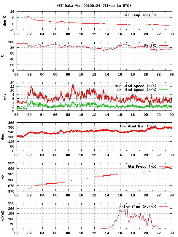
The GPM Ground Validation Meteorological Tower Environment Canada GCPEx dataset provides temperature, relative humidity, 10 m winds, pressure and solar radiation data... -
Federal
GOES-R PLT Oklahoma Lightning Mapping Array (LMA) V1 recent views
National Aeronautics and Space Administration —
The GOES-R PLT Oklahoma Lightning Mapping Array (LMA) dataset consists of total lightning data measured from the Oklahoma LMA (OKLMA) network during the GOES-R Post... -
Federal
GPM GROUND VALIDATION TWO-DIMENSIONAL VIDEO DISDROMETER (2DVD) GCPEX V1 recent views
National Aeronautics and Space Administration —
The GPM Ground Validation Two-Dimensional Video Disdrometer (2DVD) GCPEX dataset was collected by the Two-Dimensional Video Disdrometer (2DVD) data, which was... -
Federal
GPM Ground Validation Global Flood Monitoring System (GFMS) Flood Maps IFloodS V1 recent views
National Aeronautics and Space Administration —
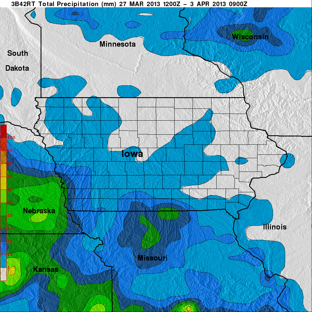
The GPM Ground Validation Global Flood Monitoring System (GFMS) Flood Maps IFloodS dataset contains global flood estimates on a 0.25 degree spatial resolution every 3... -
Federal
GOES-R PLT West Texas Lightning Mapping Array (LMA) V1 recent views
National Aeronautics and Space Administration —
The GOES-R PLT West Texas Lightning Mapping Array (LMA) dataset consists of total lightning data measured from the West Texas LMA (WTXLMA) network during the GOES-R... -
Federal
GPM GROUND VALIDATION DC-8 CAMERA NADIR GCPEX V1 recent views
National Aeronautics and Space Administration —
The GPM Ground Validation DC-8 Camera Nadir GCPEx dataset contains geo-located, visible-wavelength imagery of the ground obtained from the nadir camera aboard the... -
Federal
North Alabama Lightning Mapping Array (LMA) Raw Data V1 recent views
National Aeronautics and Space Administration —
The North Alabama Lightning Mapping Array (LMA) Raw Data are used to validate the Lightning Imaging Sensor (LIS) on the International Space Station (ISS), the... -
Federal
GPM Ground Validation SEA FLUX ICE POP V1 recent views
National Aeronautics and Space Administration —
The GPM Ground Validation SEA FLUX ICE POP dataset includes estimates of ocean surface latent and sensible heat fluxes, 10m wind speed, 10m air temperature, 10m air... -
Federal
GPM GROUND VALIDATION NOAA SURFACE METEOROLOGICAL STATION MC3E V1 recent views
National Aeronautics and Space Administration —
The GPM Ground Validation NOAA Surface Meteorological Station MC3E dataset was collected at the NOAA Southern Great Plains Facility for the Midlatitude Continental... -
Federal
CAMEX-3 LIGHTNING INSTRUMENT PACKAGE (LIP) V1 recent views
National Aeronautics and Space Administration —
The CAMEX-3 Lightning Instrument Package (LIP) dataset contains electrical field measurements of lightning within storms studied during the Convection And Moisture... -
Federal
ADVANCED MICROWAVE SOUNDING UNIT-A (AMSU-A) SWATH FROM NOAA-16 V1 recent views
National Aeronautics and Space Administration —
AMSU-A, the Advanced Microwave Sounding Unit, is a 15-channel passive microwave radiometer used to profile atmospheric temperature and moisture from the earth's...
593 datasets found