
-
Federal
Multispectral Imagery, NDVI, and Terrain Models, Big Trail Lake, Fairbanks, AK, 2019 recent views
National Aeronautics and Space Administration —
This dataset provides multispectral reflectance imagery (green at 550 nm, red at 660 nm, red edge at 735 nm, and near-infrared at 790 nm), normalized difference... -
Federal
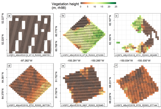
ABoVE: LVIS L3 Gridded Vegetation Structure across North America, 2017 and 2019 recent views
National Aeronautics and Space Administration —
This dataset provides Level 3 (L3) footprint-level gridded metrics and attributes collected from NASA's Land, Vegetation, and Ice Sensor (LVIS)-Facility instrument... -
Federal
Radarsat Antarctic Mapping Project Digital Elevation Model, Version 2 recent views
National Aeronautics and Space Administration —
The high-resolution Radarsat Antarctic Mapping Project (RAMP) Digital Elevation Model (DEM) combines topographic data from a variety of sources to provide consistent... -
Federal
Global Soil Profile Data (ISRIC-WISE) recent views
National Aeronautics and Space Administration —
The ISRIC-WISE International soil profile data set consists of a homogenized, global set of 1,125 soil profiles for use by global modelers. These profiles provided... -
Federal
ABoVE: Active Layer and Soil Moisture Properties from AirMOSS P-band SAR in Alaska recent views
National Aeronautics and Space Administration —
This dataset provides estimates of soil geophysical properties derived from Airborne Microwave Observatory of Subcanopy and Subsurface (AirMOSS) P-band polarimetric... -
Federal
ETM+ (1999-2003) recent views
National Aeronautics and Space Administration —
The USGS Earth Resources Observation and Science (EROS) Center archive holds data collected by the Landsat suite of satellites, beginning with Landsat 1 in 1972. All... -
Federal
ASTER Global Water Bodies Database Attributes NetCDF V001 NGDA recent views
National Aeronautics and Space Administration —
The ASTER Global Water Bodies Database (ASTWBD) Version 1 data product provides global coverage of water bodies larger than 0.2 square kilometers at a spatial... -
Federal
IceBridge Radar L3 Tomographic Ice Thickness V002 recent views
National Aeronautics and Space Administration —
This data set contains Level-3 tomographic ice thickness measurements and ice thickness errors over areas of Greenland and Antarctica. Two of the data files... -
Federal
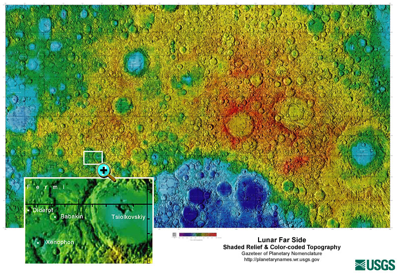
Gazetteer of Planetary Nomenclature: Moon: 1:10 million-scale Shaded Relief and Color-coded Topography: Far Side recent views
National Aeronautics and Space Administration —
These lunar maps display the four different areas of the moon with color-coded topography in low and high resolution approved by the International Astronomical Union... -
Federal
SENTINEL-1A_SINGLE_POL_GRD_FULL_RES recent views
National Aeronautics and Space Administration —
Sentinel-1A Single-pol ground range detected full resolution images -
Federal
GEDI L2A Elevation and Height Metrics Data Global Footprint Level V002 recent views
National Aeronautics and Space Administration —
The Global Ecosystem Dynamics Investigation (GEDI) mission aims to characterize ecosystem structure and dynamics to enable radically improved quantification and... -
Federal
RADARSAT-1_LEVEL0 recent views
National Aeronautics and Space Administration —
RADARSAT-1 Level 0 -
Federal
ASTER Orthorectified Digital Elevation Model (DEM) V003 NGDA recent views
National Aeronautics and Space Administration —
The ASTER Digital Elevation Model and Orthorectified Registered Radiance at the Sensor (AST14DMO) product... -
Federal
RADARSAT-1_LEVEL1 recent views
National Aeronautics and Space Administration —
RADARSAT-1 Level 1 Amplitude Images -
Federal
IceBridge HiCARS 1 L2 Geolocated Ice Thickness V001 recent views
National Aeronautics and Space Administration —
This data set contains ice thickness, surface and bed elevation, and echo strength measurements taken over Antarctica using the Hi-Capability Airborne Radar Sounder... -
Federal
Burned and Unburned Field Site Data, Noatak, Seward, and North Slope, AK, 2016-2018 recent views
National Aeronautics and Space Administration —
This dataset includes field measurements from unburned and burned 10 m x 10 m and 1 m x 1 m plots in the Noatak, Seward, and North Slope regions of the Alaskan tundra... -
Federal
Arctic Vegetation Plots at Umiat, North Slope, Alaska, 1951 recent views
National Aeronautics and Space Administration —
This data set provides vegetation cover and plot data collected during the periods of July and August, 1951, from 51 stands (areas of homogeneous vegetation... -
Federal
SENTINEL-1B_DUAL_POL_GRD_MEDIUM_RES recent views
National Aeronautics and Space Administration —
Sentinel-1B Dual-pol ground projected medium resolution images -
Federal
SMEX03 AMSR-E Daily Gridded Soil Moisture and Brightness Temperatures, Alabama, Version 1 recent views
National Aeronautics and Space Administration —
Notice to Data Users: The documentation for this data set was provided solely by the Principal Investigator(s) and was not further developed, thoroughly reviewed, or... -
Federal
ABoVE: Synthesis of Burned and Unburned Forest Site Data, AK and Canada, 1983-2016 recent views
National Aeronautics and Space Administration —
This dataset is a synthesis of field plot characterization data, derived above-ground and below-ground combusted carbon, and acquired Fire Weather Index (FWI) System...

Official websites use .gov
A
.gov website belongs to an official government
organization in the United States.
Secure .gov websites use HTTPS
A
lock (
) or https:// means you’ve safely connected to
the .gov website. Share sensitive information only on official,
secure websites.