
-
Federal
My NASA Data recent views
National Aeronautics and Space Administration —
MY NASA DATA (MND) is a tool that allows anyone to make use of satellite data that was previously unavailable.Through the use of MND’s Live Access Server (LAS) a... -
Federal
Daily and Annual PM2.5, O3, and NO2 Concentrations at ZIP Codes for the Contiguous U.S., 2000-2016, v1.0 recent views
National Aeronautics and Space Administration —
The Daily and Annual PM2.5, O3, and NO2 Concentrations at ZIP Codes for the Contiguous U.S., 2000-2016, v1.0 data set contains daily and annual concentration... -
Federal
Predicting Battery Life for Electric UAVs recent views
National Aeronautics and Space Administration —
This paper presents a novel battery health management technology for the new generation of electric unmanned aerial vehicles powered by long-life, high-density,... -
Federal
GLDAS Catchment Land Surface Model L4 daily 0.25 x 0.25 degree V2.0 (GLDAS_CLSM025_D) at GES DISC recent views
National Aeronautics and Space Administration —
NASA Global Land Data Assimilation System Version 2 (GLDAS-2) has three components: GLDAS-2.0, GLDAS-2.1, and GLDAS-2.2. GLDAS-2.0 is forced entirely with the... -
Federal
India Village-Level Geospatial Socio-Economic Data Set: 1991, 2001 recent views
National Aeronautics and Space Administration —
The India Village-Level Geospatial Socio-Economic Data Set: 1991, 2001 is a compilation of the finest level of administrative boundaries in India (village/town-level)... -
Federal
MERRA-2 tavg1_2d_slv_Nx: 2d,1-Hourly,Time-Averaged,Single-Level,Assimilation,Single-Level Diagnostics 0.625 x 0.5 degree V5.12.4 (M2T1NXSLV) at GES DISC recent views
National Aeronautics and Space Administration —
M2T1NXSLV (or tavg1_2d_slv_Nx) is an hourly time-averaged 2-dimensional data collection in Modern-Era Retrospective analysis for Research and Applications version 2... -
Federal
VIIRS NOAA-20 (JPSS-1) 375m, I-Band Active Fire Product NRT (Vector Data) recent views
National Aeronautics and Space Administration —
Near real-time (NRT) NOAA-20 (formally JPSS-1) Visible Infrared Imaging Radiometer Suite (VIIRS) Active Fire detection product is based on the instrument's 375 m... -
Federal
Global Vegetation Greenness (NDVI) from AVHRR GIMMS-3G+, 1981-2022 recent views
National Aeronautics and Space Administration —
This dataset holds the Global Inventory Modeling and Mapping Studies-3rd Generation V1.2 (GIMMS-3G+) data for the Normalized Difference Vegetation Index (NDVI). NDVI... -
Federal
Ocean Surface Current Analyses Real-time (OSCAR) Surface Currents - Final 0.25 Degree (Version 2.0) recent views
National Aeronautics and Space Administration —
Ocean Surface Current Analyses Real-time (OSCAR) is a global surface current database and NASA funded research project. OSCAR ocean mixed layer velocities are... -
Federal
ASTEROID NAMES AND DISCOVERY V7.0 recent views
National Aeronautics and Space Administration —
This data set lists name, designation(s), and discovery circumstances for all asteroids numbered as of the given stop date. It is compiled and maintain by David... -
Federal
LBA-ECO LC-14 Modeled Deforestation Scenarios, Amazon Basin: 2002-2050 recent views
National Aeronautics and Space Administration —
This data set provides the results of the two modeled scenarios for future patterns of deforestation across the Amazon Basin from 2002 to 2050. This larger defined... -
Federal
Identification of Spatial Fault Patterns in Semiconductor Wafers recent views
National Aeronautics and Space Administration —
Abstract The semiconductor industry is constantly searching for new ways to increase the rate of both process development and yield learning. As more data is being... -
Federal
Global Annual PM2.5 Grids from MODIS, MISR and SeaWiFS Aerosol Optical Depth (AOD), 1998-2019, V4.GL.03 NGDA recent views
National Aeronautics and Space Administration —
The Global Annual PM2.5 Grids from MODIS, MISR and SeaWiFS Aerosol Optical Depth (AOD), 1998-2019, V4.GL.03 consists of annual concentrations (micrograms per cubic... -
Federal
Global Maps of Atmospheric Nitrogen Deposition, 1860, 1993, and 2050 recent views
National Aeronautics and Space Administration —
This data set provides global gridded estimates of atmospheric deposition of total inorganic nitrogen (N), NHx (NH3 and NH4+), and NOy (all oxidized forms of nitrogen... -
Federal
Flight Crew Physiological Data for Crew State Monitoring recent views
National Aeronautics and Space Administration —
This physiological data was collected from pilot/copilot pairs in and out of a flight simulator. It was collected to train machine-learning models to aid in the... -
Federal
Black Hole - Neutron Star Binary Mergers recent views
National Aeronautics and Space Administration —
Gravitational radiation waveforms for black hole-neutron star coalescence calculations. The physical input is Newtonian physics, an ideal gas equation of state with... -
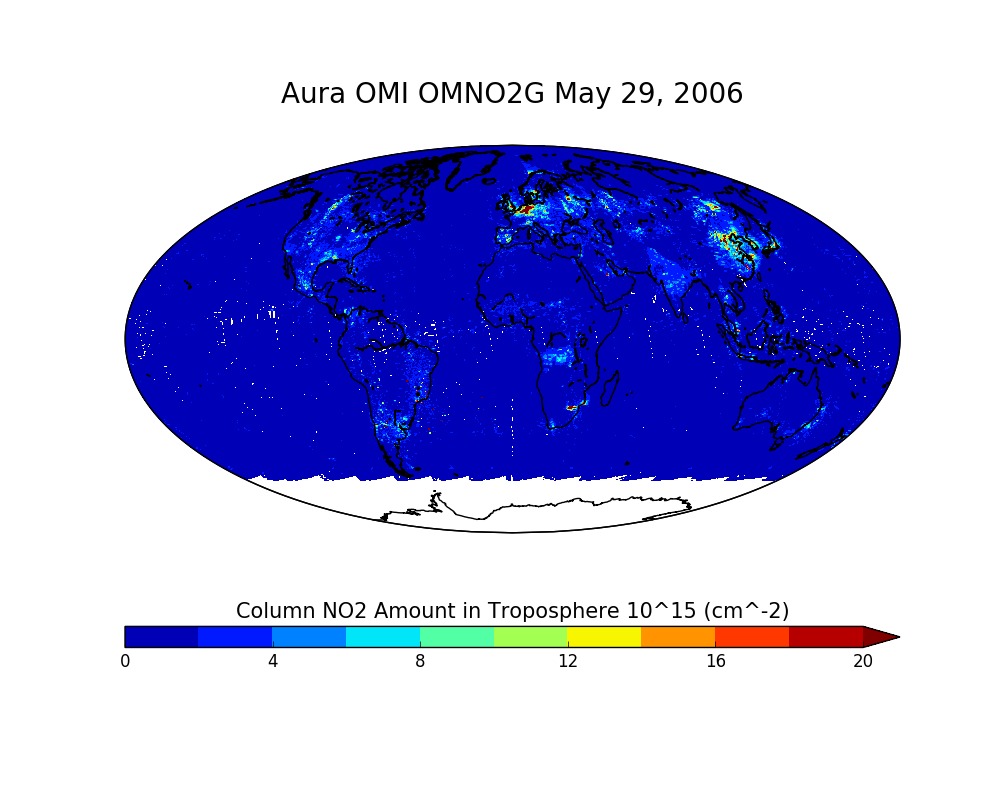
Federal
OMI/Aura NO2 Total and Tropospheric Column Daily L2 Global Gridded 0.25 degree x 0.25 degree V3 (OMNO2G) at GES DISC recent views
National Aeronautics and Space Administration —
This Level-2G daily global gridded product OMNO2G is based on the pixel level OMI Level-2 NO2 product OMNO2. OMNO2G data product is a special Level-2 Gridded Product... -
Federal
Global Land Cover Mapping and Estimation Yearly 30 m V001 recent views
National Aeronautics and Space Administration —
NASA’s Making Earth System Data Records for Use in Research Environments (MEaSUREs) Global Land Cover Mapping and Estimation (GLanCE) annual 30 meter (m) Version 1... -
Federal
SBIR/STTR Programs recent views
National Aeronautics and Space Administration —
The NASA SBIR and STTR programs fund the research, development, and demonstration of innovative technologies that fulfill NASA needs as described in the annual... -
Federal
GPM IMERG Final Precipitation L3 1 day 0.1 degree x 0.1 degree V07 (GPM_3IMERGDF) at GES DISC recent views
National Aeronautics and Space Administration —
Version 07 is the current version of the data set. Older versions will no longer be available and have been superseded by Version 07. The Integrated Multi-satellitE...

Official websites use .gov
A
.gov website belongs to an official government
organization in the United States.
Secure .gov websites use HTTPS
A
lock (
) or https:// means you’ve safely connected to
the .gov website. Share sensitive information only on official,
secure websites.