
-
Federal
NSCAT High Resolution R-MGDR, Selected Ocean Wind Vectors (JPL) recent views
National Aeronautics and Space Administration —
The NASA Scatterometer (NSCAT) Level 2.5 high-resolution reduced MGDR contains only wind vector data (sigma-0 is excluded) in 25 km wind vector cell (WVC) swaths... -
Federal
NSCAT Level 3 Daily Gridded Ocean Surface Wind Vectors (JPL) recent views
National Aeronautics and Space Administration —
The NASA Scatterometer (NSCAT) Level 3 daily gridded ocean wind vectors are provided at 0.5 degree spatial resolution for ascending and descending passes; wind... -
Federal
SASSIE Arctic Field Campaign Wave Glider Data Fall 2022 Version 1 recent views
National Aeronautics and Space Administration —
The Salinity and Stratification at the Sea Ice Edge (SASSIE) project is a NASA experiment that aims to understand how salinity anomalies in the upper ocean generated... -
Federal
Aquarius Official Release Level 3 Wind Speed Standard Mapped Image Descending 7-Day Data V5.0 recent views
National Aeronautics and Space Administration —
Aquarius Level 3 ocean surface wind speed standard mapped image data contains gridded 1 degree spatial resolution wind speed data averaged over daily, 7 day, monthly,... -
Federal
Aquarius Official Release Level 3 Wind Speed Standard Mapped Image Annual Data V5.0 recent views
National Aeronautics and Space Administration —
Aquarius Level 3 ocean surface wind speed standard mapped image data contains gridded 1 degree spatial resolution wind speed data averaged over daily, 7 day, monthly,... -
Federal
Aquarius Official Release Level 3 Wind Speed Standard Mapped Image Descending Seasonal Data V5.0 recent views
National Aeronautics and Space Administration —
Aquarius Level 3 ocean surface wind speed standard mapped image data contains gridded 1 degree spatial resolution wind speed data averaged over daily, 7 day, monthly,... -
Federal
Aquarius Official Release Level 3 Wind Speed Standard Mapped Image Ascending Seasonal Data V5.0 recent views
National Aeronautics and Space Administration —
Aquarius Level 3 ocean surface wind speed standard mapped image data contains gridded 1 degree spatial resolution wind speed data averaged over daily, 7 day, monthly,... -
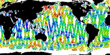
Federal
QuikSCAT Level 2B Ocean Wind Vectors in 12.5km Slice Composites Version 3 recent views
National Aeronautics and Space Administration —
This dataset contains the latest reprocessed version 3 of the Level 2B science-quality ocean surface wind vector retrievals from the QuikSCAT scatterometer. The... -
Federal
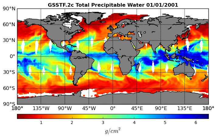
Goddard Satellite-Based Surface Turbulent Fluxes, 0.25 x 0.25 deg, Daily Grid V3 (GSSTF) at GES DISC recent views
National Aeronautics and Space Administration —
These data are the Goddard Satellite-based Surface Turbulent Fluxes Version-3 (GSSTF3) Dataset recently produced through a MEaSUREs funded project led by Dr. Chung-... -
Federal
Goddard Satellite-Based Surface Turbulent Fluxes, 1x1 deg Daily Grid, Satellite F13 V2c (GSSTF_F13) at GES DISC recent views
National Aeronautics and Space Administration —
These data are part of the Goddard Satellite-based Surface Turbulent Fluxes Version-2c (GSSTF 2c) Dataset recently produced through a MEaSURES funded project led by... -
Federal
Aquarius Official Release Level 3 Wind Speed Standard Mapped Image Ascending Daily Data V5.0 recent views
National Aeronautics and Space Administration —
Aquarius Level 3 ocean surface wind speed standard mapped image data contains gridded 1 degree spatial resolution wind speed data averaged over daily, 7 day, monthly,... -
Federal
QuikSCAT Level 1C Averaged Sigma-0 and Winds from Non-spinning Antenna Version 2.0 recent views
National Aeronautics and Space Administration —
This dataset is Version 2 of the geo-located and averaged Level 1B Sigma-0 measurements and wind retrievals from the SeaWinds on QuikSCAT platform, initiated in the... -
Federal
SASSIE Arctic Field Campaign L1 SWIFT Data Fall 2022 recent views
National Aeronautics and Space Administration —
The Salinity and Stratification at the Sea Ice Edge (SASSIE) project is a NASA experiment that aims to understand how salinity anomalies in the upper ocean generated... -
Federal
Aquarius Official Release Level 3 Wind Speed Standard Mapped Image Descending Monthly Data V5.0 recent views
National Aeronautics and Space Administration —
Aquarius Level 3 ocean surface wind speed standard mapped image data contains gridded 1 degree spatial resolution wind speed data averaged over daily, 7 day, monthly,... -
Federal
Aquarius Official Release Level 3 Wind Speed Standard Mapped Image Daily Data V5.0 recent views
National Aeronautics and Space Administration —
Aquarius Level 3 ocean surface wind speed standard mapped image data contains gridded 1 degree spatial resolution wind speed data averaged over daily, 7 day, monthly,... -
Federal
Aquarius Official Release Level 3 Wind Speed Standard Mapped Image Ascending Mission Cumulative Data V5.0 recent views
National Aeronautics and Space Administration —
Aquarius Level 3 ocean surface wind speed standard mapped image data contains gridded 1 degree spatial resolution wind speed data averaged over daily, 7 day, monthly,... -
Federal
Aquarius Official Release Level 3 Wind Speed Standard Mapped Image Ascending 28-Day Running Mean Data V5.0 recent views
National Aeronautics and Space Administration —
Aquarius Level 3 ocean surface wind speed standard mapped image data contains gridded 1 degree spatial resolution wind speed data averaged over daily, 7 day, monthly,... -
Federal
NSCAT Level 3 Daily Gridded Ocean Surface Wind Vector Browse Images (JPL) recent views
National Aeronautics and Space Administration —
This dataset provides browse images of the NASA Scatterometer (NSCAT) Level 3 daily gridded ocean wind vectors, which are provided at 0.5 degree spatial resolution... -
Federal
Aquarius Official Release Level 3 Wind Speed Standard Mapped Image Seasonal Data V5.0 recent views
National Aeronautics and Space Administration —
Aquarius Level 3 ocean surface wind speed standard mapped image data contains gridded 1 degree spatial resolution wind speed data averaged over daily, 7 day, monthly,... -
Federal
Aquarius Official Release Level 3 Wind Speed Standard Mapped Image Seasonal Climatology Data V5.0 recent views
National Aeronautics and Space Administration —
Aquarius Level 3 ocean surface wind speed standard mapped image data contains gridded 1 degree spatial resolution wind speed data averaged over daily, 7 day, monthly,...

Official websites use .gov
A
.gov website belongs to an official government
organization in the United States.
Secure .gov websites use HTTPS
A
lock (
) or https:// means you’ve safely connected to
the .gov website. Share sensitive information only on official,
secure websites.