
-
Federal
ABoVE: Passive Microwave-derived Annual Snowpack Main Melt Onset Date Maps, 1988-2023
National Aeronautics and Space Administration —
This dataset provides the annual date of snowpack seasonal beginning melt (i.e., main melt onset date, MMOD) across northwest Canada, Alaska, US, and parts of far... -
Federal
VIIRS/JPSS1 Land Surface Temperature and Emissivity 6-Min L2 Swath 750m V002
National Aeronautics and Space Administration —
The NOAA-20 Visible Infrared Imaging Radiometer Suite (VIIRS) Land Surface Temperature and Emissivity (LST&E) Version 2 swath product (VJ121) is produced daily in... -
Federal
VIIRS/NPP Land Surface Temperature and Emissivity 6-Min L2 Swath 750m V002
National Aeronautics and Space Administration —
The NASA/NOAA Suomi National Polar-orbiting Partnership (Suomi NPP) Visible Infrared Imaging Radiometer Suite (VIIRS) Land Surface Temperature and Emissivity... -
Federal
SWOT Level 2 Radiometer Brightness Temperatures and Troposphere Data Product
National Aeronautics and Space Administration —
The SWOT Level 2 Radiometer Brightness Temperatures and Troposphere Geophysical Data Record (GDR) dataset produced by the Surface Water and Ocean Topography (SWOT)... -
Federal
SWOT Level 2 Nadir Altimeter Interim Geophysical Data Record with Waveforms
National Aeronautics and Space Administration —
The SWOT Level 2 Nadir Altimeter Interim Geophysical Data Record (IGDR) Version 1.0 dataset produced by the Surface Water and Ocean Topography (SWOT) mission provides... -
Federal
NASADEM Merged DEM Global 1 arc second V001
National Aeronautics and Space Administration —
The Land Processes Distributed Active Archive Center (LP DAAC) is responsible for the archive and distribution of the NASA Making Earth System Data Records for Use in... -
Federal
GPM AMSR-2 on GCOM-W1 Common Calibrated Brightness Temperature L1C 1.5 hours 10 km V07 (GPM_1CGCOMW1AMSR2) at GES DISC
National Aeronautics and Space Administration —
Version 07 is the current version of the data set. Older versions will no longer be available and have been superseded by Version 07.1CAMSR2 contains common... -
Federal
GPM AMSR-2 on GCOM-W1 (GPROF) Radiometer Precipitation Profiling L3 1 month 0.25 degree x 0.25 degree V07 (GPM_3GPROFGCOMW1AMSR2) at GES DISC
National Aeronautics and Space Administration —
Version 07 is the current version of the data set. Older versions will no longer be available and have been superseded by Version 07.3GPROF products provide global... -
Federal
CYGNSS Level 1 Calibrated Raw IF Version 1.0
National Aeronautics and Space Administration —
The CYGNSS Level 1 Calibrated Raw IF Version 1.0 dataset is produced by the CYGNSS Science Team of the University of Michigan, and it contains the first release,... -
Federal
ASTER Global Water Bodies Database NetCDF V001
National Aeronautics and Space Administration —
The Terra Advanced Spaceborne Thermal Emission and Reflection Radiometer (ASTER) Global Water Bodies Database (ASTWBD) Version 1 data product provides global coverage... -
Federal
SWOT Level 2 Nadir Altimeter Geophysical Data Record with Waveforms
National Aeronautics and Space Administration —
The SWOT Level 2 Nadir Altimeter Geophysical Data Record (GDR) with Waveforms dataset produced by the Surface Water and Ocean Topography (SWOT) mission provides sea... -
Federal
CO2 and CH4 Fluxes from Waterbodies, Yukon-Kuskokwim Delta, Alaska, 2016-2019
National Aeronautics and Space Administration —
This dataset provides estimates of carbon dioxide (CO2) and methane (CH4) diffusive fluxes from waterbodies, and watershed landcover data for the central-interior of... -
Federal
VIIRS/JPSS1 Land Surface Temperature/Emissivity 8-Day L3 Global 0.05Deg CMG V002
National Aeronautics and Space Administration —
The NOAA-20 Visible Infrared Imaging Radiometer Suite (VIIRS) Land Surface Temperature and Emissivity (LST&E) 8-day Climate Modeling Grid Version 2 product... -
Federal
NASADEM Merged DEM Source Global 1 arc second nc V001
National Aeronautics and Space Administration —
The Land Processes Distributed Active Archive Center (LP DAAC) is responsible for the archive and distribution of the NASA Making Earth System Data Records for Use in... -
Federal
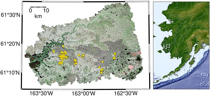
ABoVE: Lake and Pond Extents in Alaskan Boreal and Tundra Subregions, 2019-2021
National Aeronautics and Space Administration —
This dataset provides polygon spatial files of lake and pond extents for three sub-regions of Interior Alaska's boreal forest, and one tundra region located in... -
Federal
NASADEM Slope and Curvation Global 1 arc second V001
National Aeronautics and Space Administration —
The Land Processes Distributed Active Archive Center (LP DAAC) is responsible for the archive and distribution of NASA Making Earth System Data Records for Use in... -
Federal
ATLAS/ICESat-2 L3A Along Track Inland Surface Water Data Quick Look V006
National Aeronautics and Space Administration —
ATL13QL is the quick look version of ATL13. Once final ATL13 files are available the corresponding ATL13QL files will be removed. ATL13 contains along-track surface... -
Federal
SWOT Level 2 Radiometer Brightness Temperatures and Troposphere Interim Data Product
National Aeronautics and Space Administration —
The SWOT Level 2 Radiometer Brightness Temperatures and Troposphere Interim Geophysical Data Record (IGDR) Version 1.0 dataset produced by the Surface Water and Ocean... -
Federal
CSR TELLUS GRACE-FO Level-3 Monthly Ocean Bottom Pressure Anomaly Release 6.3 version 04
National Aeronautics and Space Administration —
This data set is produced by the Center for Space Research (CSR) GRACE-FO (Gravity Recovery and Climate Experiment Follow-On) program and derives the ocean bottom... -
Federal
Global Food Security-support Analysis Data (GFSAD) Cropland Extent 2015 Europe, Central Asia, Russia, Middle East product 30 m V001
National Aeronautics and Space Administration —
The NASA Making Earth System Data Records for Use in Research Environments (MEaSUREs) Global Food Security-support Analysis Data (GFSAD) data product provides...

Official websites use .gov
A
.gov website belongs to an official government
organization in the United States.
Secure .gov websites use HTTPS
A
lock (
) or https:// means you’ve safely connected to
the .gov website. Share sensitive information only on official,
secure websites.