
-
Federal
UAVSAR_POLSAR_ML_COMPLEX_GRD_5X5
National Aeronautics and Space Administration —
UAVSAR PolSAR Scene Projected Multilook 5x5 -
Federal
CAMEX-4 SHARED MOBILE ATMOSPHERIC RESEARCH AND TEACHING RADARS V1
National Aeronautics and Space Administration —
The CAMEX-4 Shared Mobile Atmospheric Research and Teching Radars dataset was collected by the Shared Mobile Atmospheric Research and Teaching Radar (SMART-R), which... -
Federal
UAVSAR_POLSAR_DEM
National Aeronautics and Space Administration —
UAVSAR PolSAR Scene DEM TIFF -
Federal
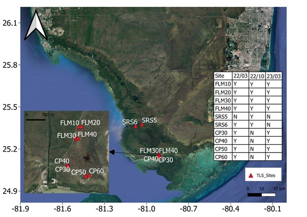
Blueflux: Terrestrial Lidar Scans of Mangrove Forests, Everglades, FL, USA, 2022-2023
National Aeronautics and Space Administration —
This dataset contains point clouds of three-dimensional (3D) mangrove forest structure and volume collected from 10 sites in Everglades National Park, Florida. Data... -
Federal
TRMM Ground Validation Radar Site 3D Rain Map L3 1 month 2 km V7 (TRMM_3A55) at GES DISC
National Aeronautics and Space Administration —
The 3A55, 'Monthly 3-D Structure', provides radar site monthly 3-D structure information obtained from 2A55. The 2A55 'Radar Site 3-D Reflectivities', is composed of... -
Federal
Measurements in Lake Okeechobee, Florida, 1997 - 1999
National Aeronautics and Space Administration —
Optical measurements made in Lake Okeechobee, Florida, between 1997 and 1999 -
Federal
CAMEX-4 ER-2 MICROWAVE TEMPERATURE PROFILER V1
National Aeronautics and Space Administration —
The CAMEX-4 ER-2 Microwave Temperature Profiler dataset was collected by the Microwave Temperature Profiler (MTP), which is a passive microwave radiometer which... -
Federal
A Multi University Research Initiative (MURI) Camouflage Project
National Aeronautics and Space Administration —
A Multi University Research Initiative was funded to study the biological response to the dynamic, polarized light field in distinct water types. During June 2010, a... -
Federal
CAMEX-3 DC-8 NAVIGATION (DADS) DATA V1
National Aeronautics and Space Administration —
The CAMEX-3 DC-8 Navigation Data Acquisition and Distribution System (DADS) data files contain information recorded by navigation and data collection systems onboard... -
Federal
SEDIMENT ANALYSIS NETWORK FOR DECISION SUPPORT (SANDS) LANDSAT GEOLOGICAL SURVEY OF AL (GSA) ANALYSIS V1
National Aeronautics and Space Administration —
The Sediment Analysis Network for Decision Support (SANDS) Landsat Geological Survey of AL (GSA) Analysis dataset analyzed changes in the coastal shoreline and... -
Federal
MASTER: BP Oil Spill Mapping, Louisiana-Gulf of America-Wisconsin, Fall, 2010
National Aeronautics and Space Administration —
This dataset includes Level 1B (L1B) and Level 2 (L2) data products from the MODIS/ASTER Airborne Simulator (MASTER) instrument. The raw data were collected during 9... -
Federal
Red tide measurements from Central Florida Gulf Coast
National Aeronautics and Space Administration —
Measurements from the Central Florida Gulf Coast in 1998 and 2005. -
Federal
West Florida Shelf measurements between 2005 and 2008
National Aeronautics and Space Administration —
Measurements made along the West Florida Shelf between 2005 and 2008. -
Federal
Optical Water quality measurements made in the Florida Panhandle estuaries
National Aeronautics and Space Administration —
Measurements made in the Florida Panhandle estuaries in partnership with USF and FWC-FWRI. -
Federal
Soil Carbon Estimates in 20-cm Layers to 1-meter Depth, Conterminous US, 1970-1993
National Aeronautics and Space Administration —
This data set provides a soil map with estimates of soil carbon (C) in g C/m2 for 20-cm layers from the surface to one meter depth for the conterminous United... -
Federal
AMPR BRIGHTNESS TEMPERATURE CAPE EXPERIMENT
National Aeronautics and Space Administration —
The Advanced Microwave Precipitation Radiometer (AMPR) was deployed during the Convection and Precipitation/Electrification Experiment (CaPE). AMPR data werecollected... -
Federal
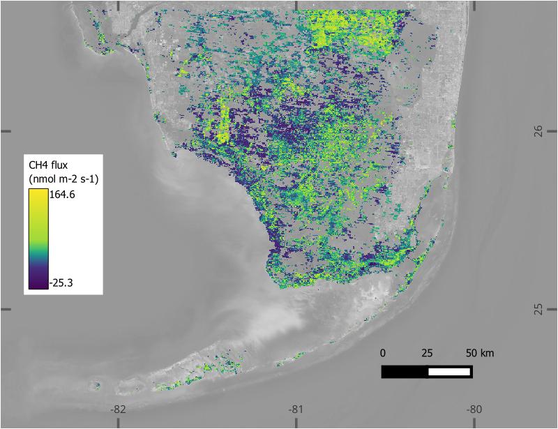
BlueFlux: Modeled Daily CO2 and CH4 Wetland Fluxes, Southern Florida, 2000-2024
National Aeronautics and Space Administration —
This dataset contains gridded estimates of carbon dioxide (CO2) and methane (CH4) fluxes at daily resolution covering the Southern Florida region from 2000 to 2024.... -
Federal
AMPR TEFLUN-A BRIGHTNESS TEMPERATURE (TB)
National Aeronautics and Space Administration —
The Advanced Microwave Precipitation Radiometer (AMPR) was deployed during the Texas-Florida Underflights (TEFLUN-A); the first of three TRMM ground validation... -
Federal
ACES CONTINUOUS DATA V1
National Aeronautics and Space Administration —
The ALTUS Cloud Electrification Study (ACES) was based at the Naval Air Facility Key West in Florida. During August, 2002, ACES researchers conducted overflights of... -
Federal
Benthic ecology measurements near Panama City and Florida Keys
National Aeronautics and Space Administration —
Measurements made near Panama City and the Florida Keys in 2005 and 2006.

Official websites use .gov
A
.gov website belongs to an official government
organization in the United States.
Secure .gov websites use HTTPS
A
lock (
) or https:// means you’ve safely connected to
the .gov website. Share sensitive information only on official,
secure websites.