
-
Federal
NACP New England and Sierra National Forests Biophysical Measurements: 2008-2010 recent views
National Aeronautics and Space Administration —
This data set includes biophysical measurements collected in 2009 from five New England experimental forest stations: Bartlett Experimental Forest, Harvard Forest,... -
Federal
BOREAS HYD-03 SSA/OLD Aspen DBH Data recent views
National Aeronautics and Space Administration —
The BOREAS HYD-03 team collected several data sets related to the hydrology of forested areas. This data set contains measurements of tree diameter at breast height... -
Federal
LBA-ECO CD-08 Tree Inventory Data, Ducke Reserve, Manaus, Brazil: 1999 recent views
National Aeronautics and Space Administration —
This data set includes in one data file the common names, base diameters, and calculated tree masses for almost 3,000 trees on a 5 hectare plot (20 x 2,500 m) located... -
Federal
LBA-ECO CD-08 Coarse Wood Litter Respiration and Decomposition, Manaus, Brazil recent views
National Aeronautics and Space Administration —
This data sets contains data on coarse wood density, moisture content, respiration rates and decomposition rate constants in csv format from Manaus Brazil measured... -
Federal
LBA-ECO CD-10 Ground-based Biometry Data at km 67 Tower Site, Tapajos National Forest recent views
National Aeronautics and Space Administration —
This data sets contains a single text file which reports biometry measurements of the old-growth upland forest at the Parao Western (Santarem) - km 67, Primary Forest... -
Federal
LBA-ECO ND-02 Secondary Forest Tree Heights and Diameters, Para, Brazil: 1999-2005 recent views
National Aeronautics and Space Administration —
This data set provides tree diameters and heights measured from 1999 to 2005 in plots of a secondary-growth forest fertilization experiment located 6.5-km northwest... -
Federal
ABoVE: Burn Severity, Fire Progression, Landcover and Field Data, NWT, Canada, 2014 NGDA recent views
National Aeronautics and Space Administration —
This data set provides peatland landcover classification maps, fire progression maps, and vegetation community biophysical data collected from areas that were burned... -
Federal
NARSTO Pacific 2001 Air Quality Study (PAC2001) Golden Ears Gaseous and Particulate Matter (PM) Data recent views
National Aeronautics and Space Administration —
NARSTO_PAC2001_GOLDEN_EARS_GAS_PM_DATA is the North American Research Strategy for Tropospheric Ozone (NARSTO) Pacific 2001 Air Quality Study (PAC2001) Golden Ears... -
Federal
SAFARI 2000 Woody Vegetation Characteristics of Kalahari and Skukuza Sites recent views
National Aeronautics and Space Administration —
This data set contains species composition, basal area, height, and crown cover of all woody plants at six sites along the Kalahari Transect visited in February-March... -
Federal
ECHIDNA LIDAR Campaigns: Forest Canopy Imagery and Field Data, U.S.A., 2007-2009 recent views
National Aeronautics and Space Administration —
This data set contains forest canopy scan data from the Echidna? Validation Instrument (EVI) and field measurements data from three campaigns conducted in the United... -
Federal
AfriSAR: Aboveground Biomass for Lope, Mabounie, Mondah, and Rabi Sites, Gabon recent views
National Aeronautics and Space Administration —
This dataset provides gridded estimates of aboveground biomass (AGB) for four sites in Gabon at 0.25 ha (50 m) resolution derived with field measurements and airborne... -
Federal
Biomass of Sacrificed Spruce/Aspen (SNF) recent views
National Aeronautics and Space Administration —
Dimension analysis (diameter at breast high, tree height, depth of crown), estimated leaf area, and total aboveground biomass for sacrificed spruce and aspens in... -
Federal
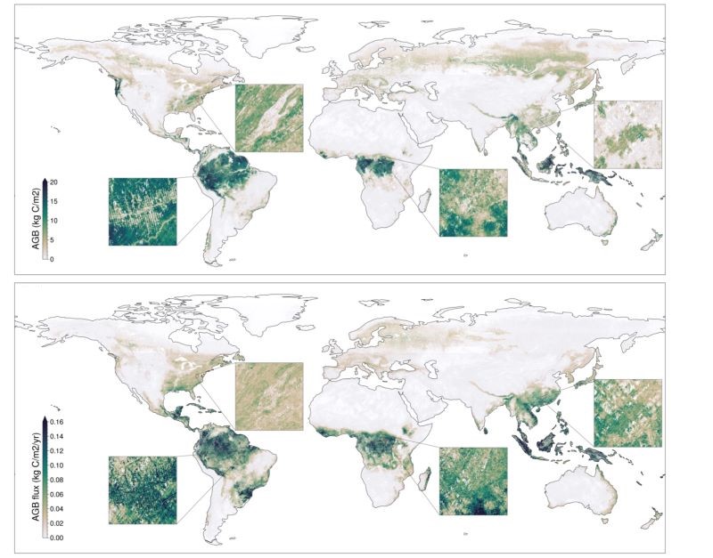
Global Forest Aboveground Carbon Stocks and Fluxes from GEDI and ICESat-2, 2018-2021 recent views
National Aeronautics and Space Administration —
This dataset provides global gridded estimates of forest aboveground carbon stocks and potential fluxes at a 0.01-degree resolution. It was derived by initializing a... -
Federal
LBA-ECO ND-11 Forest Damage Following Reduced Impact Logging, NW Mato Grosso, Brazil recent views
National Aeronautics and Space Administration —
Data were collected in the logging concession at the Fazenda Rohsamar in the municipality of Juruena in northwestern Mato Grosso. Estimates of damage associated with... -
Federal
NARSTO PAC2001 Langley Site Gaseous, Particle, and Meteorological Data recent views
National Aeronautics and Space Administration —
NARSTO_PAC2001_LANGLEY_GAS_PM_MET_DATA was obtained between August 8 and September 2, 2001 during the Pacific 2001 Air Quality Study (PAC2001).The Langley Ecole... -
Federal
Mirador - Water and Energy Cycles recent views
National Aeronautics and Space Administration —
Earth Science data access made simple. Through water and energy cycle research we can improve hurricane prediction, quantify tropical rainfall and eventually begin to... -
Federal
AfriSAR: Mondah Forest Tree Species, Biophysical, and Biomass Data, Gabon, 2016 recent views
National Aeronautics and Space Administration —
This dataset provides plot-level estimates of basal area, aboveground biomass, number of trees, maximum tree height, and basal-area-weighted wood specific gravity... -
Federal
GEDI L4C Footprint Level Waveform Structural Complexity Index, Version 2 recent views
National Aeronautics and Space Administration —
This dataset contains Global Ecosystem Dynamics Investigation (GEDI) Level 4C (L4C) Version 2 predictions ofthe Waveform Structural Complexity Index (WSCI) and... -
Federal
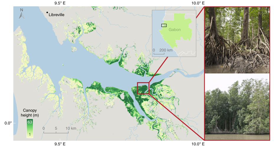
Global Mangrove Distribution, Aboveground Biomass, and Canopy Height recent views
National Aeronautics and Space Administration —
This dataset characterizes the global distribution, biomass, and canopy height of mangrove-forested wetlands based on remotely sensed and in situ field measurement... -
Federal
NACP Peatland Landcover Type and Wildfire Burn Severity Maps, Alberta, Canada recent views
National Aeronautics and Space Administration —
This data set provides landcover maps of (1) peatland type (bog, fen, marsh, swamp) with levels of biomass (open, forested) and (2) Burn Severity Index (BSI) (Dyrness...

Official websites use .gov
A
.gov website belongs to an official government
organization in the United States.
Secure .gov websites use HTTPS
A
lock (
) or https:// means you’ve safely connected to
the .gov website. Share sensitive information only on official,
secure websites.