
-
Federal
LOFAR Radio Catalog of Herschel-ATLAS North Galactic Pole Field
National Aeronautics and Space Administration —
This table contains some of the results of Low-Frequency Array (LOFAR) High-Band Array (HBA) observations of the Herschel-ATLAS North Galactic Pole (NGP) survey area.... -
Federal
ARC Code TI: Crisis Mapping Toolkit
National Aeronautics and Space Administration —
The Crisis Mapping Toolkit (CMT) is a collection of tools for processing geospatial data (images, satellite data, etc.) into cartographic products that improve... -
Federal
NICER Master Catalog
National Aeronautics and Space Administration —
This table records high-level information for the observations obtained with NICER (Neutron star Interior Composition ExploreR) and provides access to the NICER data... -
Federal
Gridded Population of the World, Version 3 (GPWv3): Land and Geographic Unit Area Grids
National Aeronautics and Space Administration —
The Gridded Population of the World, Version 3 (GPWv3): Land and Geographic Unit Area Grids measure land areas in square kilometers and the mean Unit size... -
Federal
Expandable Variable-Autonomy Architecture Project
National Aeronautics and Space Administration —
Effective multi-level autonomous piloting systems require integration with safety-critical functions. The Expandable Variable-Autonomy... -
Federal
West Africa Coastal Vulnerability Mapping: Point and Gridded Locations of Fatalities, 2008-2013
National Aeronautics and Space Administration —
The West Africa Coastal Vulnerability Mapping: Point and Gridded Locations of Fatalities, 2008-2013 data set consists of two layers: points representing the location... -
Federal
VG2 JUP PLS DERIVED ION IN/OUTBND MAGSHTH L-MODE 96SEC V1.0
National Aeronautics and Space Administration —
This data set contains plasma parameters from the Voyager 2 inbound magnetosheath and outbound data from the magnetotail through the solar wind. Inbound Voyager 2... -
Federal
Last of the Wild Project, Version 2, 2005 (LWP-2): Global Human Influence Index (HII) Dataset (IGHP)
National Aeronautics and Space Administration —
The Global Human Influence Index Dataset of the Last of the Wild Project, Version 2, 2005 (LWP-2) is a global dataset of 1-kilometer grid cells, created from nine... -
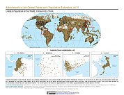
Federal
Gridded Population of the World, Version 4 (GPWv4): Administrative Unit Center Points with Population Estimates, Revision 11
National Aeronautics and Space Administration —
The Gridded Population of the World, Version 4 (GPWv4): Administrative Unit Center Points with Population Estimates, Revision 11 consists of UN WPP-adjusted... -
Federal
Gridded Population of the World, Version 3 (GPWv3): Centroids
National Aeronautics and Space Administration —
The Gridded Population of the World, Version 3 (GPWv3): Centroids consists of estimates of human population counts and densities for the years 1990, 1995, 2000, 2005,... -
Federal
LBA-ECO LC-09 Soil Composition and Structure in the Brazilian Amazon: 1992-1995
National Aeronautics and Space Administration —
This data set reports basic soil structure and composition information for five Amazonian research sites: Altamira, Bragantina, Tome-Acu, and Ponta de Pedras, all... -
Federal
Water Quality (WQ) monitoring program for Clear Lake, CA
National Aeronautics and Space Administration —
Clear Lake is a large, shallow, hypereutrophic lake in Northern California, USA. Clear Lake is an important water resource for the surrounding community offering many... -
Federal
Tidal Wetlands Soil Organic Carbon and Estuarine Characteristics, USA, 1972-2015
National Aeronautics and Space Administration —
This dataset provides a synthesis of soil organic carbon (SOC) estimates and a variety of other environmental information from tidal wetlands within estuaries in the... -
Federal
Across the Channel Investigating Diel Dynamics project
National Aeronautics and Space Administration —
The ACIDD (Across the Channel Investigating Diel Dynamics) project, in the Santa Barbara Channel, was initially designed to characterize daily variations in... -
Federal
GLIMPSE I Catalog
National Aeronautics and Space Administration —
The Galactic Legacy Infrared Mid-Plane Survey Extraordinaire (GLIMPSEI), using the Spitzer Space Telescope Infrared Array Camera (IRAC) surveyed approximately 220... -
Federal
Chandra Legacy Survey (CLS) Catalog
National Aeronautics and Space Administration —
The COSMOS-Legacy survey is a 4.6-Ms Chandra program that has imaged 2.2 deg2 of the COSMOS field with an effective exposure of ~160 ks over the central 1.5 deg2 and... -
Federal
Small Magellanic Cloud Deep Fields X-Ray Point Source Catalog
National Aeronautics and Space Administration —
This table contains the results of a pair of 100 ks Chandra observations of the Small Magellanic Cloud (SMC) to survey high-mass X-ray binaries (HMXBs), stars, and... -
Federal
ACCLIP WB-57 Aircraft In-Situ Aerosol Data
National Aeronautics and Space Administration —
ACCLIP_Aerosol_AircraftInSitu_WB57_Data is the in-situ aerosol data collected during the Asian Summer Monsoon Chemical & Climate Impact Project (ACCLIP). Data...

Official websites use .gov
A
.gov website belongs to an official government
organization in the United States.
Secure .gov websites use HTTPS
A
lock (
) or https:// means you’ve safely connected to
the .gov website. Share sensitive information only on official,
secure websites.