
-
Federal
Global Estimated Net Migration Grids by Decade: 1970-2000
National Aeronautics and Space Administration —
The Global Estimated Net Migration by Decade: 1970-2000 data set provides estimates of net migration over the three decades from 1970 to 2000. Because of the lack of... -
Federal
Global Volcano Total Economic Loss Risk Deciles
National Aeronautics and Space Administration —
Global Volcano Total Economic Loss Risk Deciles is a 2.5 minute grid of global volcano total economic loss risks. First, subnational distributions of Gross Domestic... -
Federal
U.S. Census Grids (Summary File 3), 2000
National Aeronautics and Space Administration —
The U.S. Census Grids (Summary File 3), 2000 data set contains grids of demographic and socioeconomic data from the year 2000 U.S. census in ASCII and GeoTIFF... -
Federal
Global Fertilizer and Manure, Version 1: Phosphorus in Manure Production
National Aeronautics and Space Administration —
The Phosphorus in Manure Production data set of the Global Fertilizer and Manure, Version 1 Data Collection represents the amount of phosphorous in manure produced... -
Federal
LOFAR 3C295 Field 62-MHz Source Catalog
National Aeronautics and Space Administration —
This table contains the source list from Low Frequency Array (LOFAR) Low Band observations of the 3C 295 field at 62 MHz. The images of this field and the Bootes... -
Federal
Spitzer Extragalactic First Look Survey R-band Source List
National Aeronautics and Space Administration —
The Extragalactic First Look Survey is composed of 4 square degrees of imaging with MIPS and IRAC centered at J1718+5930, with extensive ancillary data from ground-... -
Federal
Spitzer Wide-area InfraRed Extragalactic Survey CDFS MIPS 70 micron Catalog
National Aeronautics and Space Administration —
The Spitzer Wide-area InfraRed Extragalactic survey (SWIRE), the largest Spitzer Legacy program, is a wide-area, imaging survey to trace the evolution of dusty, star-... -
Federal
ABI G17 Deep Blue L3 Monthly Aerosol Data, 1 x 1 degree grid
National Aeronautics and Space Administration —
The ABI G17 Deep Blue L3 Monthly Aerosol Data, 1 x 1 degree grid product, short-name AERDB_M3_ABI_G17, derived by aggregating the L3 daily (AERDB_D3_ABI_G17) input... -
Federal
First ISCCP Regional Experiment (FIRE) Cirrus Phase II NCAR Sabreliner Aircraft Microphysical Data
National Aeronautics and Space Administration —
The First ISCCP Regional Experiments have been designed to improve data products and cloud/radiation parameterizations used in general circulation models (GCMs).... -
Federal
SDG Indicator 11.7.1: Urban Public Space, Availability and Access, 2023 Release
National Aeronautics and Space Administration —
The SDG Indicator 11.7.1: Urban Public Space, Availability and Access, 2023 Release, part of the SDGI collection, measures the average share of the built-up area of a... -
Federal
U.S. Climate Risk Projections by County, 2040-2049
National Aeronautics and Space Administration —
The U.S. Climate Risk Projections by County, 2040-2049 data set contains a projection for 2040-2049 risk for the entire contiguous U.S. at the county level with a... -
Federal
Global Population Density Grid Time Series Estimates
National Aeronautics and Space Administration —
The Global Population Density Grid Time Series Estimates provide a back-cast time series of population density grids based on the year 2000 population grid from... -
Federal
Georeferenced Population Datasets of Mexico (GEO-MEX): Population Database of Mexico
National Aeronautics and Space Administration —
The Population Database of Mexico contains geographically referenced population data for Mexican states, municipalities and localities from the 1990 Mexican... -
Federal
VLA Orion Nebula Cluster Compact Source Catalog
National Aeronautics and Space Administration —
This table contains a deep centimeter-wavelength catalog of the Orion Nebula Cluster (ONC), based on a 30-hr single-pointing observation with the Karl G. Jansky Very... -
Federal
GALEX/SDSS Quasar Catalog
National Aeronautics and Space Administration —
This table contains the result of an analysis of the broad-band UV and optical properties of z ~< 3.4 quasars matched in the Galaxy Evolution Explorer (GALEX)... -
Federal
Global Landslide Mortality Risks and Distribution
National Aeronautics and Space Administration —
The Global Landslide Mortality Risks and Distribution is a 2.5 minute grid of global landslide mortality risks. Gridded Population of the World, Version 3 (GPWv3)... -
Federal
Moderate Resolution Imaging Spectroradiometer (MODIS) - Aqua NGDA
National Aeronautics and Space Administration —
This dataset represents multiple products archived at the multiple archive centers for the MODIS (Moderate Resolution Imaging Spectroradiometer) instrument aboard the... -
Federal
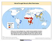
Global Drought Mortality Risks and Distribution
National Aeronautics and Space Administration —
The Global Drought Mortality Risks and Distribution is a 2.5 minute grid of global drought mortality risks. Gridded Population of the World, Version 3 (GPWv3) data... -
Federal
NorthAmerica(NGC7000)&Pelican(IC5070)NebulaeX-RaySourceCatalog
National Aeronautics and Space Administration —
This table contains some of the results from the first extensive X-ray study of the North-America and Pelican star-forming region (NGC 7000/IC 5070), with the aim of... -
Federal
Last of the Wild Project, Version 2, 2005 (LWP-2): Global Human Influence Index (HII) Dataset (IGHP)
National Aeronautics and Space Administration —
The Global Human Influence Index Dataset of the Last of the Wild Project, Version 2, 2005 (LWP-2) is a global dataset of 1-kilometer grid cells, created from nine...

Official websites use .gov
A
.gov website belongs to an official government
organization in the United States.
Secure .gov websites use HTTPS
A
lock (
) or https:// means you’ve safely connected to
the .gov website. Share sensitive information only on official,
secure websites.