
-
Federal
CERES Single Scanner Footprint (SSF) TOA/Surface Fluxes, Clouds and Aerosols Terra-FM1 Edition4A
National Aeronautics and Space Administration —
CER_SSF_Terra-FM1-MODIS_Edition4A is the Clouds and the Earth's Radiant Energy System (CERES) Single Scanner Footprint (SSF) Top-of-the-Atmosphere (TOA)/Surface... -
Federal
MODIS/Terra Cloud Mask and Spectral Test Results 5-Min L2 Swath 250m and 1km
National Aeronautics and Space Administration —
The MODIS/Terra Cloud Mask and Spectral Test Results 5-Min L2 Swath 250m and 1km product consists of global cloud mask quality assurance and other ancillary... -
Federal
VOYAGER 2 JUP PLASMA WAVE SPECTROMETER EDITED SPEC 4.0SEC
National Aeronautics and Space Administration —
This data set consists of 4-second edited, wave electric field intensities from the Voyager 2 Plasma Wave Receiver spectrum analyzer obtained in the vicinity of the... -
Federal
THIR/Nimbus-7 Images of Daytime and Nighttime Brightness Temperature on 70 mm Film V001 (THIRN7IM) at GES DISC
National Aeronautics and Space Administration —
THIRN7IM is the Nimbus-7 Temperature-Humidity Infrared Radiometer (THIR) data product consisting of daily montages of brightness temperatures measured at 6.7 and 11.5... -
Federal
TRACE-P Balloonsondes and Ozonesondes Data
National Aeronautics and Space Administration —
TRACE-P_Sondes_Data is the balloonsonde and ozonesonde data collected during the Transport and Chemical Evolution over the Pacific (TRACE-P) suborbital campaign. Data... -
Federal
Planck Catalog of Compact Sources 857GHz Catalog
National Aeronautics and Space Administration —
The Planck Catalogue of Compact Sources (PCCS) is a sample of reliable sources, both Galactic and extragalactic, extracted directly from the Planck nominal maps. The... -
Federal
Polar Ozone and Aerosol Measurement III
National Aeronautics and Space Administration —
POAM3 data are Polar Ozone and Aerosol Measurement III Version 3.0. The Polar Ozone and Aerosol Measurement (POAM) III instrument measures the vertical distribution... -
Federal
TROPICS03 L2B Deep Multispectral INtensity (DMIN) of Tropical cyclones estimator Algorithm V1.0
National Aeronautics and Space Administration —
The "Time-Resolved Observations of Precipitation structure and storm Intensity with a Constellation of Smallsats" (TROPICS) mission has a goal of providing nearly... -
Federal
CERES and GEO-Enhanced TOA, Within-Atmosphere and Surface Fluxes, Clouds and Aerosols Monthly-Averaged 1-Hourly Terra-Aqua Edition4A
National Aeronautics and Space Administration —
CER_SYN1deg-MHour_Terra-Aqua-MODIS_Edition4A is the Clouds and the Earth's Radiant Energy System (CERES) and geostationary (GEO)-Enhanced Top-of-Atmosphere (TOA),... -
Federal
GPM Ground Validation Conical Scanning Millimeter-wave Imaging Radiometer (CoSMIR) OLYMPEX
National Aeronautics and Space Administration —
The GPM Ground Validation Conical Scanning Millimeter-wave Imaging Radiometer (CoSMIR) OLYMPEX dataset consists of brightness temperatures from 9 channels as measured... -
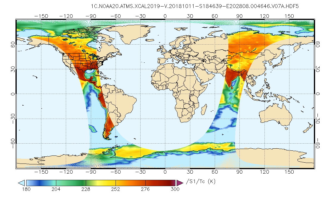
Federal
GPM ATMS on NOAA-20 Common Calibrated Brightness Temperatures L1C 1.5 hours 17 km V07 (GPM_1CNOAA20ATMS) at GES DISC
National Aeronautics and Space Administration —
Version 07 is the current version of the data set. Older versions will no longer be available and have been superseded by Version 07.1CATMS contains common calibrated... -
Federal
TRACE-P P-3B Trajectory Data
National Aeronautics and Space Administration —
TRACE-P_Trajectory_P3B_Data is the trajectory data collected onboard the P-3B aircraft during the Transport and Chemical Evolution over the Pacific (TRACE-P)... -
Federal
CERES and GEO-Enhanced TOA, Within-Atmosphere and Surface Fluxes, Clouds and Aerosols 1-Hourly Terra-Aqua Edition4A
National Aeronautics and Space Administration —
CER_SYN1deg-1Hour_Terra-Aqua-MODIS_Edition4A is the Clouds and the Earth's Radiant Energy System (CERES) and geostationary (GEO) Top-of-Atmosphere (TOA) Within-... -
Federal
MODIS/Terra Surface Reflectance 8-Day L3 Global 250m SIN Grid V006
National Aeronautics and Space Administration —
The MOD09Q1 Version 6 data product was decommissioned on July 31, 2023. Users are encouraged to use the MOD09Q1 Version 6.1 data product.The MOD09Q1 Version 6 product... -
Federal
Wind Radio/Plasma Wave, (WAVES) Hi-Res Parameters CDF
National Aeronautics and Space Administration —
Wind Waves RAD2, RAD1, and TNR data in CDF format. RAD1 RAD1 is the low frequency radio astronomy receiver. It sweeps over the range of 20 to 1040 kHz with as many as... -
Federal
IBEX High Energy Neutral Atom Imager (Hi) Data Release 04, Compton-Getting corrected, Survival Probability corrected, Omnidirectional, West Longitude Ecliptic Maps, Level H3 (H3), semiannually averaged Data
National Aeronautics and Space Administration —
1: The Interstellar Boundary Explorer (IBEX) has operated in space since 2008 updating our knowledge of the outer heliosphere and its interaction with the local... -
Federal
GPM MHS on METOP-B Common Calibrated Brightness Temperature L1C 1.5 hours 17 km V07 (GPM_1CMETOPBMHS) at GES DISC
National Aeronautics and Space Administration —
Version 07 is the current version of the data set. Older versions will no longer be available and have been superseded by Version 07.1CAMSR2 contains common... -
Federal
Polar Radiant Energy in the Far InfraRed Experiment (PREFIRE) Spectral Flux from PREFIRE Satellite 2 COG R01
National Aeronautics and Space Administration —
Polar Radiant Energy in the Far InfraRed Experiment (PREFIRE) Spectral Flux from PREFIRE Satellite 2 COG (PREFIRE_SAT2_2B-FLX_COG) is derived from data collected by... -
Federal
MMS 1 Electron Drift Instrument (EDI) Ambient Electron Flux, Projection Method 1 (PM1), Level 2 (L2), Burst Mode, 0.9765625 ms Data
National Aeronautics and Space Administration —
Electron Drift Instrument (EDI) Ambient Burst Survey, Level 2, 0.0009765625 s Data (1024 samples/s). EDI has two scientific data acquisition modes, called electric...

Official websites use .gov
A
.gov website belongs to an official government
organization in the United States.
Secure .gov websites use HTTPS
A
lock (
) or https:// means you’ve safely connected to
the .gov website. Share sensitive information only on official,
secure websites.