
-
Federal
ROSETTA-ORBITER 67P OSINAC 5 ESC3-MTP020 DDR-GEO V1.0
National Aeronautics and Space Administration —
This CODMAC level 5 data set contains derived data products that include pixel-precise georeferencing information, acquired by the OSIRIS Narrow Angle Camera on the... -
Federal
ROSETTA-ORBITER 67P RSI 1/2/3 COMET ESCORT 1 0513 V1.0
National Aeronautics and Space Administration —
This is a Rosetta Radio Science data set, collected during the COMET ESCORT 1 phase 2014-11-20 to 2015-03-10. It is a Global Gravity measurement at the comet 67P and... -
Federal
OMPS-NPP LP NRT Aerosol Extinction Vertical Profile swath multi-wavelength orbital 3slit
National Aeronautics and Space Administration —
The OMPS-NPP L2 LP Aerosol Extinction Vertical Profile swath l2 3slit (AER) product contains the retrieved aerosol extinction coefficients measured by the Ozone... -
Federal
NASA 3D Models: Jason 1
National Aeronautics and Space Administration —
Jason 1 is an oceanography mission to monitor global ocean circulation, study the ties between the oceans and atmosphere, improve global climate forecasts and... -
Federal
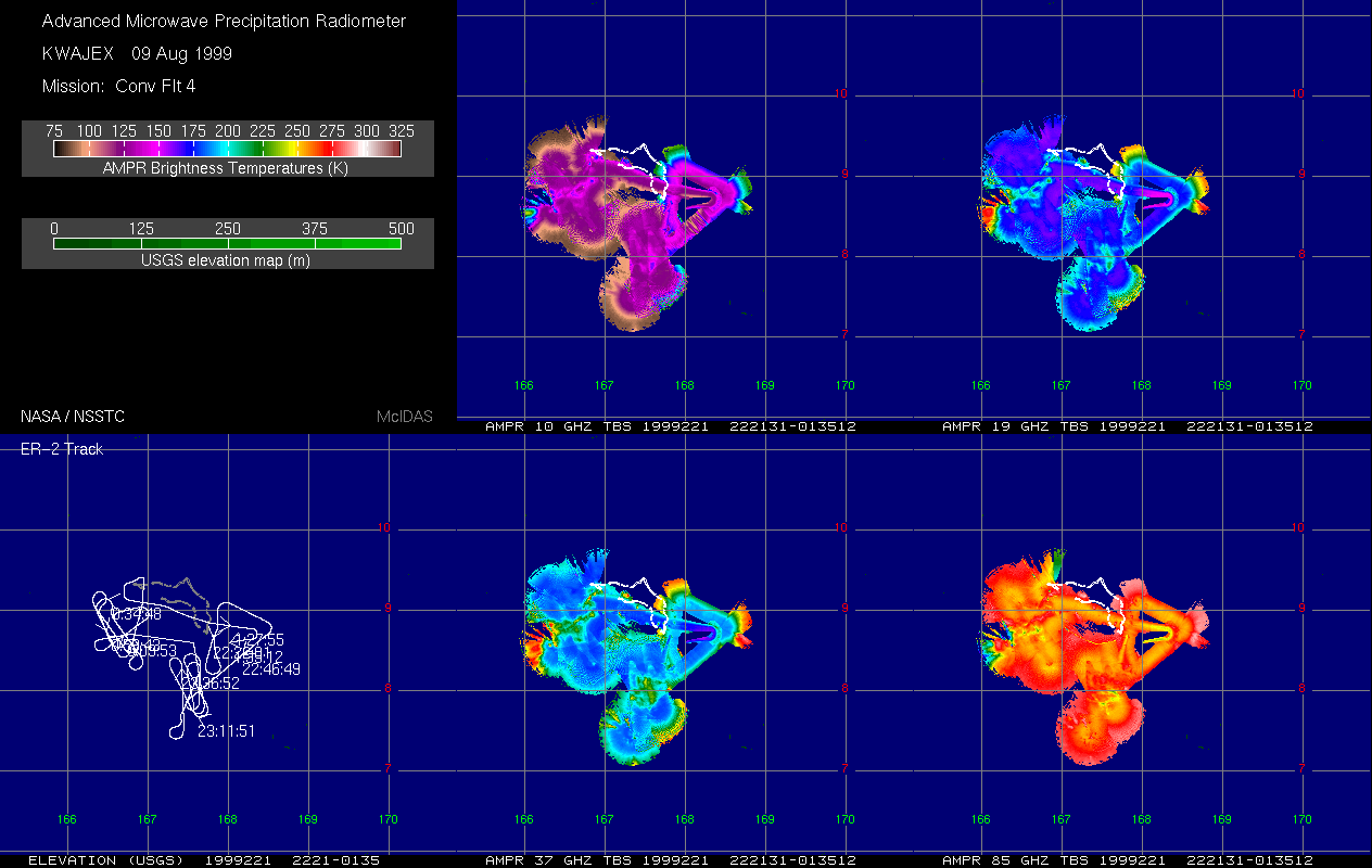
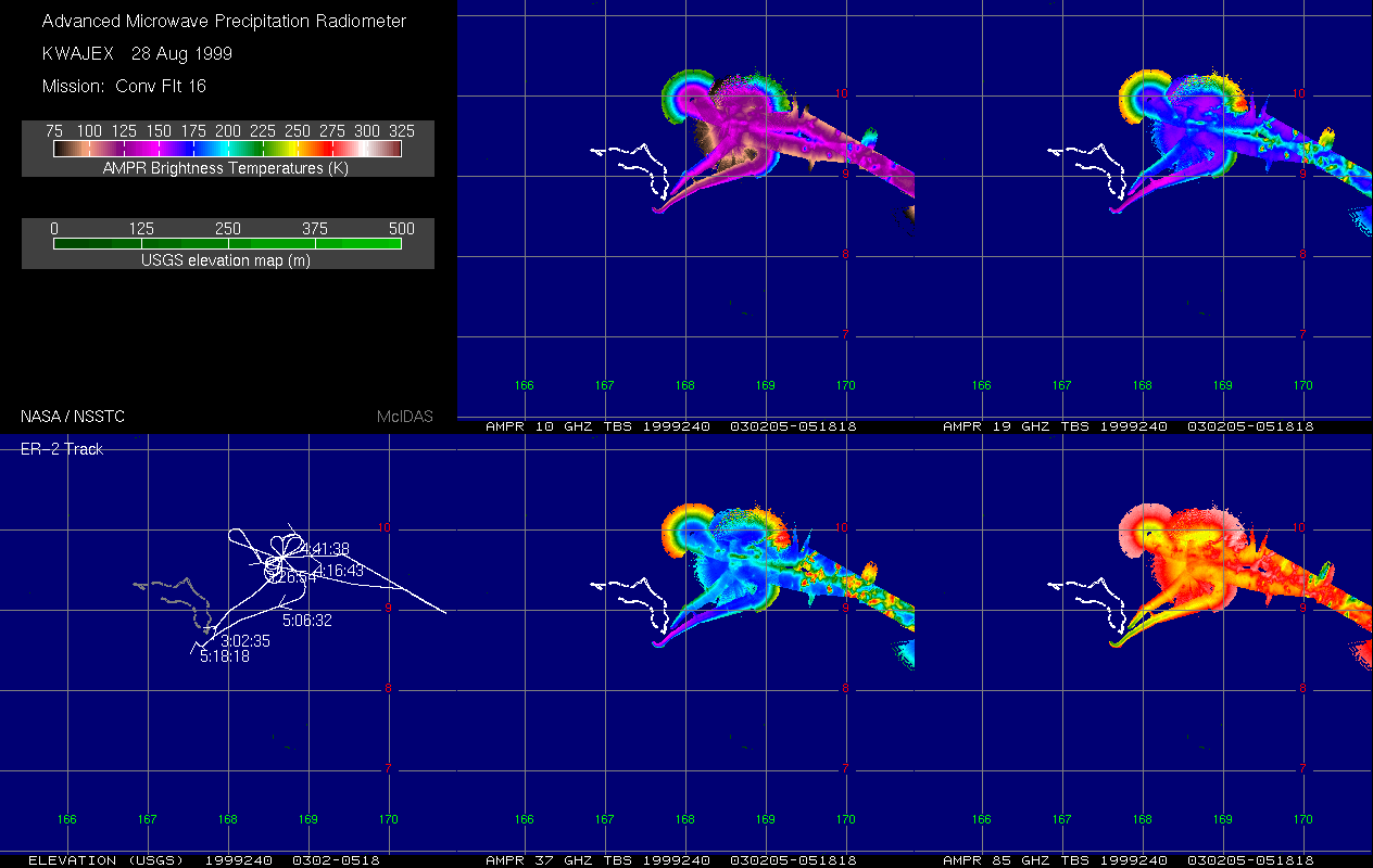
AMPR BRIGHTNESS TEMPERATURE (TB) KWAJEX V1
National Aeronautics and Space Administration —
The Advanced Microwave Precipitation Radiometer (AMPR) was deployed during the First Kwajelein Experiment (KWAJEX), which provided Ground Validation for instruments... -
Federal
AI4MARS: A Dataset for Terrain-Aware Autonomous Driving on Mars
National Aeronautics and Space Administration —
This dataset was built for training and validating terrain classification models for Mars, which may be useful in future autonomous rover efforts. It consists of... -
Federal
Saildrone Baja field campaign surface and ADCP measurements
National Aeronautics and Space Administration —
Saildrone is a wind and solar powered unmanned surface vehicle (USV) capable of long distance deployments lasting up to 12 months and providing high quality, near... -
Federal
VG2 NEP PLS DERIVED RDR 2 PROTON MAGSPHERE 48SEC V1.0
National Aeronautics and Space Administration —
This data set gives the best available values for ion densities, temperatures, and velocities near Neptune derived from data obtained by the Voyager 2 plasma... -
Federal
Regridded Harmonized World Soil Database v1.2
National Aeronautics and Space Administration —
This data set describes select global soil parameters from the Harmonized World Soil Database (HWSD) v1.2, including additional calculated parameters such as area... -
Federal
NACP Site: Terrestrial Biosphere Model and Aggregated Flux Data in Standard Format
National Aeronautics and Space Administration —
This data set provides standardized output variables for gross primary productivity (GPP), net ecosystem exchange (NEE), leaf area index (LAI), ecosystem respiration... -
Federal
Sentinel-5P TROPOMI Tropospheric Formaldehyde HCHO 1-Orbit L2 7km x 3.5km V1 (S5P_L2__HCHO__) at GES DISC
National Aeronautics and Space Administration —
Starting from August 6th in 2019, Sentinel-5P TROPOMI along-track high spatial resolution (~5.5km at nadir) has been implemented. Starting from July 13th in 2020,... -
Federal
TC4 AMPR BRIGHTNESS TEMPERATURE (TB) V1
National Aeronautics and Space Administration —
The TC4 AMPR Brightness Temperature (TB) dataset consists of brightness temperature data from July 19, 2007 through August 8, 2007. The Tropical Composition, Cloud... -
Federal
A Survey of Artificial Intelligence for Prognostics
National Aeronautics and Space Administration —
Integrated Systems Health Management includes as key elements fault detection, fault diagnostics, and failure prognostics. Whereas fault detection and diagnostics... -
Federal
GPM IMERG Late Precipitation L3 1 day 0.1 degree x 0.1 degree V07 (GPM_3IMERGDL) at GES DISC
National Aeronautics and Space Administration —
Version 07 is the current version of the data set. Older versions will no longer be available and have been superseded by Version 07.The Integrated Multi-satellitE... -
Federal
Gazetteer of Planetary Nomenclature: Saturnian System: Phoebe
National Aeronautics and Space Administration —
These images display several of Saturn's moons approved by the International Astronomical Union (IAU). -
Federal
GEDI L4A Footprint Level Aboveground Biomass Density, Version 1
National Aeronautics and Space Administration —
This dataset contains Global Ecosystem Dynamics Investigation (GEDI) Level 4A (L4A) predictions of the aboveground biomass density (AGBD; in Mg/ha) and estimates of... -
Federal
LOFAR 3C295 Field 62-MHz Source Catalog
National Aeronautics and Space Administration —
This table contains the source list from Low Frequency Array (LOFAR) Low Band observations of the 3C 295 field at 62 MHz. The images of this field and the Bootes... -
Federal
NASA 3D Models: IBEX
National Aeronautics and Space Administration —
Polygons: 4744 Vertices: 5258 -
Federal
ASTEROID PHOTOMETRIC CATALOG V1.1
National Aeronautics and Space Administration —
The Asteroid Photometric Catalog (3rd update), Lagerkvist, et.al., 1993 [LAGERKVISTETAL1993], is a compilation of all asteroid lightcurve photometry published up to... -
Federal
NEW HORIZONS MVIC PLUTO CRUISE RAW V1.0
National Aeronautics and Space Administration —
This data set contains Raw data taken by the New Horizons Multispectral Visible Imaging Camera instrument during the pluto cruise mission phase. This is VERSION 1.0...

Official websites use .gov
A
.gov website belongs to an official government
organization in the United States.
Secure .gov websites use HTTPS
A
lock (
) or https:// means you’ve safely connected to
the .gov website. Share sensitive information only on official,
secure websites.