
-
Federal
SAFARI 2000 CV-580 Aerosol and Cloud Data, Dry Season 2000 (CARG)
National Aeronautics and Space Administration —
The Cloud and Aerosol Research Group (CARG) of the University of Washington participated in the SAFARI-2000 Dry Season Aircraft campaign with their Convair-580... -
Federal
Sentinel-5P TROPOMI Radiance product band 1 (UV detector) L1B 5.5km x 21km V2 (S5P_L1B_RA_BD1_HiR) at GES DISC
National Aeronautics and Space Administration —
Starting from August 6th in 2019, Sentinel-5P TROPOMI along-track high spatial resolution (~5.5km at nadir) has been implemented. For data before August 6th of 2019,... -
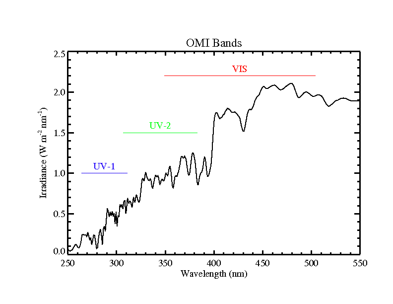
Federal
OMI/Aura Level 1B UV Global Geolocated Earthshine Radiances 1-orbit L2 Swath 13x24 km V003 (OML1BRUG) at GES DISC
National Aeronautics and Space Administration —
The Aura Ozone Monitoring Instrument (OMI) Level-1B (L1B) Geo-located Earth View UV Radiance, Global-Mode (OML1BRUG) Version-3 product contains geo-located Earth view... -
Federal
AirMSPI version 5 terrain-projected georegistered radiance product acquired during the NASA PODEX flight campaign Jan-Feb 2013
National Aeronautics and Space Administration —
AirMSPI_PODEX_Terrain-projected_Georegistered_Radiance_Data are AirMSPI terrain-projected georegistered radiance product acquired during the NASA Polarimeter... -
Federal
AirMSPI version 5 ellipsoid-projected georegistered radiance product acquired during the NASA PODEX flight campaign January-February 2013
National Aeronautics and Space Administration —
AirMSPI_PODEX_Ellipsoid-projected_Georegistered_Radiance_Data are AirMSPI Ellipsoid-projected georegistered radiance product acquired during the NASA Polarimeter... -
Federal
AirMSPI verison 6 terrain-projected georegistered radiance product acquired during the SPEX-PR flight campaign
National Aeronautics and Space Administration —
AirMSPI_SPEX-PR_Terrain-projected_Georegistered_Radiance_Data is an AirMSPI terrain-projected georegistered radiance product acquired during the SPEX engineering... -
Federal
AirMSPI verison 6 ellipsoid-projected georegistered radiance product acquired during the NASA ORACLES flight campaign Jul-Oct 2016
National Aeronautics and Space Administration —
AirMSPI_ORACLES_Ellipsoid-projected_Georegistered_Radiance_Data are AirMSPI Ellipsoid-projected georegistered radiance product acquired during the NASA ObseRvations... -
Federal
OMPS/NPP L1B NM Radiance EV Calibrated Geolocated Swath Orbital V2 (OMPS_NPP_NMEV_L1B) at GES DISC
National Aeronautics and Space Administration —
The OMPS-NPP L1B NM Radiance EV Calibrated Geolocated Swath Orbital collection contains calibrated and geolocated radiances from 300 to 380 nm measured by the OMPS... -
Federal
MODIS/Terra L0 PDS Data 5-Min Swath - NRT NGDA
National Aeronautics and Space Administration —
MODIS/Terra Near Real Time(NRT) L0 PDS Data 5-Min Swath. -
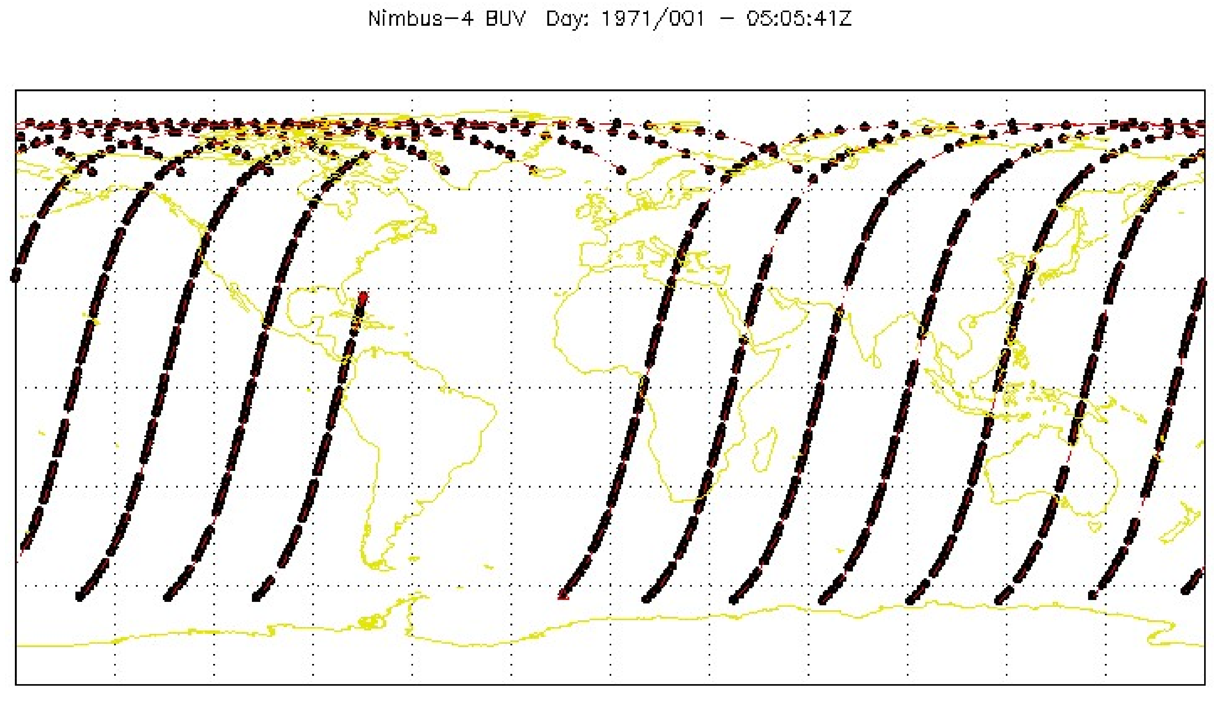
Federal
BUV/Nimbus-4 Dark Current Study Working Data V001 (BUVN4L1DCW) at GES DISC
National Aeronautics and Space Administration —
The Nimbus-4 BUV Level-1 Dark Current Study Working Data is derived from the BUV Level 1 Radiance (RUT) product and contains the geophysical indices and... -
Federal
G-LiHT Hyperspectral Radiance V001
National Aeronautics and Space Administration —
Goddard’s LiDAR, Hyperspectral, and Thermal Imager (G-LiHT) mission is a portable, airborne imaging system that aims to simultaneously map the composition, structure,... -
Federal
G-LiHT Metrics V001
National Aeronautics and Space Administration —
Goddard’s LiDAR, Hyperspectral, and Thermal Imager (G-LiHT) mission is a portable, airborne imaging system that aims to simultaneously map the composition, structure,... -
Federal
G-LiHT Hyperspectral Vegetative Indices V001
National Aeronautics and Space Administration —
Goddard’s LiDAR, Hyperspectral, and Thermal Imager (G-LiHT) mission is a portable, airborne imaging system that aims to simultaneously map the composition, structure,... -
Federal
EMIT L1B At-Sensor Calibrated Radiance and Geolocation Data 60 m V001
National Aeronautics and Space Administration —
The Earth Surface Mineral Dust Source Investigation (EMIT) instrument measures surface mineralogy, targeting the Earth’s arid dust source regions. EMIT is installed... -
Federal
Sentinel-5P TROPOMI Radiance product band 5 (NIR detector) L1B 5.5km x 3.5km V1 (S5P_L1B_RA_BD5_HiR) at GES DISC
National Aeronautics and Space Administration —
Starting from August 6th in 2019, Sentinel-5P TROPOMI along-track high spatial resolution (~5.5km at nadir) has been implemented. For data before August 6th of 2019,... -
Federal
Reduced Resolution Geolocated and Calibrated TOA Radiance
National Aeronautics and Space Administration —
The Medium Resolution Imaging Spectrometer (MERIS) is one of 10 sensors deployed in March of 2002 on board the polar-orbiting Envisat-1 environmental research... -
Federal
OMI/Aura Level 1B UV Zoom-in Geolocated Earthshine Radiances V004 (OML1BRUZ) at GES DISC
National Aeronautics and Space Administration —
The Aura Ozone Monitoring Instrument (OMI) Level 1B (L1B) Geolocated Earthshine UV Radiance, Zoom-mode (shortname OML1BRUZ) Version 4 product contains geolocated... -
Federal
MODIS/Terra Clear Radiance Statistics Indexed to Global Grid 5-Min L2 Swath 10km NGDA
National Aeronautics and Space Administration —
The MODIS/Terra Clear Radiance Statistics Indexed to Global Grid 5-Min L2 Swath 10km (MODCSR_G) product provides a variety of statistical measures that characterize... -
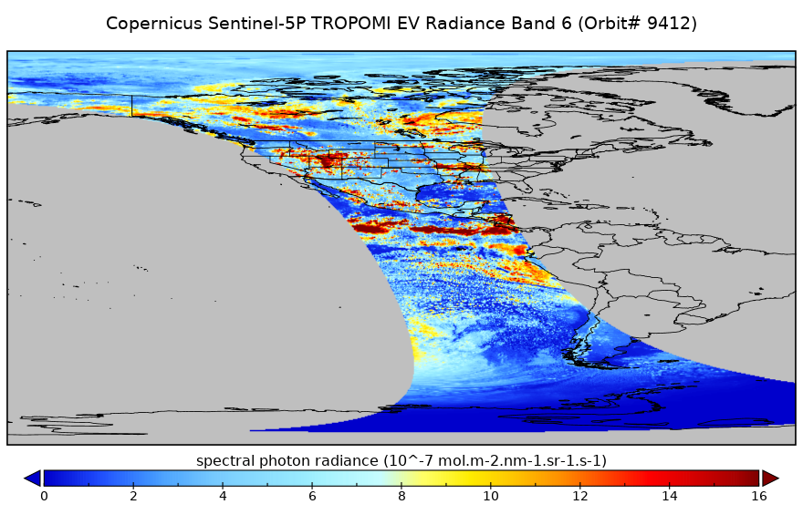
Federal
Sentinel-5P TROPOMI Radiance product band 6 (NIR detector) L1B 5.5km x 3.5km V2 (S5P_L1B_RA_BD6_HiR) at GES DISC
National Aeronautics and Space Administration —
Starting from August 6th in 2019, Sentinel-5P TROPOMI along-track high spatial resolution (~5.5km at nadir) has been implemented. For data before August 6th of 2019,... -
Federal
AirMSPI terrain-projected georegistered radiance product acquired during the NASA SEAC4RS flight campaign August-September 2013, V005
National Aeronautics and Space Administration —
AirMSPI_SEAC4RS_Terrain-projected_Georegistered_Radiance_Data are AirMSPI terrain-projected georegistered radiance product acquired during the NASA SEAC4RS flight...

Official websites use .gov
A
.gov website belongs to an official government
organization in the United States.
Secure .gov websites use HTTPS
A
lock (
) or https:// means you’ve safely connected to
the .gov website. Share sensitive information only on official,
secure websites.