
-
Federal
MODIS/Terra+Aqua L3 Value-added Aerosol Optical Depth - NRT NGDA
National Aeronautics and Space Administration —
MODIS was launched aboard the Terra satellite on December 18, 1999 (10:30 am equator crossing time) as part of NASA's Earth Observing System (EOS) mission. MODIS with... -
Federal
TEMPO gridded ozone total column (UNVALIDATED)
National Aeronautics and Space Administration —
Total ozone Level 3 files provide ozone information on a regular grid covering the TEMPO field of regard for nominal TEMPO observations. Level 3 files are derived by... -
Federal
MODIS/Terra Cloud Mask and Spectral Test Results 5-Min L2 Swath 250m and 1km - NRT NGDA
National Aeronautics and Space Administration —
The MODIS level-2 cloud mask product is a global product generated for both daytime and nighttime conditions at 1-km spatial resolution (at nadir) and for daytime at... -
Federal
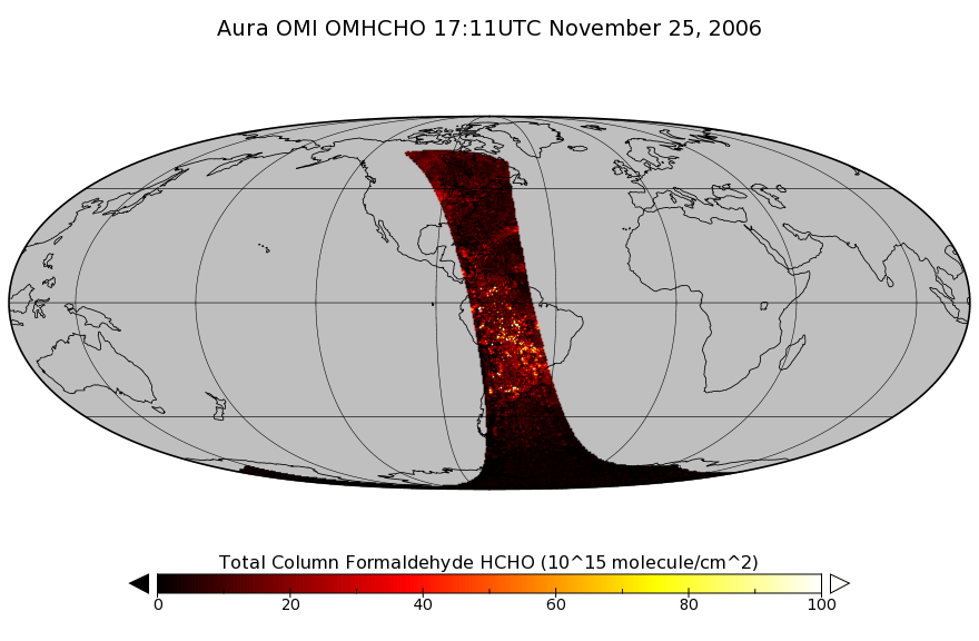
OMI/Aura Formaldehyde (HCHO) Total Column 1-orbit L2 Swath 13x24 km V003 (OMHCHO) at GES DISC
National Aeronautics and Space Administration —
The Aura Ozone Monitoring Instrument (OMI) Version-3 Formaldehyde Product OMHCHO is now available from the NASA Goddard Earth Sciences Data and Information Services... -
Federal
TROPESS CrIS-SNPP L2 Peroxyacetyl Nitrate for West Coast Fires, Standard Product V1 (TRPSDL2PANCRSWCF) at GES DISC
National Aeronautics and Space Administration —
The TROPESS CrIS-SNPP L2 Peroxyacetyl Nitrate for West Coast Fires, Standard Product contains the vertical distribution of the retrieved atmospheric state of... -
Federal
MISR L2 TOA/Cloud Stereo Product subset for the INTEX-B region V002
National Aeronautics and Space Administration —
MISR Level 2 TOA/Cloud Stereo Product containing the Stereoscopically Derived Cloud Mask (SDCM), cloud winds, Reflecting Level Reference Altitude (RLRA), with... -
Federal
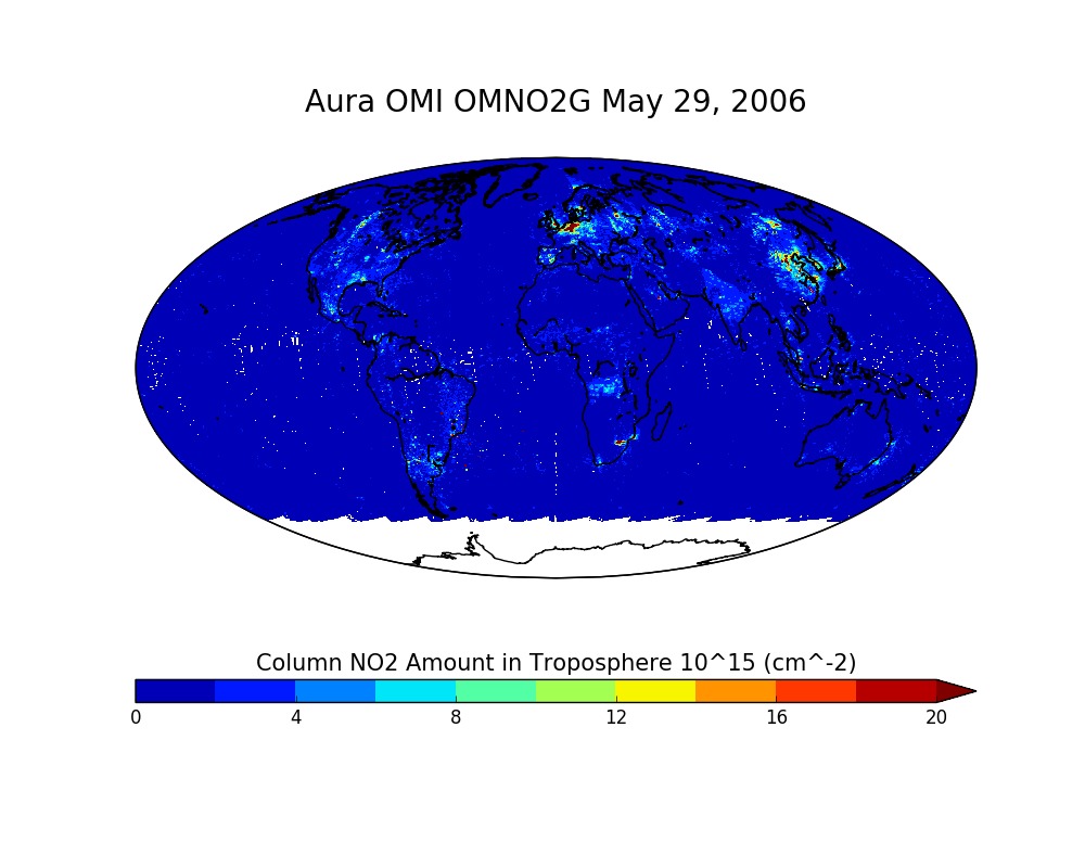
OMI/Aura NO2 Total and Tropospheric Column Daily L2 Global Gridded 0.25 degree x 0.25 degree V3 (OMNO2G) at GES DISC
National Aeronautics and Space Administration —
This Level-2G daily global gridded product OMNO2G is based on the pixel level OMI Level-2 NO2 product OMNO2. OMNO2G data product is a special Level-2 Gridded Product... -
Federal
MISR Level 2 Aerosol parameters V002
National Aeronautics and Space Administration —
Multi-angle Imaging SpectroRadiometer (MISR) is an instrument designed to view Earth with cameras pointed in 9 different directions. As the instrument flies overhead,... -
Federal
Global Change Master Directory (GCMD)
National Aeronautics and Space Administration —
The GCMD database holds more than 30,000 descriptions of Earth science data sets and services covering all aspects of Earth and environmental sciences. The mission of... -
Federal
GPM IMERG Early Precipitation L3 1 day 0.1 degree x 0.1 degree V07 (GPM_3IMERGDE) at GES DISC
National Aeronautics and Space Administration —
Version 07 is the current version of the data set. Older versions will no longer be available and have been superseded by Version 07. The Integrated Multi-satellitE... -
Federal
OCO-3 Level 2 geolocated XCO2 retrievals results, physical model, Retrospective Processing V10r (OCO3_L2_Standard) at GES DISC
National Aeronautics and Space Administration —
Version 10r is the current version of the data set. Older versions will no longer be available and are superseded by Version 10r. The Orbiting Carbon Observatory -3... -
Federal
CALIPSO Lidar Level 2 Aerosol Profile, V4-20
National Aeronautics and Space Administration —
CAL_LID_L2_05kmAPro-Standard-V4-20 is the Cloud-Aerosol Lidar and Infrared Pathfinder Satellite Observations (CALIPSO) Lidar Level 2 Aerosol Profile, Version 4-20... -
Federal
MERRA-2 tavg3_3d_rad_Np: 3d,3-Hourly,Time-Averaged,Pressure-Level,Assimilation,Radiation Diagnostics 0.625 x 0.5 degree V5.12.4 (M2T3NPRAD) at GES DISC
National Aeronautics and Space Administration —
M2T3NPRAD (or tavg3_3d_rad_Np) is a 3-dimensional 3-hourly time averaged data collection in Modern-Era Retrospective analysis for Research and Applications version 2... -
Federal
CALIPSO Lidar Level 3 Tropospheric Aerosol Profiles, Cloud Free Data, Standard V4-20
National Aeronautics and Space Administration —
CAL_LID_L3_Tropospheric_APro_CloudFree-Standard-V4-20 is the Cloud-Aerosol Lidar and Infrared Pathfinder Satellite Observation (CALIPSO) Lidar Level 3 Tropospheric... -
Federal
SCATSAT-1 ESDR Level 2 Modeled Ocean Surface Auxiliary Fields Version 1.0
National Aeronautics and Space Administration —
This dataset contains the first provisional release of the MEaSUREs-funded Earth Science Data Record (ESDR) of ancillary data corresponding to the SCATSAT-1 Level 2... -
Federal
GLDAS Catchment Land Surface Model L4 daily 0.25 x 0.25 degree V2.0 (GLDAS_CLSM025_D) at GES DISC
National Aeronautics and Space Administration —
NASA Global Land Data Assimilation System Version 2 (GLDAS-2) has three components: GLDAS-2.0, GLDAS-2.1, and GLDAS-2.2. GLDAS-2.0 is forced entirely with the... -
Federal
Daily and Annual PM2.5, O3, and NO2 Concentrations at ZIP Codes for the Contiguous U.S., 2000-2016, v1.0
National Aeronautics and Space Administration —
The Daily and Annual PM2.5, O3, and NO2 Concentrations at ZIP Codes for the Contiguous U.S., 2000-2016, v1.0 data set contains daily and annual concentration... -
Federal
CLPX-Model: Land Data Assimilation System (LDAS) Data, Version 1
National Aeronautics and Space Administration —
The LDAS data set contains 43 model and observation-based fields produced by the LDAS uncoupled modeling system at the NASA Goddard Space Flight Center using the... -
Federal
TES/Aura L2 Ammonia Nadir Special Observation V007
National Aeronautics and Space Administration —
TL2NH3NS_7 is the Tropospheric Emission Spectrometer (TES)/Aura Level 2 Ammonia Nadir Special Observation Version 7 data product. TES was an instrument aboard NASA's... -
Federal
GEWEX SRB Integrated Product (Rel-4) Longwave Monthly Average by UTC Ocean-only Fluxes
National Aeronautics and Space Administration —
GEWEXSRB_Rel4-IP_Longwave_monthly_oceanonly_utc is the Global Energy and Water Exchanges (GEWEX) Surface Radiation Budget (SRB) Integrated Product (Rel-4) Longwave...

Official websites use .gov
A
.gov website belongs to an official government
organization in the United States.
Secure .gov websites use HTTPS
A
lock (
) or https:// means you’ve safely connected to
the .gov website. Share sensitive information only on official,
secure websites.