
-
Federal
Delta-X: NUMAR Predictive Model for Marsh Accretion Rates and Chemical Properties
National Aeronautics and Space Administration —
This dataset provides input data and model code to run the Marsh Accretion Rates (NUMAR) process model used to predict soil accretion rates and chemical properties... -
Federal
ARC Code TI: ROBUS-2
National Aeronautics and Space Administration —
The ROBUS-2 Protocol Processor (RPP) is a custom-designed hardware component implementing the functionality of the ROBUS-2 fault-tolerant communication system. The... -
Federal
Tropical CPR identification data for Organization Metric
National Aeronautics and Space Administration —
There are three kinds of files are in one zip file. 1) Cloud-Precipitation (hybrid) regime information projected onto hourly IMERG precipitation data (Version Pr6x7... -
Federal
AERONET-OCEAN COLOR
National Aeronautics and Space Administration —
The Aerosol Robotic Network (AERONET), developed to sustain atmospheric studies at various scales with measurements from worldwide distributed autonomous sun-... -
Federal
ARC Code TI: X-Plane Communications Toolbox (XPC)
National Aeronautics and Space Administration —
The X-Plane Communications Toolbox (XPC) is an open source research tool used to interact with the commercial flight simulator software X-Plane. XPC allows users to... -
Federal
ARC Code TI: Multi-Fidelity Simulator (MFSim)
National Aeronautics and Space Administration —
Multi-Fidelity Simulator, MFSim is a pluggable framework for creating an air traffic flow simulator at multiple levels of fidelity. The framework is designed to allow... -
Federal
Daily and Annual PM2.5, O3, and NO2 Concentrations at ZIP Codes for the Contiguous U.S., 2000-2016, v1.0
National Aeronautics and Space Administration —
The Daily and Annual PM2.5, O3, and NO2 Concentrations at ZIP Codes for the Contiguous U.S., 2000-2016, v1.0 data set contains daily and annual concentration... -
Federal
NLCD 1992/2001 Retrofit Land Cover Change Product
National Aeronautics and Space Administration —
Developments in mapping methodology, new sources of input data, and changes in the mapping legend for the 2001 National Land Cover Database (NLCD2001) will confound... -
Federal
Tropical Cloud-Precip (hybrid) Regime, Pr6x1 set
National Aeronautics and Space Administration —
Cloud-Precipitation Hybrid Regimes with MODIS C6.1 2D joint histogram of CTP and COT (total 42 bins) and IMERG v06B precipitation histogram (total 6 bins) derived in... -
Federal
AERONET-OCEAN COLOR
National Aeronautics and Space Administration —
The Aerosol Robotic Network (AERONET), developed to sustain atmospheric studies at various scales with measurements from worldwide distributed autonomous sun-... -
Federal
nu-Anomica algorithm
National Aeronautics and Space Administration —
One-class nu-Support Vector machine (SVMs) learning technique maps the input data into a much higher dimensional space and then uses a small portion of the training... -
Federal
ARC Code TI: E-Standards for Mass Properties Engineering
National Aeronautics and Space Administration —
The purpose of this Opensource forum is to promote the development of a JAVA based Application Programming Interface for the field of Mass Properties Engineering. -
Federal
Cloud Regime for CRE Feedback Study
National Aeronautics and Space Administration —
Cloud-only regimes (and 3 sub-regimes of CR15) originally derived from Terra and Aqua observations in 50S-50N, and corresponding "regime numbers on map" files... -
Federal
Lund-Potsdam-Jena Wetland Hydrology and Methane DGV Model (LPJ-WHyMe v1.3.1)
National Aeronautics and Space Administration —
This model product provides the Fortran 77 source code for the Lund-Potsdam-Jena (LPJ) Wetland Hydrology and Methane Dynamic Global Vegetation Model (LPJ-WHyMe... -
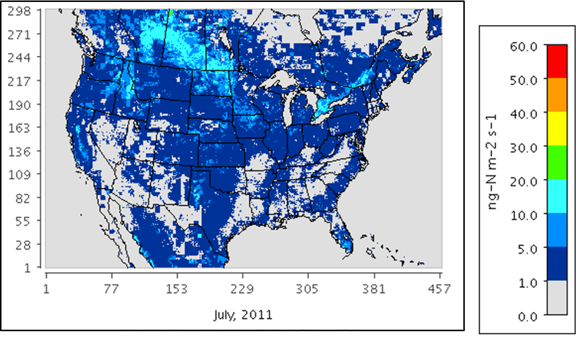
Federal
Mechanistic Module for Soil Nitrogen Emissions for CMAQ Model, North America, 2011
National Aeronautics and Space Administration —
This model product provides source code, input data files, and example model outputs for a new mechanistic soil nitrogen (N) module in-line with the Community... -
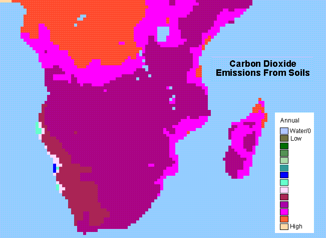
Federal
SAFARI 2000 Monthly and Annual CO2 Emissions from Soil, 0.5 Degree Grid
National Aeronautics and Space Administration —
The data set provides estimated monthly and annual soil CO2 emissions for southern Africa (the SAFARI 2000 project region). The calculated emissions are from the... -
Federal
SAFARI 2000 MODIS MOD05_L2 Water Vapor Data, Binary Format, for Southern Africa
National Aeronautics and Space Administration —
The Moderate Resolution Imaging Spectroradiometer (MODIS) precipitable water product consists of vertical column water-vapor amounts in centimeters (cm) at 1-km... -
Federal
Wetland Salinity Maps of Select Estuary Sites in the United States, 2020
National Aeronautics and Space Administration —
This dataset provides gridded average annual wetland salinity concentrations in practical salinity units (PSU) at 30-meter resolution within 24 coastal estuary sites... -
Federal
SHIFT: Wetland Spectra, Salinity, and Fractional Cover, Devereux Slough, CA, 2022
National Aeronautics and Space Administration —
This dataset includes field data, analysis code, and corresponding airborne imagery collected and generated during the 2022 NASA Surface Biology Geology (SBG) High...

Official websites use .gov
A
.gov website belongs to an official government
organization in the United States.
Secure .gov websites use HTTPS
A
lock (
) or https:// means you’ve safely connected to
the .gov website. Share sensitive information only on official,
secure websites.