
-
Federal
USGS Global Forest Observations Initiative (GFOI) Guatemala
National Aeronautics and Space Administration —
The Global Forest Observations Initiative (GFOI) is an initiative of the inter-governmental Group on Earth Observations (GEO) that aims to: foster the sustained... -
Federal
USGS Global Forest Observations Initiative (GFOI) Thailand
National Aeronautics and Space Administration —
The Global Forest Observations Initiative (GFOI) is an initiative of the inter-governmental Group on Earth Observations (GEO) that aims to: foster the sustained... -
Federal
CALIPSO Lidar Level 2 Vertical Feature Mask (VFM), V4-20
National Aeronautics and Space Administration —
CAL_LID_L2_VFM-Standard-V4-20 is the Cloud-Aerosol Lidar and Infrared Pathfinder Satellite Observations (CALIPSO) Lidar Level 2 Vertical Feature Mask (VFM), Version... -
Federal
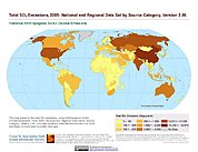
Anthropogenic Sulfur Dioxide Emissions, 1850-2005: National and Regional Data Set by Source Category, Version 2.86
National Aeronautics and Space Administration —
The Anthropogenic Sulfur Dioxide Emissions, 1850-2005: National and Regional Data Set by Source Category, Version 2.86 provides annual estimates of anthropogenic... -
Federal
SCOAPE-II R/V Point Sur Data
National Aeronautics and Space Administration —
SCOAPE2_RVPointSur_Data is the data collected from instruments onboard the University of Southern Mississippi’s Research Vessel (R/V) Point Sur during the Satellite... -
Federal
USGS Global Forest Observations Initiative (GFOI) Vietnam
National Aeronautics and Space Administration —
The Global Forest Observations Initiative (GFOI) is an initiative of the inter-governmental Group on Earth Observations (GEO) that aims to: foster the sustained... -
Federal
Forest Carbon Stocks and Fluxes from the NFCMS, Conterminous USA, 1990-2010
National Aeronautics and Space Administration —
This dataset, derived from the National Forest Carbon Monitoring System (NFCMS), provides estimates of forest carbon stocks and fluxes in the form of aboveground... -
Federal
CALIPSO Lidar Level 1.5 Profile, V1-00
National Aeronautics and Space Administration —
CAL_LID_L15-Standard-V1-00 is the Cloud-Aerosol Lidar and Infrared Pathfinder Satellite Observations (CALIPSO) Lidar Level 1.5 Profile, Version 1-00 data product.... -
Federal
NASA Enterprise Data Inventory (EDI)
National Aeronautics and Space Administration —
EDI Redaction letter -
Federal
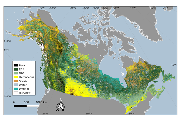
ABoVE: Landsat-derived Annual Dominant Land Cover in Boreal North America, 1986-2020
National Aeronautics and Space Administration —
This dataset contains a 30-m resolution time series of annual land cover classifications as the dominant plant functional type class for all of boreal Alaska and... -
Federal
CALIPSO Lidar Level 2 1 km Cloud Layer, V4-20
National Aeronautics and Space Administration —
CAL_LID_L2_01kmCLay-Standard-V4-20 is the Cloud-Aerosol Lidar and Infrared Pathfinder Satellite Observations (CALIPSO) Lidar Level 2 1 km Cloud Layer, Version 4-20... -
Federal
Description, Classification and Inventory of Apollo 17 Rake Samples from Station 6
National Aeronautics and Space Administration —
Description, Classification and Inventory of Apollo 17 Rake Samples from Station 6; W.C. Phinney, C. Simonds, and J. Warner -
Federal
National Land Cover Database 2006 (NLCD2006)
National Aeronautics and Space Administration —
National Land Cover Database 2006 (NLCD2006) is a 16-class land cover classification scheme that has been applied consistently across the conterminous United States... -
Federal
CALIPSO Lidar Level 2 5 km Cloud Layer, V4-20
National Aeronautics and Space Administration —
CAL_LID_L2_05kmCLay-Standard-V4-20 is the Cloud-Aerosol Lidar and Infrared Pathfinder Satellite Observations (CALIPSO) Lidar Level 2 5 km Cloud Layer, Version 4-20... -
Federal
Coordinated Data Analysis System (CDAWeb CDAS) RESTful Web services API at the Space Physics Data Facility (SPDF)
National Aeronautics and Space Administration —
A RESTful web service for querying data and metadata components from data sets, including instruments, observatories, and inventory. This interface calls the services... -
Federal
USGS Global Forest Observations Initiative (GFOI) Cambodia
National Aeronautics and Space Administration —
The Global Forest Observations Initiative (GFOI) is an initiative of the inter-governmental Group on Earth Observations (GEO) that aims to: foster the sustained... -
Federal
USGS Global Forest Observations Initiative (GFOI) Guyana
National Aeronautics and Space Administration —
The Global Forest Observations Initiative (GFOI) is an initiative of the inter-governmental Group on Earth Observations (GEO) that aims to: foster the sustained... -
Federal
VISSR/SMS-1 Level 1 Atmospheric and Oceanographic Image Processing System (AOIPS) Data V001 (VISSRSMS1L1AOIPS) at GES DISC
National Aeronautics and Space Administration —
VISSRSMS1L1AOIPS is the Visible Infrared Spin-Scan Radiometer (VISSR) Level 1 Atmospheric and Oceanographic Image Processing System (AOIPS) data product from the... -
Federal
Apollo 15 Coarse Fines (4-10 mm): Sample Classification, Description, and Inventory
National Aeronautics and Space Administration —
Apollo 15 Coarse Fines (4-10 mm): Sample Classification, Description, and Inventory; MSC 03228; B. Powell

Official websites use .gov
A
.gov website belongs to an official government
organization in the United States.
Secure .gov websites use HTTPS
A
lock (
) or https:// means you’ve safely connected to
the .gov website. Share sensitive information only on official,
secure websites.