
-
Federal
BOREAS AFM-06 Boundary Layer Height Data
National Aeronautics and Space Administration —
The BOREAS AFM-06 team from the National Oceanic and Atmospheric Administration Environment Technology Laboratory (NOAA/ETL) operated a 915 MHz wind/Radio Acoustic... -
Federal
Earth Radiation Budget Experiment (ERBE) S-4G Nonscanner,Wide Field of View (WFOV) Numerical Filter (NF) 5 and 10 degree Zonal and Global Averages in HDF
National Aeronautics and Space Administration —
ERBE_S4G_WFOV_NF_ZG_1 is the Earth Radiation Budget Experiment (ERBE) S-4G Non-scanner, Wide Field of View (WFOV) Numerical Filter (NF) 5 and 10 degree Zonal and... -
Federal
Gridded Population of the World, Version 3 (GPWv3): Subnational Administrative Boundaries
National Aeronautics and Space Administration —
The Gridded Population of the World, Version 3 (GPWv3): Subnational Administrative Boundaries are the basis of the population data products in GPWv3. Due to copyright... -
Federal
China Dimensions Data Collection: Bibliography of Chinese Administrative Geography
National Aeronautics and Space Administration —
The Bibliography of Chinese Administrative Geography is a historical collection of bibliographic information on 75 published books describing the administrative... -
Federal
UAVSAR_POLSAR_SLOPE
National Aeronautics and Space Administration —
UAVSAR PolSAR Scene Slope -
Federal
Turbulence Models: Shock Boundary Layer Interaction at M=2.05
National Aeronautics and Space Administration —
Exp: Shock Boundary Layer Interaction at M=2.05. This web page provides data from experiments that may be useful for the validation of turbulence models. This... -
Federal
UAVSAR_POLSAR_ML_COMPLEX_GRD
National Aeronautics and Space Administration —
UAVSAR PolSAR Scene Projected -
Federal
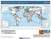
Gridded Population of the World, Version 3 (GPWv3): National Administrative Boundaries
National Aeronautics and Space Administration —
The Gridded Population of the World, Version 3 (GPWv3): National Administrative Boundaries are derived from the land area grid to show the outlines of pixels (cells)... -
Federal
Gridded Population of the World, Version 3 (GPWv3): Centroids
National Aeronautics and Space Administration —
The Gridded Population of the World, Version 3 (GPWv3): Centroids consists of estimates of human population counts and densities for the years 1990, 1995, 2000, 2005,... -
Federal
JPSS-2 CrIS IMG_COL: Array indices for collocated VIIRS observations V3.0 (SNDRJ2CrISL1BIMGC) at GES DISC
National Aeronautics and Space Administration —
The Cross-track Infrared Sounder (CrIS) Level 1B Full Spectral Resolution (FSR) data files contain radiance measurements along with ancillary spacecraft, instrument,... -
Federal
ACCLIP WB-57 Aircraft Model Data
National Aeronautics and Space Administration —
ACCLIP_Model_WB57_Data contains modeled meteorological, chemical, and aerosol data along the flight tracks of the WB-57 aircraft during the Asian Summer Monsoon... -
Federal
Turbulence Models: Shock Boundary Layer Interaction at M=2.05
National Aeronautics and Space Administration —
Exp: Shock Boundary Layer Interaction at M=2.05. This web page provides data from experiments that may be useful for the validation of turbulence models. This... -
Federal
UAVSAR_POLSAR_ML_COMPLEX_GRD_5X5
National Aeronautics and Space Administration —
UAVSAR PolSAR Scene Projected Multilook 5x5 -
Federal
Turbulence Models: Shock Boundary Layer Interaction at M=2.05
National Aeronautics and Space Administration —
Exp: Shock Boundary Layer Interaction at M=2.05. This web page provides data from experiments that may be useful for the validation of turbulence models. This... -
Federal
CPEX-AW Dropsonde Data
National Aeronautics and Space Administration —
CPEXAW-Dropsondes_1 is the dropsonde data files collected during the Convective Processes Experiment - Aerosols & Winds (CPEX-AW). Data collection for this... -
Federal
AIRSAR_TOPSAR_DEM_C
National Aeronautics and Space Administration —
AIRSAR topographic SAR digital elevation model CTIF product -
Federal
Global Rural-Urban Mapping Project, Version 1 (GRUMPv1): National Administrative Boundaries
National Aeronautics and Space Administration —
The Global Rural-Urban Mapping Project, Version 1 (GRUMPv1): National Administrative Boundaries are derived from the land area grid to show the outlines of pixels... -
Federal
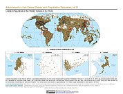
Gridded Population of the World, Version 4 (GPWv4): Administrative Unit Center Points with Population Estimates, Revision 11
National Aeronautics and Space Administration —
The Gridded Population of the World, Version 4 (GPWv4): Administrative Unit Center Points with Population Estimates, Revision 11 consists of UN WPP-adjusted... -
Federal
PISTON 2018-2019 Island Rawinsonde Data
National Aeronautics and Space Administration —
PISTON-ONR-NOAA_Islands_2018-2019 is the Propagation of Intra-Seasonal Tropical Oscillations (PISTON) 2018-2019 island rawinsonde data product. This product is the...

Official websites use .gov
A
.gov website belongs to an official government
organization in the United States.
Secure .gov websites use HTTPS
A
lock (
) or https:// means you’ve safely connected to
the .gov website. Share sensitive information only on official,
secure websites.