
-
Federal
MMS 2 Digital Signal Processor (DSP) Search Coil Magnetometer (SCM), Magnetic Field Power Spectral Density, Level 2 (L2), Slow Mode, 16 s Data
National Aeronautics and Space Administration —
The MMS magnetic field power spectral density (BPSD) is computed onboard by the Digital Signal Processor (DSP). The fast Fourier transform (FFT) calculation is... -
Federal
ISLSCP II Climate Research Unit CRU05 Monthly Climate Data
National Aeronautics and Space Administration —
This data set contains a mean monthly climatology for several climate variables averaged over the period from 1961 to 1990, and constructed from a data set of station... -
Federal
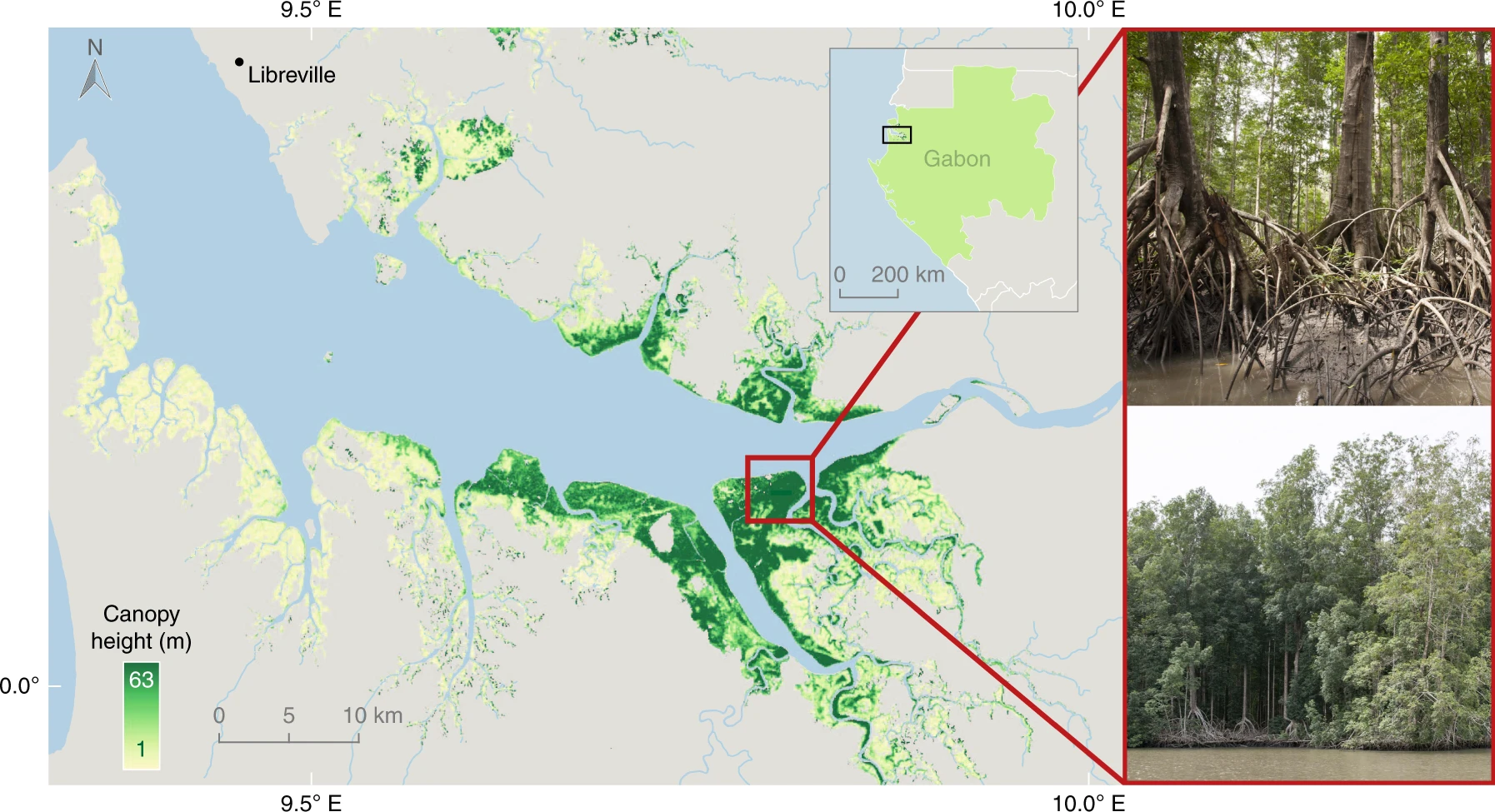
CMS: Global Mangrove Canopy Height Maps Derived from TanDEM-X, 2015
National Aeronautics and Space Administration —
This dataset characterizes canopy heights of mangrove-forested wetlands globally for 2015 at 12-m resolution. Estimates of maximum canopy height (height of the... -
Federal
PROVE Land Cover and Leaf Area of Jornada Experimental Range, New Mexico, 1997
National Aeronautics and Space Administration —
Field measurement of shrubland ecological properties is important for both site monitoring and validation of remote-sensing information. During the NASA Earth... -
Federal
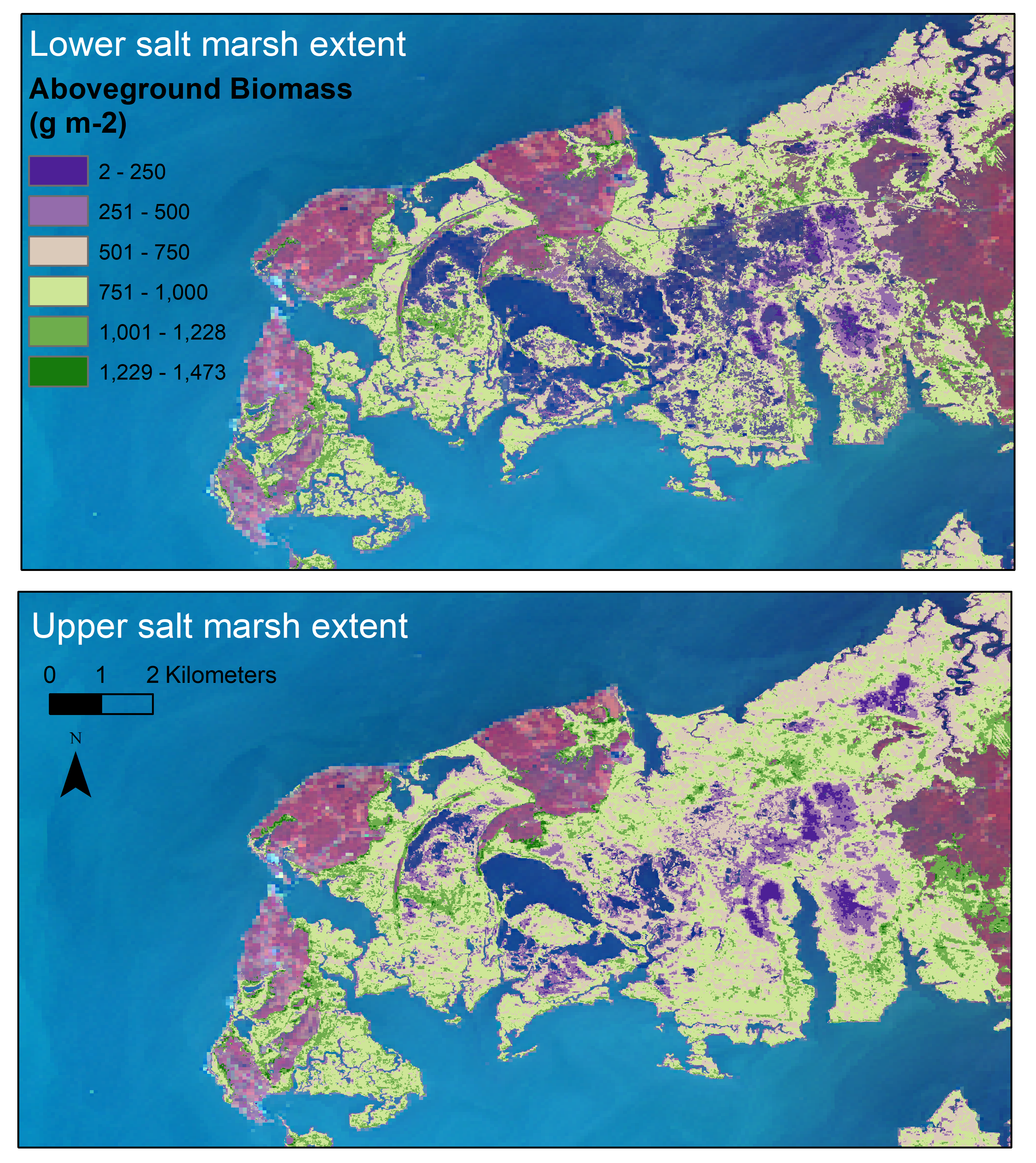
Aboveground Biomass Estimates for Salt Marsh for the Contiguous United States, 2020
National Aeronautics and Space Administration —
This dataset provides estimates of aboveground biomass (AGB) and salt marsh extent in the contiguous United States for 2020 and includes all coastal watersheds across... -
Federal
SORCE XPS Level 4 Solar Spectral Irradiance 0.1nm Res 5-Minute V012 (SOR4XPS5) at GES DISC
National Aeronautics and Space Administration —
The SORCE XPS Level 4 Solar Spectral Irradiance 0.1nm Res 5-Minute product (SOR4XPS5) contains modelled spectral extreme ultraviolet (XUV) irradiances based on... -
Federal
Digital Elevation Models for the Global Change Research Wetland, Maryland, USA, 2016
National Aeronautics and Space Administration —
This dataset contains four alternative digital elevation models (DEMs) at 1 m resolution and model performance statistical metrics for the Global Change Research... -
Federal
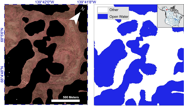
ABoVE: AirSWOT Water Masks from Color-Infrared Imagery over Alaska and Canada, 2017
National Aeronautics and Space Administration —
This dataset provides 1) a conservative open water mask for future water surface elevation (WSE) extraction from the co-registered AirSWOT Ka-band interferometry... -
Federal
MMS 3 Digital Signal Processor (DSP) Double Probe (ADP, SDP), Electric Field Power Spectral Density, Level 2 (L2), Slow Mode, 16 s Data
National Aeronautics and Space Administration —
The MMS electric field power spectral density (EPSD) is computed onboard by the Digital Signal Processor (DSP). The fast Fourier transform (FFT) calculation is... -
Federal
LBA-ECO LC-24 Cadastral Property Map of Uruara, Para, Brazil: ca.1975
National Aeronautics and Space Administration —
This data set contains a shapefile of a digitized map of the land parcel information of the original properties of the Uruara colonization site, Para, Brazil,... -
Federal
MMS 4 Digital Signal Processor (DSP) Search Coil Magnetometer (SCM), Magnetic Field Power Spectral Density, Level 2 (L2), Slow Mode, 16 s Data
National Aeronautics and Space Administration —
The MMS magnetic field power spectral density (BPSD) is computed onboard by the Digital Signal Processor (DSP). The fast Fourier transform (FFT) calculation is... -
Federal
MMS 3 Digital Signal Processor (DSP) Double Probe (ADP, SDP), Electric Field Power Spectral Density, Level 2 (L2), Fast Mode, 2 s Data
National Aeronautics and Space Administration —
The MMS electric field power spectral density (EPSD) is computed onboard by the Digital Signal Processor (DSP). The fast Fourier transform (FFT) calculation is... -
Federal
SORCE XPS Level 4 Solar Spectral Irradiance 0.1nm Res 24-Hour Means V012 (SOR4XPSD_HIGH) at GES DISC
National Aeronautics and Space Administration —
The SORCE XPS Level 4 Solar Spectral Irradiance 0.1nm Res 24-Hour Means product (SOR4XPSD_HIGH) contains modelled spectral extreme ultraviolet (XUV) irradiances based... -
Federal
LBA-ECO ND-11 Pre-harvest Forest Tree and Liana Biomass, NW Mato Grosso, Brazil: 2003
National Aeronautics and Space Administration —
The purpose of this study was to determine if spatially-explicit commercial timber inventories (CTI) could be used in conjunction with satellite imagery to improve... -
Federal
ISLSCP II CRU05 Climate Time Series for Global Land Areas, 1986-1995
National Aeronautics and Space Administration —
This data set contains monthly climate time series data created by the Climatic Research Unit (CRU) at the University of East Anglia, U.K., for every year covering... -
Federal
Walker Branch Watershed Vegetation Inventory, 1967-2006, R1
National Aeronautics and Space Administration —
This data set contains five data files, in comma-separated format (.csv), derived from the Walker Branch Watershed (WBW) vegetation inventory in eastern Tennessee....

Official websites use .gov
A
.gov website belongs to an official government
organization in the United States.
Secure .gov websites use HTTPS
A
lock (
) or https:// means you’ve safely connected to
the .gov website. Share sensitive information only on official,
secure websites.