
-
Federal
Wind SMS Suite SupraThermal Ion Composition Spectrometer (SMS/STICS) Ion Moments, Level 2 (L2), 3-minute Data in Solar Wind
National Aeronautics and Space Administration —
The data include Wind STICS 3-minute density (0th moment) and mean value of the energy distribution (1st moment), together with their statistical errors, for selected... -
Federal
Wind SMS Suite SupraThermal Ion Composition Spectrometer (SMS/STICS) Energy-Resolved Pitch-Angle Distributions (ERPAs), Level 2 (L2), 30-minute Data in Solar Wind
National Aeronautics and Space Administration —
The data include Wind STICS 30-minute Energy-Resolved Pitch-Angle Distributions (ERPAs) for selected ion species using triple coincidence (H+, He+, He2+, C5+, O+,... -
Federal
THEMIS-D: Search Coil Magnetometer 1/8s, 1/128s and 1/8192s Data
National Aeronautics and Space Administration —
THEMIS-D: Search Coil Magnetometer (SCM) magnetic field measurements. Includes FAST SURVEY, PARTICLE BURST and WAVE BURST data. FAST SURVEY (SCF): 1/8 second time... -
Federal
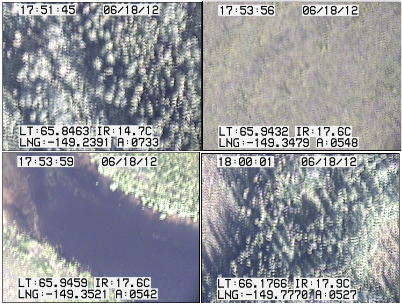
CARVE: In-flight Videos from the CARVE Aircraft, Alaska, 2012-2015
National Aeronautics and Space Administration —
This dataset contains videos captured by a camera mounted on the CARVE aircraft during airborne campaigns over the Alaskan and Canadian Arctic for the Carbon in... -
Federal
GPM MHS on NOAA19 (GPROF) Radiometer Precipitation Profiling L3 1 day 0.25 degree x 0.25 degree V07 (GPM_3GPROFNOAA19MHS_DAY) at GES DISC
National Aeronautics and Space Administration —
Version 07 is the current version of the data set. Older versions will no longer be available and have been superseded by Version 07. 3GPROF products provide global... -
Federal
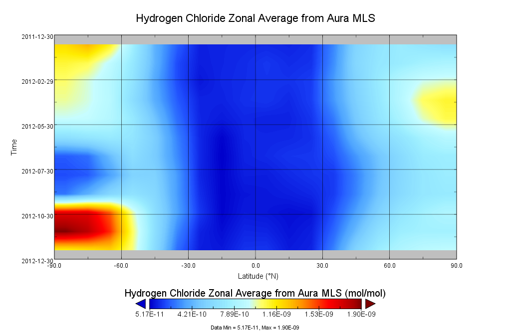
GOZCARDS Source Hydrogen Chloride 1 month L3 10 degree Zonal Means on a Vertical Pressure Grid V1 (GozSmlpHCl) at GES DISC
National Aeronautics and Space Administration —
The GOZCARDS Source Data for Hydrogen Chloride 1 month L3 10 degree Zonal Averages on a Vertical Pressure Grid product (GozSmlpHCl) contains zonal means and related... -
Federal
GPM GROUND VALIDATION ADVANCED MICROWAVE RADIOMETER RAIN IDENTIFICATION (ADMIRARI) GCPEX V1
National Aeronautics and Space Administration —
The GPM Ground Validation Advanced Microwave Radiometer Rain Identification (ADMIRARI) GCPEx dataset measures brightness temperature at three frequencies (10.7, 21.0... -
Federal
GHRSST Level 2P Global skin Sea Surface Temperature from the Infrared Atmospheric Sounding Interferometer (IASI) on the Metop-A satellite (GDS V2) produced by OSI SAF
National Aeronautics and Space Administration —
A global 1 km Group for High Resolution Sea Surface Temperature (GHRSST) Level 2P dataset based on multi-channel sea surface temperature (SST) retrievals generated in... -
Federal
CMS: LiDAR-derived Canopy Height, Elevation for Sites in Kalimantan, Indonesia, 2014
National Aeronautics and Space Administration —
This dataset provides canopy height and elevation data products derived from airborne LiDAR data collected over 90 sites on the island of Borneo in late 2014. The... -
Federal
CERES Regionally Averaged TOA Fluxes, Clouds and Aerosols Hourly NOAA-20 Edition 1C
National Aeronautics and Space Administration —
CER_SSF1deg-Hour_NOAA20-VIIRS_Edition1C is the NOAA-20 Clouds and the Earth's Radiant Energy System (CERES) Level 3 Single Scanner Footprint (SSF) Edition1C observed... -
Federal
CERES ERBE-like Gridded Instantaneous TOA Fluxes Terra and Aqua Cross-track Edition4
National Aeronautics and Space Administration —
CER_ES9_Terra+Aqua_Edition4 is the Clouds and the Earth's Radiant Energy System (CERES) Earth Radiation Budget Experiment (ERBE)-like Gridded Instantaneous Top-of-... -
Federal
CERES ERBE-like Monthly Regional Averages NOAA-20 FM6 Edition1
National Aeronautics and Space Administration —
CER_ES9_NOAA20-FM6_Edition1, CERES ERBE-like Monthly Regional Averages NOAA-20 FM6 Edition 1, contains TOA fluxes from the Clouds and the Earth's Radiant Energy... -
Federal
CERES ERBE-like Instantaneous TOA Estimates Terra FM2 Edition4
National Aeronautics and Space Administration —
CER_ES8_Terra-FM2_Edition4 is the Clouds and the Earth's Radiant Energy System (CERES) Earth Radiation Budget Experiment (ERBE)-like Instantaneous Top-of-the-... -
Federal
CERES Energy Balanced and Filled (EBAF) TOA Monthly means data in netCDF Edition4.1
National Aeronautics and Space Administration —
CERES_EBAF-TOA_Edition4.1 is the Clouds and the Earth's Radiant Energy System (CERES) Energy Balanced and Filled (EBAF) Top-of-Atmosphere (TOA) Monthly means data in... -
Federal
CERES Clouds and Radiative Swath TRMM Edition2C
National Aeronautics and Space Administration —
CER_CRS_TRMM-PFM-VIRS_Edition2C is the Clouds and the Earth's Radiant Energy System (CERES) Clouds and Radiative Swath (CRS) Tropical Rainfall Measuring Mission... -
Federal
BOREAS/AES Campbell Scientific 15-minute Surface Meteorological Data: 1995
National Aeronautics and Space Administration —
Canadian AES personnel collected data related to surface and atmospheric meteorological conditions over the BOREAS Region. This data set contains 15 minute... -
Federal
Argo float CTD profile data within the scope of the SPURS-1 N. Atlantic field campaign
National Aeronautics and Space Administration —
The SPURS (Salinity Processes in the Upper Ocean Regional Study) project is an oceanographic process study and associated field program that aim to elucidate key... -
Federal
Aquarius Official Release Level 3 Sea Surface Spiciness Standard Mapped Image Monthly Climatology Data V5.0
National Aeronautics and Space Administration —
Aquarius Level 3 sea surface spiciness standard mapped image data contains gridded 1 degree spatial resolution spice data averagedover daily, 7 day, monthly, and... -
Federal
Aquarius Official Release Level 3 Wind Speed Standard Mapped Image Descending Annual Data V5.0
National Aeronautics and Space Administration —
Aquarius Level 3 ocean surface wind speed standard mapped image data contains gridded 1 degree spatial resolution wind speed data averaged over daily, 7 day, monthly,... -
Federal
Aquarius Official Release Level 3 Sea Surface Spiciness Standard Mapped Image 7-Day Data V5.0
National Aeronautics and Space Administration —
Aquarius Level 3 sea surface spiciness standard mapped image data contains gridded 1 degree spatial resolution spice data averaged overdaily, 7 day, monthly, and...

Official websites use .gov
A
.gov website belongs to an official government
organization in the United States.
Secure .gov websites use HTTPS
A
lock (
) or https:// means you’ve safely connected to
the .gov website. Share sensitive information only on official,
secure websites.