
-
Federal
GLIMPSE II Archive
National Aeronautics and Space Administration —
The Galactic Legacy Infrared Mid-Plane Survey Extraordinaire (GLIMPSEII) imaged longitudes ±10◦ of the central region of the Galaxy. The latitude coverage is ±1◦ from... -
Federal
GPM Ground Validation Autonomous Parsivel Unit (APU) ICE POP V1
National Aeronautics and Space Administration —
The GPM Ground Validation Autonomous Parsivel Unit (APU) ICE POP dataset was collected during the International Collaborative Experiments for Pyeongchang 2018 Olympic... -
Federal
BARREL 1T Data Processing Unit (HKPG) Analog Housekeeping Voltage, Temperature, Current, and Payload Status, Level 2, 40 s Data
National Aeronautics and Space Administration —
Housekeeping voltage, temperature, current, and payload status values returned every 40 s. NOTE: The analog sensor data in these records are based on the nominal... -
Federal
MERRA-2 inst6_3d_ana_Np: 3d,6-Hourly,Instantaneous,Pressure-Level,Analysis,Analyzed Meteorological Fields 0.625 x 0.5 degree V5.12.4 (M2I6NPANA) at GES DISC
National Aeronautics and Space Administration —
M2I6NPANA (or inst6_3d_ana_Np) is an instantaneous 3-dimensional 6-hourly data collection in Modern-Era Retrospective analysis for Research and Applications version 2... -
Federal
Aqua/AIRS L2 Near Real Time (NRT) Support Retrieval (AIRS-only) V7.0 at GES DISC
National Aeronautics and Space Administration —
The Atmospheric Infrared Sounder (AIRS) Level 2 Near Real Time (NRT) Support Retrieval (AIRS-only) product (AIRS2SUP_NRT_7.0) differs from the routine product... -
Federal
AIRS/Aqua L3 8-day CO2 in the free troposphere (AIRS+AMSU) 2.5 degrees x 2 degrees V005 (AIRX3C28) at GES DISC
National Aeronautics and Space Administration —
Atmospheric Infrared Sounder (AIRS) is a grating spectrometer (R = 1200) aboard the second Earth Observing System (EOS) polar-orbiting platform, EOS Aqua. In... -
Federal
MODIS/Aqua Ocean Reflectance Daily L2G-Lite Global 1km SIN Grid V006
National Aeronautics and Space Administration —
The MYDOCGA Version 6 data product was decommissioned on July 31, 2023.The MYDOCGA Version 6 Level 2 Gridded Lite (L2G-lite) Ocean Reflectance product provides an... -
Federal
MLS/Aura Level 3 Monthly Binned Nitrous Oxide (N2O) Mixing Ratio on Assorted Grids V005 (ML3MBN2O) at GES DISC
National Aeronautics and Space Administration —
ML3MBN2O is the EOS Aura Microwave Limb Sounder (MLS) monthly binned on various vertical grids product for nitrous oxide (N2O) derived from radiances measured... -
Federal
MODIS Terra Level 3 SST Thermal IR Daily 4km Daytime V2019.0
National Aeronautics and Space Administration —
Day and night spatially gridded (L3) global NASA skin sea surface temperature (SST) products from the Moderate-resolution Imaging Spectroradiometer (MODIS) onboard... -
Federal
MLS/Aura Level 3 Daily Binned Relative Humidity With Respect To Ice (RHI) on Zonal and Similar Grids V005 (ML3DZRHI) at GES DISC
National Aeronautics and Space Administration —
ML3DZRHI is the EOS Aura Microwave Limb Sounder (MLS) daily binned on zonal and assorted vertical grids product for relative humidity with respect to ice (RHI)... -
Federal
MLS/Aura Level 3 Daily Binned Geopotential Height (GPH) on Zonal and Similar Grids V005 (ML3DZGPH) at GES DISC
National Aeronautics and Space Administration —
ML3DZGPH is the EOS Aura Microwave Limb Sounder (MLS) daily binned on zonal and assorted vertical grids product for geopotential height (GPH) derived from radiances... -
Federal
S-MODE Temperature and Salinity from Slocum Gliders Version 1
National Aeronautics and Space Administration —
This dataset contains Slocum glider in-situ measurements taken during the Sub-Mesoscale Ocean Dynamics Experiment (S-MODE) field campaign. The experiment was... -
Federal
MODIS/Terra+Aqua Leaf Area Index/FPAR 4-Day L4 Global 500m SIN Grid V006
National Aeronautics and Space Administration —
The MCD15A3H Version 6 data product was decommissioned on July 31, 2023. Users are encouraged to use the MCD15A3H Version 6.1 data product.The MCD15A3H Version 6... -
Federal
Standard Deviation of Monthly Frequency of Dust Storm over Land for Varying Intensities, Based on MODIS Aqua Deep Blue Level 2 Aerosol Products MYD04_L2 Collection 6.1, on a Global 0.1 by 0.1 Degree Grid, Level 3 Version 1 (MYDFDS_SDV_GLB_L3) at GES DISC
National Aeronautics and Space Administration —
Version 1 is the current version of the dataset.This collection MYDFDS_SDV_GLB_L3 provides level 3 standard deviation of climatological monthly frequency of dust... -
Federal
Satellite SPOT Extracted Data (FIFE)
National Aeronautics and Space Administration —
The Site Reflectances Extracted from SPOT HRV Imagery Data Set contains the average instrument corrected spectral radiances for each of the spectral bands (3 in XS... -
Federal
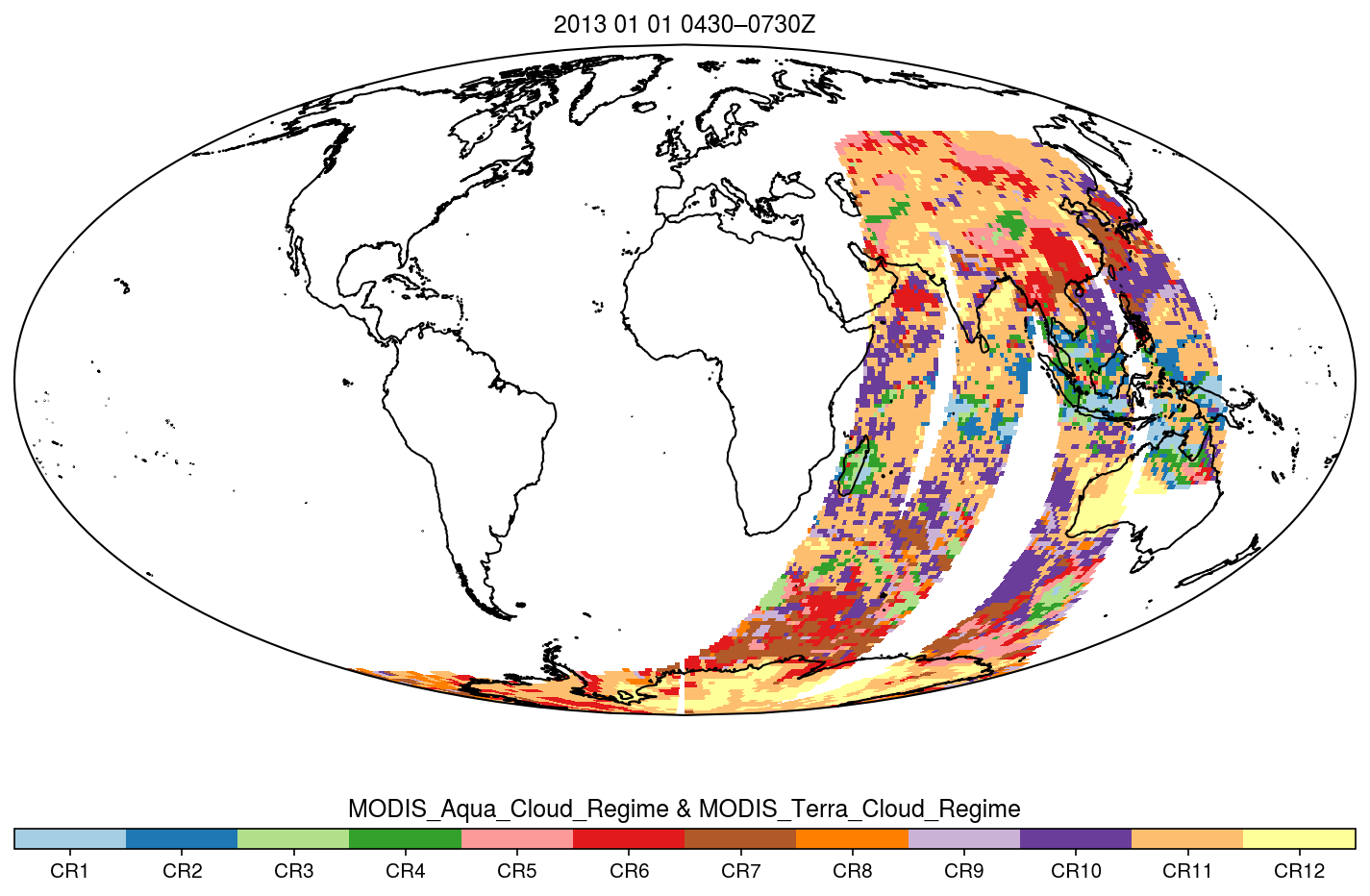
MODIS_CR_Equal_Area_3h
National Aeronautics and Space Administration —
The MODIS Collection 6.1 Equal-Area Three-Hourly Cloud Regime product. This product is a discrete classification of cloud fields at the mesoscale as observed by the... -
Federal
Gamma Ray Data: Peck (FIFE)
National Aeronautics and Space Administration —
Airborne soil moisture measurement is based on the difference between natural terrestrial gamma radiation flux measured for comparatively wet and dry soils. The...

Official websites use .gov
A
.gov website belongs to an official government
organization in the United States.
Secure .gov websites use HTTPS
A
lock (
) or https:// means you’ve safely connected to
the .gov website. Share sensitive information only on official,
secure websites.