
-
Federal
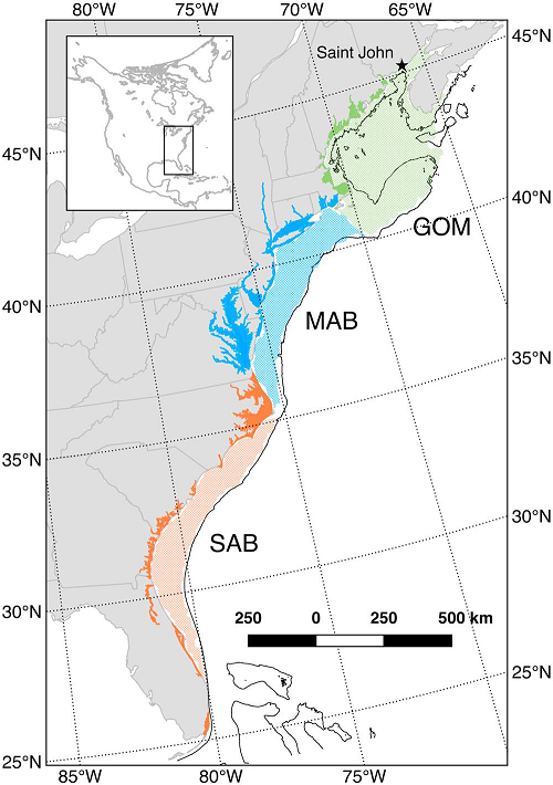
Mid-Atlantic coastal region measurements in 2005
National Aeronautics and Space Administration —
Measurements made near the mid-Atlantic coastal region of the continental shelf in 2005. -
Federal
SCOAPE-II R/V Point Sur Data
National Aeronautics and Space Administration —
SCOAPE2_RVPointSur_Data is the data collected from instruments onboard the University of Southern Mississippi’s Research Vessel (R/V) Point Sur during the Satellite... -
Federal
Mid-Atlantic coastal region measurements
National Aeronautics and Space Administration —
Measurements made near the mid-Atlantic coastal region of the continental shelf in 2005 and 2006. -
Federal
NOAA Fisheries Ecosystem Monitoring Program
National Aeronautics and Space Administration —
EcoMon is the NOAA Northeast Fisheries Science Center Ecosystem Monitoring program for the Northeast U.S. continental shelf. EcoMon main objective is hydrography and... -
Federal
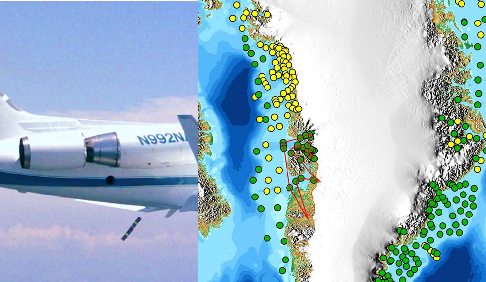
OMG Airborne eXpendable Conductivity Temperature Depth (AXCTD) Profiles
National Aeronautics and Space Administration —
This dataset contains in situ profile measurements from Airborne eXpendable Conductivity Temperature Depth (AXCTD) probes. It provides salinity, density, temperature... -
Federal
Ice Draft and Ice Velocity Data in the Beaufort Sea, 1990-2003, Version 1
National Aeronautics and Space Administration —
This data set provides measurement of sea ice draft (m) and the movement of sea ice (cm/s) over the continental shelf of the Eastern Beaufort Sea. The data set spans... -
Federal
Northeast U.S. Shelf (NES), Long-Term Ecological Research (LTER)
National Aeronautics and Space Administration —
The Northeast U.S. Shelf (NES) Long-Term Ecological Research (LTER) project integrates observations, experiments, and models to understand and predict how planktonic... -
Federal
SCOAPE Balloon and Ozonesondes Data
National Aeronautics and Space Administration —
SCOAPE_Sondes_Data is the NO2-sonde and ozonesonde data collected during the Satellite Coastal and Oceanic Atmospheric Pollution Experiment (SCOAPE). Data were... -
Federal
Impacts of Climate Variability on Primary Productivity and Carbon Distributions in the Middle Atlantic Bight and Gulf of Maine (CliVEC)
National Aeronautics and Space Administration —
Title: The Impacts of Climate Variability on Primary Productivity and Carbon Distributions in the Middle Atlantic Bight and Gulf of Maine (CliVEC)Research Team:... -
Federal
Mean Annual Fluxes of Carbon in Coastal Ecosystems of Eastern North America
National Aeronautics and Space Administration —
This dataset contains best estimates and uncertainties for mean annual fluxes of inorganic, organic, and total (organic + inorganic) carbon in tidal wetlands,... -
Federal
CARIACO Ocean Time Series program, Cariaco Basin, Venezuela
National Aeronautics and Space Administration —
Since November 1995, the CARIACO Ocean Time Series program has been studying the relationship between surface biogeochemical processes and the vertical fluxes of... -
Federal
Bering Ecosystem STudy (BEST) project
National Aeronautics and Space Administration —
The HLY0803 cruise of the USCG cutter Healy was an NSF funded cruise for the Bering Ecosystem Study (BEST) project that was focused on the impact of sea ice on the... -
Federal
SCOAPE R/V Point Sur Data
National Aeronautics and Space Administration —
SCOAPE_RVPointSur_Data is the data collected from instruments onboard the University of Southern Mississippi’s Research Vessel (R/V) Point Sur during the Satellite... -
Federal
SCOAPE-II Sondes Data
National Aeronautics and Space Administration —
SCOAPE2_Sondes_Data is the ozonesonde data collected during the Satellite Coastal and Oceanic Atmospheric Pollution Experiment - II (SCOAPE-II). Data collection for... -
Federal
OMG Level 2 Airborne eXpendable Bathy Thermograph (AXBT) Profiles
National Aeronautics and Space Administration —
This dataset contains Level 2 in situ temperature profile measurements from the Airborne eXpendable BathyThermograph (AXBT) probes. It provides science quality... -
Federal
Gulf of Maine North Atlantic Time Series (GNATS)
National Aeronautics and Space Administration —
The Gulf of Maine (GoM) is a highly productive shelf sea that constitutes a large part of the N.E. US Continental Shelf. We have run a time series across the GoM for... -
Federal
Ocean Margin Exchange Phase II (OMEX II) Project
National Aeronautics and Space Administration —
Measurements made under the OMEX-II project were made along the Northwest European continental shelf between 1997 and 1999. -
Federal
SCOAPE Pandora Column Observations
National Aeronautics and Space Administration —
SCOAPE_Pandora_Data is the column NO2 and ozone data collected by Pandora spectrometers during the Satellite Coastal and Oceanic Atmospheric Pollution Experiment... -
Federal
SCOAPE Ground Site Data
National Aeronautics and Space Administration —
SCOAPE_Ground_Data is the ground site data collected during the Satellite Coastal and Oceanic Atmospheric Pollution Experiment (SCOAPE). The ground site was located...

Official websites use .gov
A
.gov website belongs to an official government
organization in the United States.
Secure .gov websites use HTTPS
A
lock (
) or https:// means you’ve safely connected to
the .gov website. Share sensitive information only on official,
secure websites.