
-
Federal
OMI/Aura Ozone (O3) Total Column 1-Orbit L2 Swath 13x24 km V003 NRT
National Aeronautics and Space Administration —
The OMI/Aura Level-2 Total Column Ozone Data Product OMTO3 Near Real Time data is made available from the OMI SIPS NASA for the public access. The Ozone Monitoring... -
Federal
FIREX-AQ Remotely Sensed Trace Gas Data
National Aeronautics and Space Administration —
FIREXAQ_TraceGas_AircraftRemoteSensing_DC8_Data are remotely sensed trace gas measurements conducted onboard the DC8 aircraft during FIREX-AQ. This product features... -
Federal
SnowEx23 Airborne Lidar Scans Raw V001
National Aeronautics and Space Administration —
This data set provides raw lidar data from two regions of Alaska, USA collected as part of the NASA SnowEx 2023 field campaign. The study sites include a boreal... -
Federal
Pyrocumulonimbus Events over British Columbia in August 2017: Results from the NASA GEOS Earth System Model
National Aeronautics and Space Administration —
Model data associated with the manuscript submitted in Atmospheric Chemistry and Physics Journal, titled, " Pyrocumulonimbus Events over British Columbia in 2017: The... -
Federal
CERES and GEO-Enhanced TOA, Within-Atmosphere and Surface Fluxes, Clouds and Aerosols Monthly-Averaged 1-Hourly Terra-Aqua Edition4A
National Aeronautics and Space Administration —
CER_SYN1deg-MHour_Terra-Aqua-MODIS_Edition4A is the Clouds and the Earth's Radiant Energy System (CERES) and geostationary (GEO)-Enhanced Top-of-Atmosphere (TOA),... -
Federal
CERES and GEO-Enhanced TOA, Within-Atmosphere and Surface Fluxes, Clouds and Aerosols 1-Hourly Terra-Aqua Edition4A
National Aeronautics and Space Administration —
CER_SYN1deg-1Hour_Terra-Aqua-MODIS_Edition4A is the Clouds and the Earth's Radiant Energy System (CERES) and geostationary (GEO) Top-of-Atmosphere (TOA) Within-... -
Federal
CERES and GEO-Enhanced TOA, Within-Atmosphere and Surface Fluxes, Clouds and Aerosols Monthly Terra-NOAA20 Edition4A
National Aeronautics and Space Administration —
CER_SYN1deg-Month_Terra-NOAA20_Edition4A is the Clouds and the Earth's Radiant Energy System (CERES) and geostationary (GEO)-Enhanced Top of Atmosphere (TOA), Within-... -
Federal
MODIS/Terra Cloud Mask and Spectral Test Results 5-Min L2 Swath 250m and 1km
National Aeronautics and Space Administration —
The MODIS/Terra Cloud Mask and Spectral Test Results 5-Min L2 Swath 250m and 1km product consists of global cloud mask quality assurance and other ancillary... -
Federal
DISCOVER-AQ Texas Deployment Analysis and Ancillary Ground Site Data
National Aeronautics and Space Administration —
DISCOVERAQ_Texas_Ground_Analysis_Ancillary_Data contains data collected at ancillary ground sites during the Texas (Houston) deployment of NASA's DISCOVER-AQ field... -
Federal
JPL SMAP Level 2B Near Real-time CAP Sea Surface Salinity V5.0 Validated Dataset (2 hour latency)
National Aeronautics and Space Administration —
The SMAP-SSS V5.0, level 2B (NRT CAP) dataset produced by the Jet Propulsion Laboratory Combined Active-Passive (CAP) project , is a validated product that provides... -
Federal
Jason-3 Wet Path Delay Correction
National Aeronautics and Space Administration —
This dataset provides supplementary wet tropospheric corrections for historical Jason-3 observations (https://www.ncei.noaa.gov/archive/accession/Jason3-xGDR). Recent... -
Federal
ASTER Digital Elevation Model V003
National Aeronautics and Space Administration —
The Terra Advanced Spaceborne Thermal Emission and Reflection Radiometer (ASTER) Digital Elevation Model (AST14DEM) product is generated using bands 3N (nadir-... -
Federal
FIREX-AQ Analysis and Supplementary Data
National Aeronautics and Space Administration —
FIREXAQ_Analysis_Data are supplementary analysis and ancillary data collected during FIREX-AQ. This product includes plume ratios, and supplementary datasets... -
Federal
LBA-ECO TG-07 Ground-based Biometry Data at km 83 Site, Tapajos National Forest: 1997
National Aeronautics and Space Administration —
Changes in the biomass of Amazon region forests represent an important component of the global carbon cycle but the biomass of these forests remains poorly... -
Federal
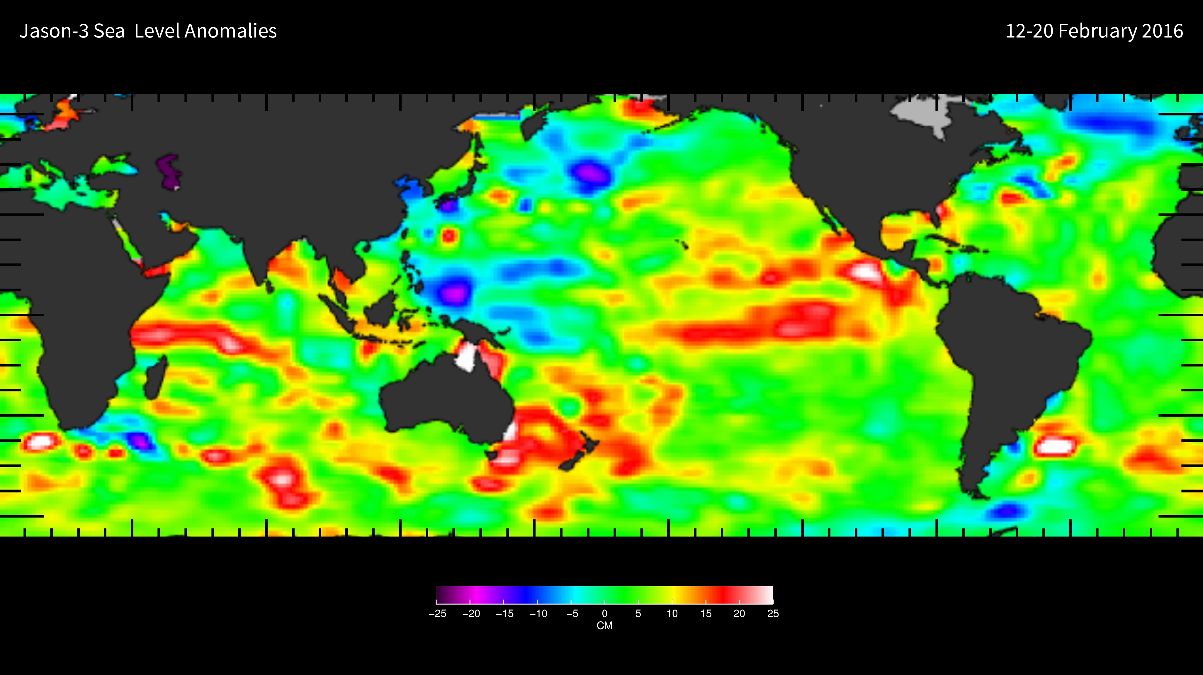
NASA-SSH ENSO Sea Surface Height Indicator
National Aeronautics and Space Administration —
This file contains an indicator for the El Nino-Southern Oscillation (ENSO), based on satellite observations of sea surface height anomaly, measured by radar... -
Federal
TOVS GLA MONTHLY GRIDS from NOAA-11 V01 (TOVSAMNH) at GES DISC
National Aeronautics and Space Administration —
This dataset (TOVSAMNH) contains the TIROS Operational Vertical Sounder (TOVS) level 3 geophysical parameters derived using data from NOAA-11 and the physical... -
Federal
CERES Single Scanner Footprint (SSF) TOA/Surface Fluxes, Clouds and Aerosols Terra-FM1 Edition4A
National Aeronautics and Space Administration —
CER_SSF_Terra-FM1-MODIS_Edition4A is the Clouds and the Earth's Radiant Energy System (CERES) Single Scanner Footprint (SSF) Top-of-the-Atmosphere (TOA)/Surface... -
Federal
MEaSUREs Greenland Ice Mapping Project (GrIMP) Digital Elevation Model from GeoEye and WorldView Imagery V002
National Aeronautics and Space Administration —
This data set consists of an enhanced resolution digital elevation model (DEM) for the Greenland Ice Sheet, derived from sub-meter resolution, panchromatic...

Official websites use .gov
A
.gov website belongs to an official government
organization in the United States.
Secure .gov websites use HTTPS
A
lock (
) or https:// means you’ve safely connected to
the .gov website. Share sensitive information only on official,
secure websites.