
-
Federal
NCEP North American Regional Reanalysis (NARR), for 1979 to Present recent views
National Oceanic and Atmospheric Administration, Department of Commerce —
The North America Regional Reanalysis (NARR) Project is a reanalysis of historical observations using a 32-km version of the National Centers for Environmental... -
Federal
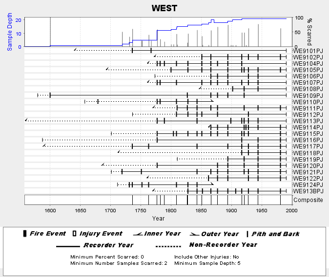
NOAA/WDS Paleoclimatology - Skinner fire data from WEST (San Pedro Martir) - IMPD MXWES001 recent views
National Oceanic and Atmospheric Administration, Department of Commerce —
This archived Paleoclimatology Study is available from the NOAA National Centers for Environmental Information (NCEI), under the World Data Service (WDS) for... -
Federal
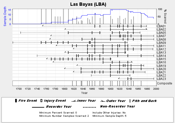
NOAA/WDS Paleoclimatology - Heyerdahl fire data from Las Bayas (LBA) - IMPD MXLBA001 recent views
National Oceanic and Atmospheric Administration, Department of Commerce —
This archived Paleoclimatology Study is available from the NOAA National Centers for Environmental Information (NCEI), under the World Data Service (WDS) for... -
Federal
Historical Map & Chart Collection of NOAA's Nautical Charts, Hydrographic Surveys, Topographic Surveys, Geodetic Surveys, City Plans, and Civil War Battle Maps Starting from the mid 1700's recent views
National Oceanic and Atmospheric Administration, Department of Commerce —
The Historical Map and Chart Collection of the Office of Coast Survey contains over 20000 historical maps and charts from the mid 1700s through the late 1900s. These... -
Federal
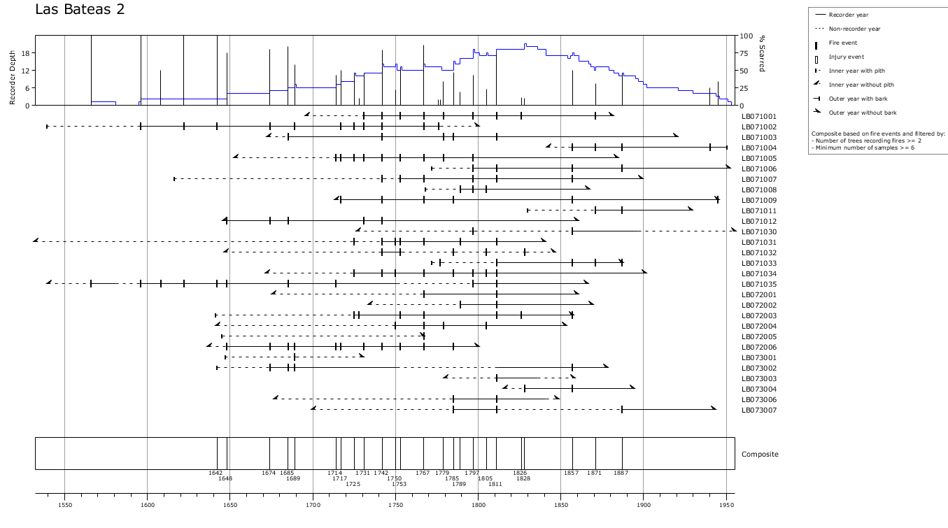
NOAA/WDS Paleoclimatology - Yocom fire data from Las Bateas 2, Sierra Madre Oriental, Coahuila, Mexico - IMPD MXLB-001 recent views
National Oceanic and Atmospheric Administration, Department of Commerce —
This archived Paleoclimatology Study is available from the NOAA National Centers for Environmental Information (NCEI), under the World Data Service (WDS) for... -
Federal
NOAA/WDS Paleoclimatology - Yocom fire data from Orizaba 4, eastern Transvolcanic Belt, Puebla, Mexico - IMPD MXOZ4001 recent views
National Oceanic and Atmospheric Administration, Department of Commerce —
This archived Paleoclimatology Study is available from the NOAA National Centers for Environmental Information (NCEI), under the World Data Service (WDS) for... -
Federal
NOAA/WDS Paleoclimatology - Yocom fire data from San Onofre, Sierra Madre Oriental, Nuevo León, Mexico - IMPD MXSO-001 recent views
National Oceanic and Atmospheric Administration, Department of Commerce —
This archived Paleoclimatology Study is available from the NOAA National Centers for Environmental Information (NCEI), under the World Data Service (WDS) for... -
Federal
The Olympia & Pacific Oyster Data Portal recent views
National Oceanic and Atmospheric Administration, Department of Commerce —
Locations (i.e., "records") of Ostrea lurida (Olympia oysters) and Magallana gigas (Pacific oysters) observed 1602 to 2020 along the west coast of North America.... -
Federal
NOAA/WDS Paleoclimatology - Yocom fire data from Orizaba 6, eastern Transvolcanic Belt, Puebla, Mexico - IMPD MXOZ6001 recent views
National Oceanic and Atmospheric Administration, Department of Commerce —
This archived Paleoclimatology Study is available from the NOAA National Centers for Environmental Information (NCEI), under the World Data Service (WDS) for... -
Federal
NOAA/WDS Paleoclimatology - Yocom fire data from Orizaba 1, eastern Transvolcanic Belt, Puebla, Mexico - IMPD MXOZ1001 recent views
National Oceanic and Atmospheric Administration, Department of Commerce —
This archived Paleoclimatology Study is available from the NOAA National Centers for Environmental Information (NCEI), under the World Data Service (WDS) for... -
Federal
NOAA/WDS Paleoclimatology - Heyerdahl fire data from El Carpintero (CAR) - IMPD MXCAR001 recent views
National Oceanic and Atmospheric Administration, Department of Commerce —
This archived Paleoclimatology Study is available from the NOAA National Centers for Environmental Information (NCEI), under the World Data Service (WDS) for... -
Federal
NOAA/WDS Paleoclimatology - Yocom fire data from Orizaba 3, eastern Transvolcanic Belt, Puebla, Mexico - IMPD MXOZ3001 recent views
National Oceanic and Atmospheric Administration, Department of Commerce —
This archived Paleoclimatology Study is available from the NOAA National Centers for Environmental Information (NCEI), under the World Data Service (WDS) for... -
Federal
NOAA/WDS Paleoclimatology - Yocom fire data from ParaÃso, Sierra Madre Oriental, Coahuila, Mexico - IMPD MXPA-001 recent views
National Oceanic and Atmospheric Administration, Department of Commerce —
This archived Paleoclimatology Study is available from the NOAA National Centers for Environmental Information (NCEI), under the World Data Service (WDS) for... -
Federal
Hurricane Katrina Poster (August 28, 2005) recent views
National Oceanic and Atmospheric Administration, Department of Commerce —
Hurricane Katrina poster. Multi-spectral image from NOAA-18 shows a very large Hurricane Katrina as a category 5 hurricane in the Gulf of Mexico on August 28, 2005.... -
Federal
Annual survival of Yucatan nesting loggerheads recent views
National Oceanic and Atmospheric Administration, Department of Commerce —
We deployed 30 Pop-off Archival Transmitting (PAT) satellite tags on nesting loggerhead turtles between 7 July and 11 July 2010 at Xel-Ha, XCacel, and Playa Aventuras... -
Federal
Near-real-time surface ocean velocities derived from HF radar stations located along coastal waters of North Slope Alaska, Puerto Rico/Virgin Islands, eastern US/Gulf of Mexico, Hawaii and western US recent views
National Oceanic and Atmospheric Administration, Department of Commerce —
This archival package contains near-real-time ocean surface velocities, also known as total vector velocities, derived from HF radar stations. The velocities are... -
Federal
NOAA/WDS Paleoclimatology - Skinner fire data from BLAN (San Pedro Martir) - IMPD MXBLA001 recent views
National Oceanic and Atmospheric Administration, Department of Commerce —
This archived Paleoclimatology Study is available from the NOAA National Centers for Environmental Information (NCEI), under the World Data Service (WDS) for... -
Federal
NOS Hydrodynamic Model Outputs of Operational Forecast System (OFS) recent views
National Oceanic and Atmospheric Administration, Department of Commerce —
NOAA develops, operates and maintains a national network of operational nowcast and forecast hydrodynamic modeling systems referred to as Operational Forecast Systems... -
Federal
Airborne Gravity: NGS' Gravity Data for CS07 (2014 & 2016) recent views
National Oceanic and Atmospheric Administration, Department of Commerce —
Airborne gravity data for Texas collected in 2014 & 2016 over 3 surveys,TX14-2, TX16-1 and TX16-2. This data set is part of the Gravity for the Re-definition of...

Official websites use .gov
A
.gov website belongs to an official government
organization in the United States.
Secure .gov websites use HTTPS
A
lock (
) or https:// means you’ve safely connected to
the .gov website. Share sensitive information only on official,
secure websites.