
-
Federal
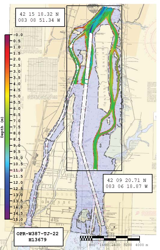
H13679: NOS Hydrographic Survey , 2022-08-22
National Oceanic and Atmospheric Administration, Department of Commerce —
The National Oceanic and Atmospheric Administration (NOAA) has the statutory mandate to collect hydrographic data in support of nautical chart compilation for safe... -
Federal
H13619: NOS Hydrographic Survey , 2022-08-23
National Oceanic and Atmospheric Administration, Department of Commerce —
The National Oceanic and Atmospheric Administration (NOAA) has the statutory mandate to collect hydrographic data in support of nautical chart compilation for safe... -
Federal
GL_StClair_Detroit_River 2019 ESI NAVIGATION/MARINE Polygons, Lines, Points
National Oceanic and Atmospheric Administration, Department of Commerce —
These feature classes reside within the SOCECON Feature Data Set of the Great Lakes - St. Clair / Detroit River System 2019 ESI geodatabase. They contain vector... -
Federal
GL_StClair_Detroit_River 2019 ESI HABITATS Polygons
National Oceanic and Atmospheric Administration, Department of Commerce —
This feature class resides within the BIOLOGY Feature Data Set of the Great Lakes - St. Clair / Detroit River System - 2019 ESI Geodatabase. It contains vector... -
Federal
GL_StClair_Detroit_River 2019 ESI BIRD Polygons, Points
National Oceanic and Atmospheric Administration, Department of Commerce —
This feature class resides within the BIOLOGY Feature Data Set of the Great Lakes - St. Clair / Detroit River System - 2019 ESI Geodatabase. It contains vector... -
Federal
GL_StClair_Detroit_River 2019 ESI HERP Polygons
National Oceanic and Atmospheric Administration, Department of Commerce —
This feature class resides within the BIOLOGY Feature Data Set of the Great Lakes - St. Clair / Detroit River System - 2019 ESI Geodatabase. It contains vector... -
Federal
GL_StClair_Detroit_River 2019 ESI T_MAMMAL Polygons
National Oceanic and Atmospheric Administration, Department of Commerce —
This feature class resides within the BIOLOGY Feature Data Set of the Great Lakes - St. Clair / Detroit River System - 2019 ESI Geodatabase. It contains vector... -
Federal
GL_StClair_Detroit_River 2019 ESI BENTHIC Polygons
National Oceanic and Atmospheric Administration, Department of Commerce —
This feature class resides within the BIOLOGY Feature Data Set of the Great Lakes - St. Clair / Detroit River System - 2019 ESI Geodatabase. It contains vector... -
Federal
GL_StClair_Detroit_River 2019 ESI INVERT Polygons, Lines
National Oceanic and Atmospheric Administration, Department of Commerce —
This feature class resides within the BIOLOGY Feature Data Set of the Great Lakes - St. Clair / Detroit River System - 2019 ESI Geodatabase.. It contains vector... -
Federal
GL_StClair_Detroit_River 2019 ESI POLITICAL/JURISDICTIONAL Polygons
National Oceanic and Atmospheric Administration, Department of Commerce —
This feature class resides within the SOCECON Feature Data Set of the Great Lakes - St. Clair / Detroit River System 2019 ESI geodatabase. It contains vector polygons... -
Federal
GL_StClair_Detroit_River 2019 ESI HYDRO Polygons, Lines
National Oceanic and Atmospheric Administration, Department of Commerce —
The feature classes HYDROL and HYDROP contain vector lines and polygons representing the coastal shoreline and hydrography used in the creation of the Environmental... -
Federal
GL_StClair_Detroit_River 2019 ESI NATURAL HAZARD Polygons
National Oceanic and Atmospheric Administration, Department of Commerce —
This feature class resides within the SOCECON Feature Data Set of the Great Lakes - St. Clair / Detroit River System 2019 ESI geodatabase. It contains vector polygons... -
Federal
GL_StClair_Detroit_River 2019 ESI RESOURCE MANAGEMENT Polygons, Points
National Oceanic and Atmospheric Administration, Department of Commerce —
These feature classes reside within the SOCECON Feature Data Set of the Great Lakes - St. Clair / Detroit River System 2019 ESI geodatabase. They contain vector... -
Federal
GL_StClair_Detroit_River 2019 ESI SOCECON Polygons, Lines, Points
National Oceanic and Atmospheric Administration, Department of Commerce —
These feature classes reside within the SOCECON Feature Data Set of the Great Lakes - St. Clair / Detroit River System 2019 ESI geodatabase. They contain vector... -
Federal
GL_StClair_Detroit_River 2019 ESI FISH Polygons, Lines, Points
National Oceanic and Atmospheric Administration, Department of Commerce —
This feature class resides within the BIOLOGY Feature Data Set of the Great Lakes - St. Clair / Detroit River System - 2019 ESI Geodatabase. It contains vector... -
Federal
GL_StClair_Detroit_River 2019 ESI PARKS/MANAGED Polygons, Lines, Points
National Oceanic and Atmospheric Administration, Department of Commerce —
These feature classes reside within the SOCECON Feature Data Set of the Great Lakes - St. Clair / Detroit River System 2019 ESI geodatabase. They contain vector... -
Federal
GL_StClair_Detroit_River 2019 ESI Polygons, Lines
National Oceanic and Atmospheric Administration, Department of Commerce —
The feature classes ESIL and ESIP contain vector lines and polygons representing shorelines and intertidal habitats of Great Lakes - St. Clair / Detroit River System... -
Federal
Shoreline Mapping Program of DETROIT RIVER, LAKE ST CLAIR TO LAKE ERIE, MI-ONT, OH0906A NGDA
National Oceanic and Atmospheric Administration, Department of Commerce —
These data provide an accurate high-resolution shoreline compiled from imagery of DETROIT RIVER, LAKE ST CLAIR TO LAKE ERIE, MI-ONT . This vector shoreline data is... -
Federal
Shoreline Data Rescue Project of Detroit River, PH7118 NGDA
National Oceanic and Atmospheric Administration, Department of Commerce —
These data were automated to provide an accurate high-resolution historical shoreline of Detroit River suitable as a geographic information system (GIS) data layer....

Official websites use .gov
A
.gov website belongs to an official government
organization in the United States.
Secure .gov websites use HTTPS
A
lock (
) or https:// means you’ve safely connected to
the .gov website. Share sensitive information only on official,
secure websites.